Gopher Tortoises, Making Deep and Meaningful Burrows

As I wrote this post, I was flying from Atlanta, Georgia to Minneapolis, Minnesota to attend the annual meeting of the Geological Society of America (GSA), where I’ll be with about 7-8,000 geoscientists from across and outside of the U.S. Why am I not doing something else, such as field work on the Georgia coast? Well, other than to learn the latest of what’s happening in the world of geology, seeing old friends, and meeting new ones, I’m here to share new scientific knowledge coming out of the Georgia coast with my fellow geologists and paleontologists. The subject of the presentation I will give tomorrow – Tuesday, October 11 – is about the wondrous burrows of a humble-looking, slow-moving, and seemingly lethargic reptile that actually is an ichnological force of nature: the gopher tortoise (Gopherus polyphemus).
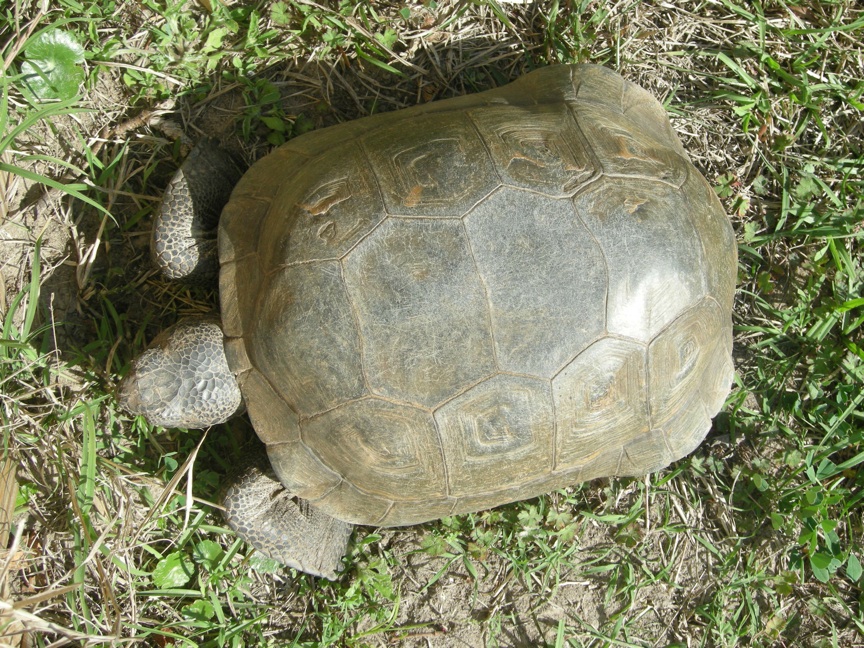
A gopher tortoise in captivity, but living a safe and happy life at the 4-H Tidelands Nature Center on Jekyll Island, Georgia. Although it may not look like a big deal, it is a very impressive tracemaker, deserving the rapt attention of geologists and paleontologists. (Photograph taken by Anthony Martin.)

So you’re probably wondering why geologists and paleontologists should hear about gopher tortoises from me. It’s a good question, because I’m not a biologist, and these animals are famous for their very important role in ecosystems. Specifically, they are well known as keystone species in the sandy soils of longleaf pine-wiregrass communities of the southeastern U.S. Just like the keystone to a building, once you remove gopher tortoises from their ecosystems, a lot of other species disappear with it. Surprisingly, their ecological worth all revolves around their burrows.

And oh, what marvelous and grandiose burrows they make! The lengthiest of their measured burrows approach 14 meters (45 feet) long and as much as 6 meters (20 feet) vertically below the ground surface. These burrows commonly twist to the right or left on their way down, which probably helps protect its tortoise occupant against predators, while maintaining a constant temperature and humidity in the burrow. With so much digging, of course, a lot of sand has to be excavated, so the locations of their burrows are easily spotted by looking for piles of sand in the middle of a grassy field or in a longleaf-pine forest. For female tortoises, these sand piles also serve as nesting sites, where they bury their eggs to incubate.
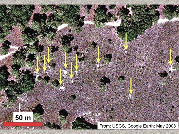
Satellite view of gopher-tortoise burrows on St. Catherines Island, Georgia. Nearly all of the white spots you see in the photo – indicated by the yellow arrows – are the sand piles (aprons) outside of their burrows. Look closely, and you can see some of the trails worn down by tortoises traveling between burrows. Yes, these are animal traces you can see from space! (Original image from the U.S. Geological Survey and Google Earth, taken in May 2008.)
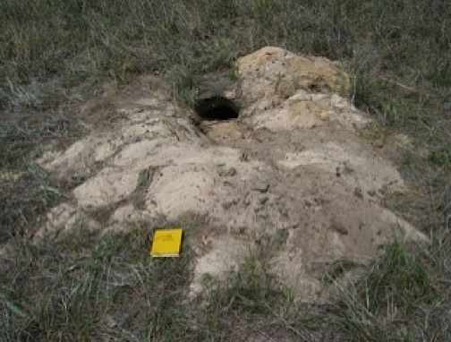
Close-up view of a sand apron outside of a gopher-tortoise burrow entrance. The large amount of sand tells you that this must be a very deep burrow. Field notebook is about 15 cm (6 in) long. (Photograph taken by Anthony Martin on St. Catherines Island, Georgia.)

In cross-section, their burrows have flat bottoms and rounded tops, similar to a tortoise body. Burrow widths varies with the length of the tortoise, as it needs to be wide enough for the tortoise to turn around in the burrow. So this means a 30-cm (12 in) wide burrow can accommodate a tortoise of that length or less. The powerful front limbs of tortoises are specially adapted for digging, ending in flat, spade-like feet with stout claws. Burrow walls are compacted by the hard shell of the tortoise as it moves up and down the burrow. These burrows descend steeply, at angles of 20-40°, which means they have to be good climbers to get out of their deep burrows.
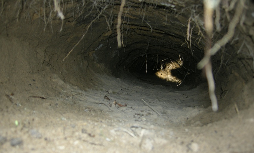
Down-tunnel view of a gopher-tortoise burrow, with the light at the end of that tunnel not  from an oncoming train, but reflected morning sunlight on the tunnel wall at one of its turns. (Photograph by Anthony Martin, taken on St. Catherines Island, Georgia.)

Now think about a tunnel that’s about 10 m (33 ft) long and 30 cm (12 in) wide, and how much space that represents underneath the ground, and you’ll see what I mean about the vital role of these burrows ecologically, geologically, and (most importantly) ichnologically. In terms of ecology, about 200-300 species of invertebrate and vertebrate animals cohabit these burrows (whether a gopher tortoise is in it or not), including the longest snake in North America, the eastern indigo snake (Drymarchon couperi), the secretive gopher frog (Rana capito), the Florida mouse (Podomys floridanus), and a bunch of different insects. At least a few of the insects and the Florida mice make their own burrows, thus adding their little homes to the main burrow, like small anterooms to a big mansion.
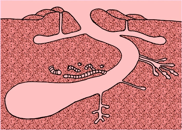
Idealized conceptual sketch showing a cut-away view through a gopher-tortoise burrow with many additional burrows made by other animal species. Note especially the short horizontal tunnels near the burrow top, which would have been made by hatchling tortoises, and the vertical shafts that connect to these, which would have been made by Florida mice. (Illustration by Anthony Martin.)

So now you can see why this ichnologist (that would be me) became rather enamored with these burrows. For one thing, they have great preservation potential in the fossil record. A  general rule in ichnology for the preservation of burrows is “deeper is better,” in that burrows that go to great depths are less likely to be eroded by surface weathering and erosion, and more likely to be fossilized. Secondly, we know that vertebrate animals in the geologic past also made big burrows, such as synapsids and even small dinosaurs. I’ve done research on the few dinosaur burrows interpreted from the geologic record, and am especially interested in how such large burrows might compare with similar burrows made by modern animals, such as gopher tortoises.

But how to study these burrows without digging them out and leaving the tortoises undisturbed? Fortunately, two colleagues of mine at Georgia Southern University – Sheldon Skaggs and Robert (Kelly) Vance – came up with an elegant solution, which was to use ground-penetrating radar, also known by its acronym of GPR. This method uses a portable unit to transmit microwaves underground (don’t worry, not these aren’t intense enough to cook the tortoises), which reflect off surfaces with different qualities, especially the curved, compacted surfaces of burrow walls. Computers then process and render these reflections into three-dimensional images that more-or-less represent the forms and geometries of the burrows.

Sure enough, we tried out this technique on gopher-tortoise burrows on St. Catherines Island of the Georgia coast in January and July this year. Although we can’t share all of our results just yet, we did successfully make three-dimensional images of the burrows, all without us having to burrow ourselves, or bother the tortoises by becoming homewreckers. Veronica Greco, a wildlife biologist on St. Catherines Island who has studied the behavior and breeding of the tortoises, also helped us to better understand the biology of these reptiles.
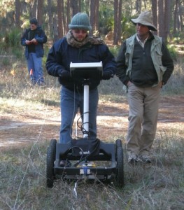
Although it looks like Sheldon (center) is mowing the lawn and I’m (right) just supervising, he’s actually pushing a portable ground-penetrating radar (GPR) unit over a field that has some gopher-tortoise burrows in it, while I walk alongside to look at the reflection profiles. Kelly (background) is no doubt monitoring our every move, but is also recording our location. (Photograph by Ruth Schowalter, taken on St. Catherines Island, Georgia.)

My talk at the GSA meeting will be about how we used GPR to study the burrows in a non-invasive way, and how our results might be applied to studying similar burrows in the fossil record. After the meeting is over, we plan to summarize our results in a research article, which we’ll submit to a journal later this year for peer review.

Unfortunately, gopher tortoises are endangered because of huge losses in acreage of longleaf-pine forests in the southeastern U.S. during the past 200 years or so. Knowing this makes our study of their burrows even more meaningful, for if these wonderful tracemakers go extinct in the near future, we will not have the chance to study them and their burrows. In this sense then, only geologists and paleontologists who know about their ichnology through studies like ours will be able to study their burrows, which would be a sad thing indeed. Let’s hope they survive and thrive, and we can continue to learn more about these superb burrowing animals and their traces.

(P.S. Many thanks to the St. Catherines Island Foundation for their support of our research!)

Further Reading

Aresco, M.J., 1999. Habitat structures associated with juvenile gopher tortoise burrows on pine plantations in Alabama. Chelonian Conservation and Biology, 3: 507-509.

Doonan, T.J., and Stout, I.J., 1994. Effects of gopher tortoise (Gopherus polyphemus) body size on burrow structure. American Midland Naturalist, 131: 273-280.

Epperson, D.M., and Heise, C.D., 2003. Nesting and hatchling ecology of gopher tortoises (Gopherus polyphemus) in southern Mississippi. Journal of Herpetology, 37: 315-324.

Guyer, C., and Hermann, S.M. 1997. Patterns of size and longevity for gopher tortoise burrows: implications for the longleaf pine-wiregrass ecosystem. Bulletin of the Ecological Society of America, 78: 254.

Jackson, D.R. and Milstrey, E.R. 1989. The fauna of gopher tortoise burrows. In Diemer, J.E. (editor), Proceedings of the Gopher Tortoise Relocation Symposium, State of Florida, Game and Freshwater Fish Commission, Tallahassee, Florida: 86-98.

Jones, C.A., and Franz, R. 1990. Use of gopher tortoise burrows by Florida mice (Podomys floridanus) in Putnam County, Florida. Florida Field Naturalist, 18: 45-68.

Lips, K.R. 1991. Vertebrates associated with tortoise (Gopherus polyphemus) burrows in four habitats in south central Florida. Journal of Herpetology, 25: 477-481.

Martin, A.J., Skaggs, S.A., Vance, R.K., and Greco, V. 2011. Ground-penetrating radar investigation of gopher-tortoise burrows: refining the characterization of modern vertebrate burrows and associated commensal traces. Geological Society of America Abstracts with Programs, 43(5): 381.

Varricchio, D.J., Martin, A.J., and Katsura, Y. 2007. First trace and body fossil evidence of a burrowing, denning dinosaur. Proceedings of the Royal Society of London, B, 274: 1361-1368.

Witz, B.W., and Wilson, D.S., and Palmer, M.D. 1991. Distribution of Gopherus polyphemus and its vertebrate symbionts in three burrow categories. American Midland Naturalist, 126: 152-158.

The Lost Barrier Islands of Georgia

The Georgia coast is well known for its historic role in the development of modern ecology, starting in the 1950s and ongoing today. But what about geologists? Fortunately, they were not long behind the ecologists, starting their research projects on Sapelo Island and other Georgia barrier islands in the early 1960s. Indeed, through that seminal work and investigations afterwards, these islands are now renown for the insights they bestowed on our understanding of sedimentary geology.

Why would geologists be attracted to these islands made of shifting sand and mud that were nearly devoid of anything resembling a rock? Well, before sedimentary rocks can be made, sediments are needed, and those sediments must get deposited before solidifying into rock. So these geologists were interested in learning how the modern sands and muds of the barrier islands were deposited, eroded, or otherwise moved in coastal environments, a dynamism that can be watched and studied every day along any Georgia shoreline. The products of this sediment movement were sedimentary structures, which were either from physical processes – such as wind, waves, or tides – or biological processes, such as burrowing. Hence sedimentary structures can be classified as either physical or biogenic, respectively.

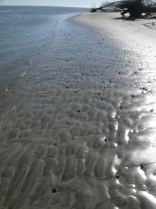
Cabretta Beach on Sapelo Island at low tide, its sandflat adorned with beautiful ripples and many traces of animal life. Sand is abundant here because of a nearby tidal channel and strong ebb-tide currents that tend to deposit more sand than in other places around the island. This sand, in turn, provides lots of places for animals that live on or in the sand, making trails and burrows, demonstrating how ecology and geology intersect through ichnology, the study of traces.  Speaking of traces, what are all of those dark “pipes” sticking out of that sandy surface? Hmmm… (Photograph by Anthony Martin.)

These geologists in the 1960s were among the first people in North America to apply what they observed in modern environments to ancient sedimentary deposits, and just like the ecologists, they did this right here in Georgia. For example, in 1964, a few of these geologists – John H. Hoyt, Robert J. Weimer, and V.J. (“Jim”) Henry – used a combination of: geology, which involved looking at physical sedimentary structures and the sediments themselves; modern traces made by coastal Georgia animals; and trace fossils. Through this integrated approach, they successfully showed that the long, linear sand ridges in southeastern Georgia were actually former dunes and beaches of ancient barrier islands.

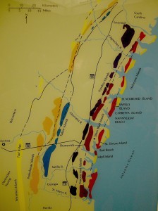
These sand ridges, barely discernible rises on a mostly flat coastal plain, are southwest-northeast trending and more-or-less parallel to the present-day shoreline. Remarkably, these ridges denote the positions of sea-level highs during the last few million years on the Georgia coastal plain. The geologists applied colorful Native American and colonial names to each of these island systems – Wicomico, Penholoway, Talbot, Pamlico, Princess Anne, and Silver Bluff – with the most inland system reflecting the highest sea level. So how did these geologists figure out that a bunch of sand hills were actually lost barrier islands? And what does this all of this have to do with traces and trace fossils?

Map showing positions of sand ridges that represent ancient barrier islands, with each ridge marking the fomer position of the seashore. The one farthest west (Wicomico) represents the highest sea level reached in the past few million years, whereas the current barrier islands reflect an overlapping of two positions of sea level, one from about 40,000 years ago (Silver Bluff), and the other happening now. (Photograph by Anthony Martin, taken of a display at the Sapelo Island Visitor Center.)

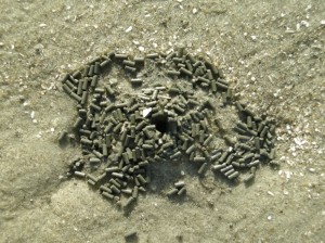
Here’s how they did it. They first observed modern traces on Georgia shorelines that were burrows made by ghost shrimp, also known by biologists as callianassid shrimp. On a sandy beach surface, the tops of these burrows look like small shield volcanoes, and a burrow occupied by a ghost shrimp will complete that allusion by “erupting” water and fecal pellets through a narrow aperture.

Top of a typical callianassid shrimp burrow, looking much like a little volcano and adorned by fecal pellets, which coincidentally resemble “chocolate sprinkles,” but will likely disappoint if you do a taste test. (Photograph by Anthony Martin, taken on St. Catherines Island.)

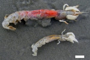
A couple of ghost shrimp, which are either a male-female pair of Carolina ghost shrimp (Callichirus major) or a Carolina ghost shrimp and a Georgia ghost shrimp (Biffarius biformis). Sorry I can’t be more accurate, but I’m an ichnologist, not a biologist (although I could easily play either role on TV). Regardless, notice they have big claws, which they use as their main “digging tools.” The tracemakers look a little displeased about being outside of their protective burrow environments, but be assured I thanked them for their contribution to science, and promptly threw them back in the water so they could burrow again. Scale = 1 cm (0.4 in) (Photograph by Anthony Martin, taken on St. Catherines Island, Georgia.)

Just below the beach surface, these interior shafts widen considerably, making these burrows look more like wine bottles than volcanoes. This widening accommodates the ghost shrimp, which moves up and down the shaft to irrigate its burrow by pumping out its unwanted feces (understandable, that) and circulating oxygenated water into the burrow. Balls of muddy sand reinforce the burrow walls like bricks in a house, stuck together by shrimp spit, and the burrow interior is lined with a smooth wall of packed mud.

A small portion of a ghost-shrimp burrow, showing its wall reinforced by rounded pellets of sand and stuck together with that field-tested and all-natural adhesive, shrimp  spit. Photograph by Anthony Martin, taken on Sapelo Island.

Amazingly, these shafts descend vertically far below the beach, as much as 2-3 meters (6.5-10 feet) deep. Here they turn horizontal, oblique, and vertical, and tunnels intersect, branch, and otherwise look like a complex tangle of piping, perhaps reminding baby-boomers of “jungle gyms” that they used to enjoy as children in a pre-litigation world. Who knows what goes on down there in such adjoining ghost-shrimp burrow complexes, away from prying human eyes?

The deeper part of a modern ghost-shrimp burrow, exposed by erosion along a shoreline and revealing the more complex horizontally oriented and branching networks. Gee, do you think these burrows might have good fossilization potential? (Photograph by Anthony Martin, taken on Sapelo Island.)

See all of those burrow entrances on this sandy beach? Now imagine them all connecting in complex networks below your feet the next time you’re walking along a beach. Feels a little different knowing that, doesn’t it? (Photograph by Anthony Martin, taken on Sapelo Island.)

Interestingly, these burrows are definitely restricted to the shallow intertidal and subtidal environments of the Georgia coast, and their openings are visible at low tide on nearly every Georgia beach. Hence if you found similar burrows in the geologic record, you could reasonably infer where you were with respect to the ancient shoreline.

I think you now know where this is going, and how the geologists figured out what geologic processes were responsible for the sand ridges on the Georgia coastal plain. Before doing field work in those area, the geologists may have already suspected that these sandhills were associated with former shorelines. So with such a hypothesis in mind, they must have been thrilled to find fossil burrows preserved in the ancient sand deposits that matched modern ghost-shrimp burrows they had seen on the Georgia coast. They also found these fossil burrows in Pleistocene-age deposits on Sapelo Island, which helped them to know where the shoreline was located about 40,000 years ago with respect to the present-day one. This is when geologists started realizing that the Georgia barrier islands were made of both Pleistocene and modern sediments as amalgams of two shorelines, and hence unlike any other known barrier islands in the world.

Vertical shaft of a modern ghost-shrimp burrow eroding out of a shoreline on Cabretta Beach, Sapelo Island. Scale in centimeters. (Photograph by Anthony Martin.)

Vertical shaft of a fossil ghost-shrimp burrow eroding out of an outcrop in what is now maritime forest on Sapelo Island, but we know used to be a shoreline because of the presence of this trace fossil. Scale in centimeters. (Photograph by Anthony Martin.)

Geology and ecology combined further later in the 1960s, when paleontologists who also were well trained in biology began looking at how organisms, such as ghost shrimp, ghost crabs, marine worms, and many other animals changed coastal sediments through their behavior. So were these scientists considered geologists, biologists, or ecologists? They were actually greater than the sum of their parts: they were ichnologists. And what they found through their studies of modern traces on the Georgia barrier islands made them even more scientifically famous, and these places became recognized worldwide as among the best for comparing modern traces with trace fossils.

Further Reading:

Hoyt, J.H., and Hails, J.R. 1967. Pleistocene shoreline sediments in coastal Georgia: deposition and modification. Science, 155: 1541-1543.

Hoyt, J.H., Weimer, R.J., and Henry, V.J., Jr. 1964. Late Pleistocene and recent sedimentation on the central Georgia coast, U.S.A. In van Straaten, L.M.J.U. (editor), Deltaic and Shallow Marine Deposits, Developments in Sedimentology I. Elsevier, Amsterdam: 170-176.

Weimer, R.J., and Hoyt, J.H. 1964. Burrows of Callianassa major Say, geologic indicators of littoral and shallow neritic environments. Journal of Paleontology, 38: 761-767.

Georgia Salt Marshes: Places Filled with Traces

The Georgia coast has long captured the attention of scientists interested in its biological and geological systems and how these two realms overlap. For example, starting in the 1950s, ecologists – people who study the connections between living and non-living things in ecosystems – began investigating the exchange of energy and matter between the plants and animals of the Georgia barrier islands. In particular, they were interested in the Georgia salt marshes, most of which are between the mainland and the upland portions of the barrier islands. Why study salt marshes in Georgia, and not somewhere else? And how do the traces of plants and animals in these marshes, such as root disturbances, scrapings, burrows, and feces, actually play a major role in the functioning of these ecosystems?

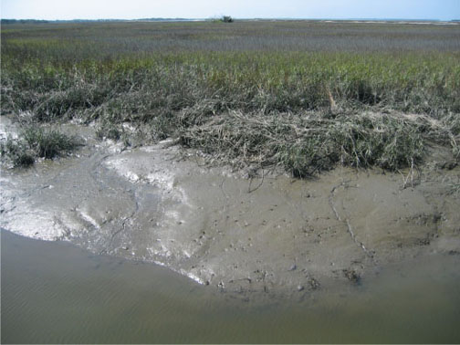
The muddy bank of a tidal creek in a typical salt marsh on St. Catherines Island, Georgia. See the traces? No? It’s a trick question: it’s made of nothing but traces. Photograph by Anthony Martin.

Georgia salt marshes are flat, extensive coastal “prairies” dominated by a tall, marine-adapted grass, smooth cordgrass (Spartina alterniflora) in their lowermost parts. These ecosystems turned out to be fantastic places for scientists to study basic principles of ecology, and are among the most productive of all ecosystems, besting or equaling tropical rain forests in this respect. Georgia salt marshes also represent about one-third of all salt marshes in the eastern U.S. by area. How did this happen?

Such an unusual concentration of salt marshes along the relatively small Georgia coastline is a result of several factors. One is its semi-tropical climate, only rarely dipping below freezing, which allows marsh plants and animals to thrive and actively participate in their ecosystems nearly year-round. Another is the high tidal range of the Georgia coast of about 2.5-3 meters (8-10 feet), which causes enormous amounts of organic material – living and nonliving – to get cycled in and out of the marshes by this moving water.

A third reason, and perhaps the most important, is what people did not do to the marshes, which was to develop them in ways that would have completely altered their original ecological characters. (Take a look at the barrier islands of New Jersey as examples of what could have happened in Georgia.) Salt marshes that were not drained, filled in, paved over, or otherwise irreparably altered could be studied for what they were, not what we supposed.

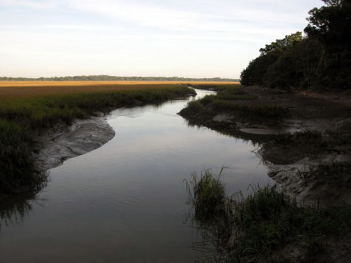
Salt marsh and tidal creek adjacent to a maritime forest on Cumberland Island. Fortunately, this is a typical sight on the Georgia barrier islands, which gladdens ecologists and lots of other people who prefer to see their landscapes unpaved.

The scientists interested in the Georgia salt marshes, among them Eugene (“Gene”) Odum, Mildred Teal, and John Teal, were astonished by the amount of organic matter produced in these marshes, especially in their lower parts, which were appropriately called low marsh. Amazingly, much of this flux is controlled by tides and just five species of organisms you can easily see any given day in these marshes:

  • Smooth cordgrass (Spartina alterniflora)
  • Ribbed mussels (Geukensia demissa)
  • Eastern oysters (Crassostrea virginica)
  • Marsh periwinkles (Littoraria irrorata)
  • Mud fiddler crabs (Uca pugnax)

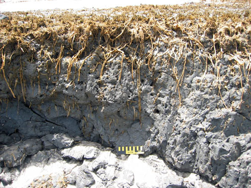
Just to oversimplify matters, but to assure that you get the big picture, the flow of matter and energy goes like this. Smooth cordgrass is the primary producer of organic material in the salt marshes, converting sunlight into food for it and, as it turns out, lots of other organisms. This is relatively easy for these plants because they are powered by intense Georgia sunlight much of the year. Smooth cordgrass also has extensive and complicated root systems, which help to hold most of the marsh muds in place when marshes are flushed by the tides. These roots locally change the chemistry of the surrounding mud and otherwise leave visible traces of their deeply penetrating networks, which are noticeable long after the plants had died and decayed.

Cross-section of a relict salt marsh preserved on Sapelo Island, Georgia, buried for about 500 years but just now being exhumed by shoreline erosion. See how deeply those roots of smooth cordgrass (Spartina alterniflora) penetrate the mud and still hold it in place? Modern ones do the same thing. Scale = 15 cm (6 in).

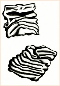
What produces the mud in a marsh? Mostly the ribbed mussels, oysters, and similar suspension-feeding animals, which: suck in water made cloudy by suspended clays; consume any useful organics that might be in that water; and excrete massive amounts of mud-filled feces, packaged with mucous as sand-sized particles. The oysters, along with cordgrass roots, stabilize the banks of tidal creeks, keeping these from washing away with each ebb tide.

If you’ve ever wondered what ribbed mussel (Geukensia demissa) feces look like, you’re in luck. Each one is only about 1 millimeter (0.04 inches) across, which makes them behave more like sand instead of much tinier clay particles. Also think of them as little packets of mud shrink-wrapped by mucous. Illustration by Anthony Martin, based on a figure by Smith and Frey (1985).

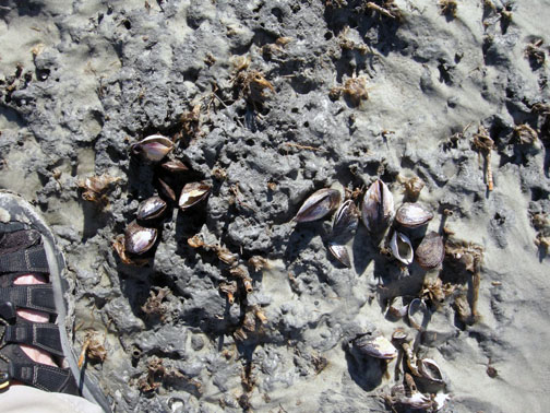
A view of what used to be a marsh surface – the relict marsh on Sapelo Island, that is – with stubs of long-dead smooth cordgrass accompanied by equally long-dead clusters of ribbed mussels (Geukensia demissa). Back in the day (about 500 years ago), these mussels were happily pumping out mud-filled feces, and their modern descendants are still doing the same thing. Sandal (left) is size 8½ (mens). Photograph by Anthony Martin.

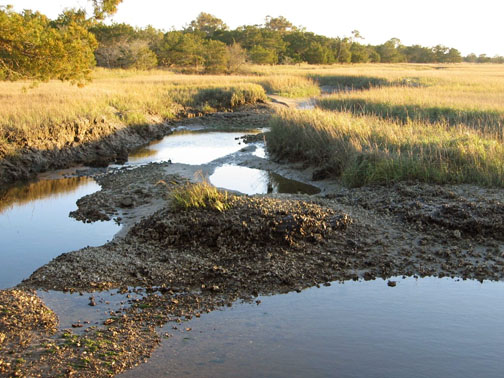
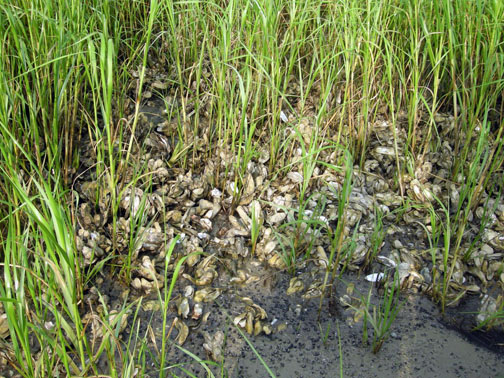
Prominent clumps of eastern oysters (Crassostrea virginica), exposed at low tide in the middle of a tidal creek on Sapelo Island. These not only help to produce mud, but keep it in place, while also slowing down flow and helping to deposit mud. Photograph by Anthony Martin.

A close-up look at more oysters surrounded by smooth cordgrass, with both working together to bind and accumulate mud on Sapelo Island. Now that’s ecological teamwork! Photograph by Anthony Martin.

Both the cordgrass and oysters also baffle and otherwise slow down the water flow, causing mud – fecal or otherwise – to get deposited. In short, a Georgia salt marsh with its thick deposits of beautifully dark, rich, gooey mud, much of which consists of the traces of mussels and oysters, would cease to exist without these bivalves and smooth cordgrass, and would become more like an open lagoon.

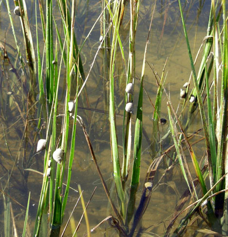
Meanwhile, marsh periwinkles are constantly moving up and down the stalks and leaves of the smooth cordgrass, grazing on algae growing on the cordgrass. This activity causes visible damage to the plants, tearing them into small bits and pieces that fall onto the marsh surface.

Marsh periwinkles (Littoraria irrorata) doing what they do best, which is graze on the stalks and leaves of smooth cordgrass, leaving many traces from damaging these plants while also contributing plant debris to the marsh surface. Photograph by Anthony Martin, taken on Sapelo Island.

Fungi and bacteria further break down this “gentle rain from heaven” of cordgrass debris once it reaches the marsh surface. Here, mud fiddler crabs consume this stuff, along with any algae that might be growing on marsh surfaces. Their scrape marks and discarded balls of processed sediment are everywhere to be seen on the marsh surface and add to the sediment load of a marsh. Furthermore, as we may have learned in grade school, all animals poop, so in this way these fiddler crabs and other species of crabs living in the salt marshes donate even more enriched organic material. They also dig millions of burrows, some adorned by prominently pelleted turrets, churning the uppermost part of the marsh mud like earthworms would do to a soil in a forest or field.

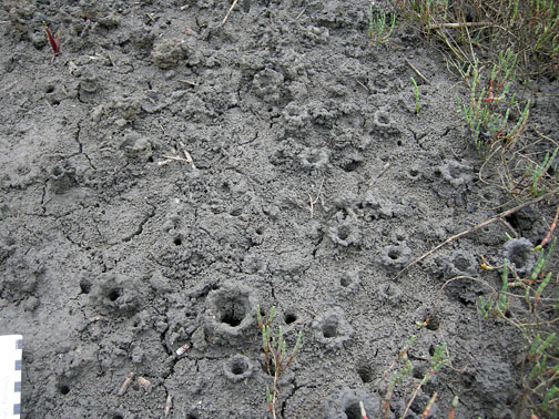
Mud fiddler crabs (Uca pugnax) and their many traces on a salt marsh surface, including feeding pellets, scrape marks, and burrows. Photo by Anthony Martin, taken on Sapelo Island.

Mud-fiddler crab burrows exposed at low tide in a marsh, many with pellet-lined turrets. Why do they make these structures? Good question, which I’ll try to answer in the future. Photo by Anthony Martin, taken on Sapelo Island.

Hence you cannot go to a Georgia salt marsh and say, “I can’t see any traces,” unless you are closing your eyes or are otherwise sight deprived. The entire salt marsh is composed of traces, and these traces, which are the products of plant and animal behavior, actually control the ecology of the salt marshes. Thus I often refer to Georgia salt marshes as examples of “ichnological landscapes,” places that are the sum of all traces. This concept then better prepares us for viewing these and other Georgia coastal environments as places where geologists can begin to understand how organisms can leave their marks – both big and small – in the geologic record.

Further Reading:

Craige, B.J. 2001. Eugene Odum: Ecosystem Ecologist and Environmentalist. University of Georgia Press, Athens, Georgia: 226 p.

Odum, E.P. 1968. Energy flow in ecosystems; a historical review. American Zoologist, 8: 11-18.

Odum, E.P., and Smalley, A.E. 1959. Comparison of population energy flow of a herbivorous and a deposit-feeding invertebrate in a salt marsh ecosystem. Proceedings of the National Academy of Sciences, 45: 617-622.

Smith, J.M., and Frey, R.W. 1985. Biodeposition by the ribbed mussel Geukensia demissa in a salt marsh, Sapelo Island, Georgia. Journal of Sedimentary Research, 55: 817-825.

Teal, J.M. 1962. Energy flow in the salt marsh ecosystem of Georgia. Ecology, 43: 614-624.

Teal, J.M., and Teal, M. 1983. Life and Death of a Salt Marsh. Random House, New York: 274 p.

Teal, M., and Teal, J.M. 1964. Portrait of an Island. Atheneum, New York: 167 p. [reprinted by University of Georgia Press in 1997, 184 p.]

Why Study Traces in Georgia? A Celebration of the Familiar

For those of us who live in Georgia, we either forget or don’t know about the ecological and geological specialness of this part of the U.S. For example, my undergraduate students here in Atlanta often talk dreamily about their desire to visit the Amazon River basin, Costa Rica, Kenya, Australia, or other places far removed from Georgia, beguiled as they are by the exotic “other” qualities of those places with their biota and landscapes. On the other hand, almost none of these students have been to the Okefenokee Swamp, the Blue Ridge Mountains, the Cumberland Plateau, the long-leaf pine forests of Ichauway, or the Georgia barrier islands, unless my colleagues or I have taken them there on field trips. Yet these places, especially those with freshwater ecosystems, collectively hold a biodiversity nearly matching that of the Amazon River basin, an evolutionary consequence of the long geologic history of the Appalachian Mountains.

To be fair, I have likewise found myself succumbing to such place-based deflection and lack of appreciation for what is more-or-less in my backyard. In 2001, I realized that I had been to Brazil (three times) more often than Fernbank Forest (two times), even though Fernbank was only a five-minute bicycle ride from home in Decatur, Georgia. This imbalance was soon corrected, though, and many visits later, I learned to appreciate how this old-growth southern Appalachian forest in the middle of metropolitan Atlanta is a gem of biodiversity, every native species of plant and animal a facet testifying to their long evolutionary histories. Still, I wonder why we often ignore what is nearby, even if it is extraordinary?

Related to this quandary is one of the most common questions I encountered from friends, family, and colleagues while writing my book – Life Traces of the Georgia Coast – which was, “Why are you, a paleontologist and geologist, writing about the traces of modern plants and animals in Georgia?” This is a legitimate inquiry, but my answer surprises most people. I tell them that my main reason for staying here in Georgia to study the tracks, trails, burrows, nests, and other traces of its barrier islands is because these traces and their islands are world-class and world-famous. This high quality is directly linked to the biodiversity of the Georgia barrier islands, but also their unique geological histories compared to other barrier-island systems. Furthermore, these islands have inspired more than a few major scientific discoveries related to modern ecology and geology, some of which, made nearly 50 years ago, are still applicable to diagnosing the fossil record and the earth’s geologic history. In short, the Georgia barrier islands and their traces also reflect a legacy recognized by scientists far outside the confines of Georgia.

How so? I’ll explain in upcoming posts, and hope to demonstrate how the marvelous ecosystems of the Georgia coast and its geological processes are the proverbial gift that keeps on giving, continually helping us to better understanding the earth’s geologic past. Now that’s special!

Burrows at dawn: a partial view of the thousands of ghost-shrimp burrows dotting a Georgia beach at low tide, their entrances looking like tiny volcanoes. What makes these burrows so important, scientifically speaking, and why are they something that would cause scientists from outside of Georgia to travel and see in person? Photo by Anthony Martin and taken on Sapelo Island, Georgia.

Welcome to Life Traces of the Georgia Coast

Have you ever walked along a Georgia beach and noticed the broken shell of a clam lying on the sand, its owner still barely alive, and with no tracks or other signs near its body? How did it get there, and what could have caused this clam to end up like this? How could you find more clues to figure out what happened?

You take a few more steps along this beach, and you see tiny, pinpoint-like tracks on the beach in sets of four that form a V-shaped pattern. Some of these start at the surf and lead to small, circular holes in the coastal dunes. These holes have streaks of sand radiating outward, or pyramids formed by regularly sized and carefully stacked balls of sand. Would you be surprised to know that the same animal makes all of these traces? What animal was it, and what was it doing?

Insect Trail: Cumberland Island

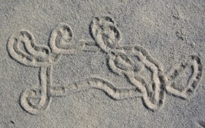
Insect Trail: Cumberland Island, photo by Anthony Martin

Near these holes, you also spot a meandering, looping squiggle in a dune, looking as if a child dragged her finger through the sand, yet with no footprints around it. Your eyes and mind now properly tuned, you see many more of these marks, along with shallow tunnels, some less than the width of a pencil but others much larger, looking like buried pipes. These disturb the otherwise smooth surfaces of the dunes, as do many animal tracks of various shapes, forming distinctive patterns. What made these traces and what do they tell us about unseen life under and on the dunes?

A hike in the forest of that same island reveals more mysteries: tracks of many sizes and forms, criss-crossing trails, dig marks, holes in tree trunks, piles of feathers, small tunnels and shafts, and other such oddities, with nary an animal in sight. With your senses attuned to your surrounding, all of these are noticeable during less than 15 minutes of slow walking. Applying this newly found awareness, you then look at the mudflats of a nearby salt marsh. It likewise holds many holes, miniature turrets, scratch marks, tracks, droppings, and trails. Who made these traces, what do they mean, and how do scientists study them?

Welcome to ichnology, the study of modern and fossil traces made by plants and animals in their daily lives, a science that opens your eyes and mind to a world of unseen behavior. My upcoming book, Life Traces of the Georgia Coast (Indiana University Press) looks at the ichnology of a specific place – the Georgia barrier islands – and its themes will be explored further through this blog.

Each chapter in the book begins with a story about traces on a Georgia barrier island, followed by tips about how to interpret these, especially how they relate to behavior. But Life Traces of the Georgia Coast also tells readers how paleontologists diagnose similar behaviors of the ancient past through their study of trace fossils, which are fossilized tracks, trails, burrows, nests, and other traces. Making this connection between the present and the past is an example of a basic principle of geology, called uniformitarianism, or, if you prefer using fewer syllables, actualism. The main theme of the book, then, is to show how the study of one place (the Georgia barrier islands) is filled with a wide variety of ecosystems, plants, and animals, which through their traces can provide a window into our interpreting the past.

Life Traces of the Georgia Coast is filled with lots of my enthusiasm and humor, which I hope is appreciated. But I generously illustrated it with my original artwork and photographs, so if you ever get bored reading it, you can always look at the pictures. I hope to do the same with this blog, teaching through my observations of natural phenomena on the Georgia barrier islands – usually conveyed through photographs and descriptions – and asking questions about what can be observed and from the everyday traces made on those islands. And because more than a million people visit the Georgia coast every year, there’s a good chance you may be one of those people, and that you will see traces that catch your attention, pique your curiosity, and ignite your sense of wonder. Get ready to explore, discover, and learn.