This past weekend, my colleague Steve Henderson and I co-led a field trip to Sapelo Island, Georgia with 13 Emory University undergraduate students and our spouses. This trip is done biannually as a firm requirement for students taking a class of mine at Emory called Modern and Ancient Tropical Environments. This course, in turn, is a prerequisite for a 10-day field course we’ll do in December-January, ENVS 242, which appropriately has the same name as ENVS 241 except for the addition of “Field Course” at the end. That course, though, will take place on another island, albeit a very different one, San Salvador, one of the “Out Islands” of the Bahamas.
Why were we on Sapelo Island to prepare for a field course in the Bahamas? It was to fulfill several learning goals that will sound familiar to all science educators who take their students outside of a classroom for their learning. In no particular order, these are:
- Get students to observe natural phenomena while in the field;
- Ask good questions about what they’ve observed;
- Learn how to properly record their observations;
- Come up with explanations (hypotheses) for whatever questions were provoked by their field experiences; and
- Staying safe while doing all of this, which included adjusting to whatever conditions we might encounter in the field.
Our spouses, Ruth Schowalter and Kitty Henderson, are also educators; Ruth teaches English as a Second Language (ESL) at Georgia Tech, and Kitty is a middle-school earth-science teacher in Covington, Georgia. Moreover, both have been to Sapelo Island many times, having gained a wealth of field-gained knowledge about its natural history. Hence our students were lucky to have all four of us there to introduce them to the island, and we likewise felt very fortunate to be there with such an eager group on a gorgeous fall weekend.
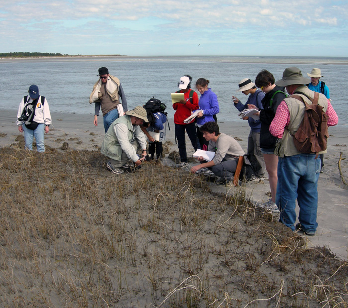 Environmental Studies students from Emory Univeristy with me (foreground) and Steve Henderson (right), looking at a 500-year-old relict salt marsh, exposed by erosion along Cabretta Beach on Sapelo Island, Georgia. Sure beats staying in a classroom to learn about modern and ancient environments. (Photograph by Ruth Schowalter.)
Of course, once on Sapelo or any other barrier island of the Georgia coast, I cannot help but use ichnology – the study of traces – as a uniting theme for my teaching. Steve, who did his Ph.D. research on Sapelo in the late 1970s, is more of a taphonomist, which is someone who studies how fossils are made, from death to burial to preservation. Nonetheless, ichnology and taphonomy overlap considerably, hence our respective approaches complement one another very well, a synergism aided by our having had the same Ph.D. advisor – Robert (Bob) Frey – at the University of Georgia. Once in the field, every track, burrow, feces, and body part of a dead animal we found – and the occasionally sighted live animal – became a dynamic learning opportunity for us, in which we could apply basic scientific methods that were all accented by a sense of wonder.
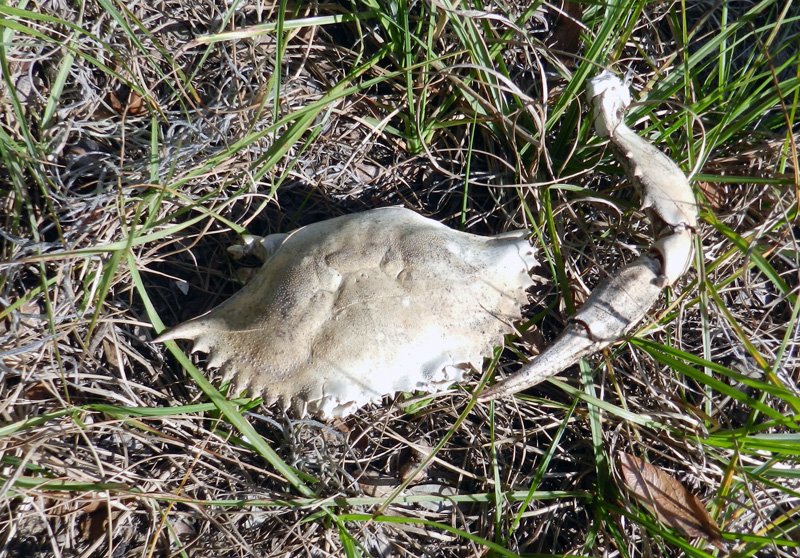 A dead blue crab (Callinectes sapidus) found in the middle of Sapelo Island, at least 2 kilometers (1.2 miles) from the ocean. How did it get there, and what happened to it? Our students went through the possibilities based on the evidence – main body nearly entire, no toothmarks on it, but bleached white and missing most legs. We finally concluded that it had been dropped by a large predatory bird, such as a great blue heron (Ardea herodias) or great egret (Ardea alba), which probably had shaken off most of the crab’s legs before attempting to eat it. A nice little lesson in taphonomy, for sure. (Photograph by Anthony Martin.)
But perhaps my favorite teaching techniques to use while on Sapelo or any other Georgia barrier island is to use the completely low-tech and ancient method of drawing in the sand. Through my own traces, then, I can teach my students about ichnology and its applications to understanding geologic processes. For example, one of the beaches on Sapelo – Cabretta Beach – is undergoing rapid erosion from a combination of longshore drift and sea-level rise. At this place, downed pines and oaks laid prone in the surf, a former forest now a beach. This was the perfect place to introduce the students to Walther’s Law, which states that laterally adjacent environments will succeed one another vertically in the geologic record. This principle then can be applied to figuring out how a given sequence of strata might reflect a rising or lowering of sea level in the past.
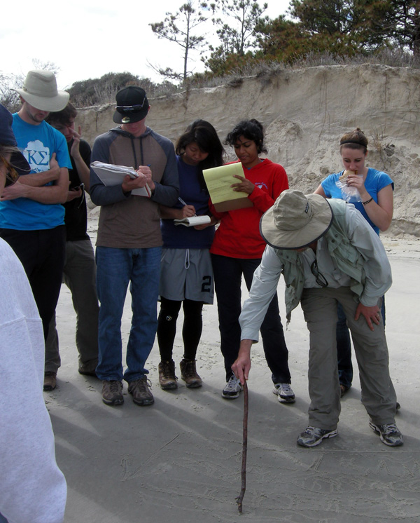 No PowerPoint? No projector? No computer? No problem. Teaching in the field is easy when you have such a nice canvas to work with. (Photograph by Ruth Schowalter.)
So with the sea behind me, a sandy beach wiped clean by the receding tide, and a handy stick, I scratched out a typical sequence of sedimentary strata and their diagnostic traces that would result from sea level going up (a transgression) on the Georgia coast. (Ruth and I were also inspired to create artwork on this theme, discussed in a previous entry.) Terrestrial environments with tree-root and insect traces were at the base of the sequence, succeeded vertically by sandy dune deposits with ghost-crab and insect burrows, then sandy beach deposits with ghost-shrimp burrows, topped off by offshore sandy muds and sands burrowed by fully marine echinoderms, such as heart urchins, sea stars, and brittle stars. I then asked the students to look around them and point to each of the laterally adjacent environments represented in my sand drawing, which they dutifully did. Finally, just to make sure our students got it, we inquired about what sequence should result if sea level dropped, and they correctly surmised that the place would revert back to terrestrial conditions, with the marine sediments buried below.
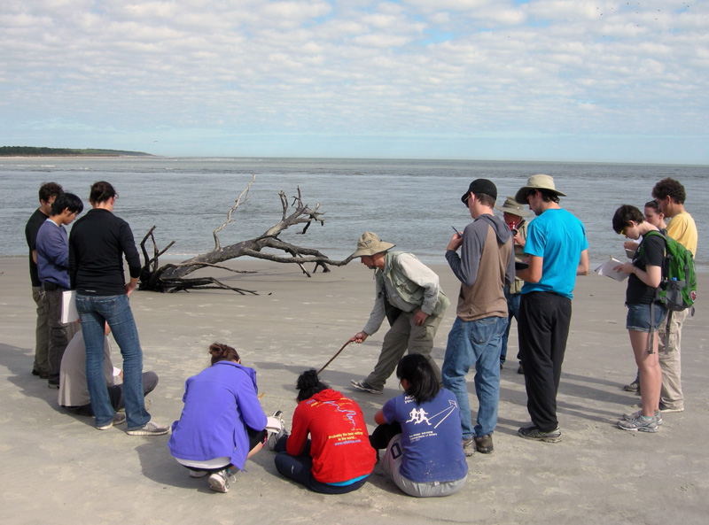 My applying the final touches on a sand-sketch masterpiece of a transgressive-regressive sequence of strata and its traces, as my students watch. Would you like to see it? Sorry, the tide came in just a few hours after I drew it, and we didn’t get a photo of it. So you’ll just have to draw your own, and preferably on a beautiful beach. (Photograph by Ruth Schowalter.)
As we all stood back to look at the transgressive-regressive sequence of strata, the formerly abstract concept of Walther’s Law became far more real for our students. The dead trees on either side of our group, an eroded dune and maritime forest behind us, and the sea in front of us, all reinforced this lesson, bolstered by our presence in a place with those environments being actively affected by geological and biological processes.
Another instance of using traces in the sand to teach about traces was with ghost-shrimp burrows. At low tide on the previous day of the field trip, the students found many small, volcano-like mounds on the intertidal beach surface some with neat piles of tiny mud-filled cylinders that looked like “chocolate sprinkles” sometimes seen on cupcakes. What were these?
I informed them that we were looking at the tops of ghost-shrimp burrows and their fecal pellets; earlier, we had seen the knobby, pelleted walls of these same ghost-shrimp burrows, which were the deeper parts. What does an entire ghost-shrimp burrow system look like in cross-section? Time for another sand drawing. This one introduced the students to what had been only disembodied words memorized for an exam – ghost shrimp, pellets, walls, vertical shafts, branching – that now could be supplemented by actual traces next to the drawing. You can’t beat these sorts of visual aids, a huge bonus from our being in the right places to see them.
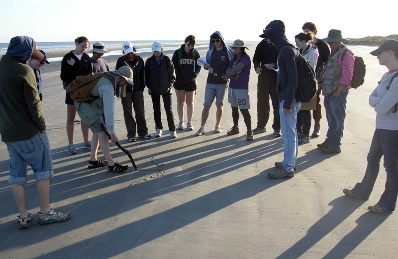 Using a “clean slate” of a beach wiped smooth by the tide for sketching a cross-section of a typical ghost-shrimp burrow, many of which also happened to be underneath our feet. (Photograph by Ruth Schowalter.)
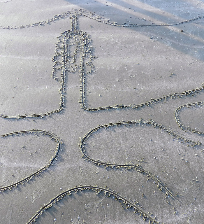 The final sketch of a ghost-shrimp burrow, showing its volcano-like top, narrow “chimney” leading down to the main shaft of the shrimp’s living chamber, some of the pellets lining its burrow walls, and the geometry of the burrow network below. (Photograph by Anthony Martin.)
Was my teaching technique new and innovative, worth presenting at an educational conference as an assessment-friendly pedagogy that would maximize outcome-based education? In short, no. Sand drawing as a tool for education has a very long tradition in indigenous cultures, especially those that have their own forms of ichnology (such as tracking) at their cores. For example, in central Australia, Ruth and I had seen a creation story etched in the ground that had been done some by the Arrente people who live near Uluru. This story likewise used animal traces (emu tracks) as a key feature, a sort of iterative use of traces for inspiration and teaching.
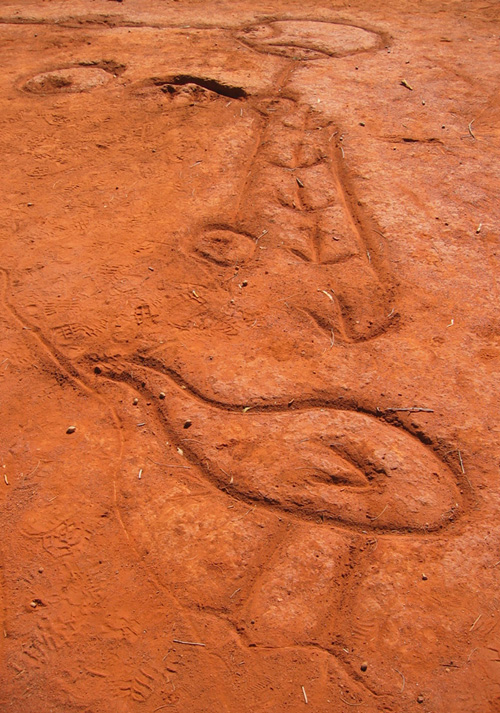 Creation story of the Arrente people drawn in the soil near Uluru in Northern Territory, Australia. The figure at the bottom is an emu, and its tracks are shown leading away from it. (Photograph by Anthony Martin.)
At the same place, we also watched an Arrente elder demonstrate how to make animal tracks using only his fingers and palms, which was also described in books we had read about
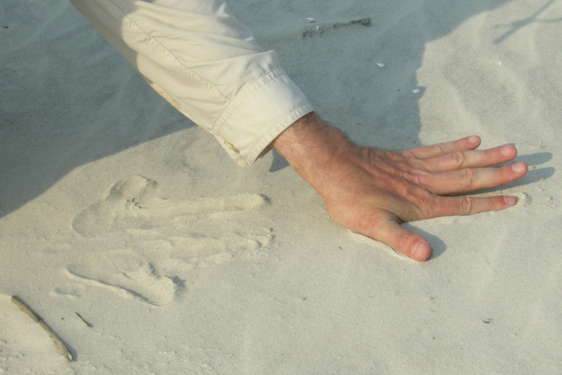 Did you know you can use your hands to make animal tracks? In this photo, I use the fine-grained dune sands of Sapelo Island to create a reasonable depiction of kangaroo tracks. Yes, I know, kangaroo tracks on the Georgia barrier islands are not very likely, but you get the idea. Next time I’ll do raccoon tracks instead.
Some of us educators are old enough to remember using a technological succession of blackboards and chalk, overhead projectors with pens, whiteboards with dry-erase pens, and now presentation software (Keynote, PowerPoint, and so on) for imparting lessons. So it gives me great comfort to know that, with a generation of students who have never known a world without computers with a concomitantly reduced connection to the outdoors, we can still switch back to using the ground beneath our feet, our eyes, hands, and imaginations to teach and learn about the life traces around us.
Further Reading
Bingham, J. 2005. Aboriginal Art and Culture. Raintree, Chicago, Illinois: 57 p.
Hoyt, J.H., and Hails, J.R. 1967. Pleistocene shoreline sediments in coastal Georgia: deposition and modification. Science, 155: 1541-1543.
Hoyt, J.H., Weimer, R.J., and Henry, V.J., Jr. 1964. Late Pleistocene and recent sedimentation on the central Georgia coast, U.S.A. In van Straaten, L.M.J.U. (editor), Deltaic and Shallow Marine Deposits, Developments in Sedimentology I. Elsevier, Amsterdam: 170-176.
Louv, R. 2005. Last Child in the Woods: Saving Our Children from Nature-Deficit Disorder. Algonquin Books, Chapel Hill, North Carolina: 390 p.
Middleton, G.V. 1973. Johannes Walther’s Law of the Correlation of Facies. GSA Bulletin, 84: 979-988.
Weimer, R.J., and Hoyt, J.H. 1964. Burrows of Callianassa major Say, geologic indicators of littoral and shallow neritic environments. Journal of Paleontology, 38: 761-767.
