Despite more than 15 years of visiting the Georgia coast, studying its traces, and taking students on field trips to its barrier islands, I always marvel at how each trip is different, bestowing new insights and lessons to both me and my students. So a trip there this past weekend was no exception, and perhaps the most intriguing phenomenon I encountered during it was of some “mere” scrapings in a sandy road on Wassaw Island, Georgia.
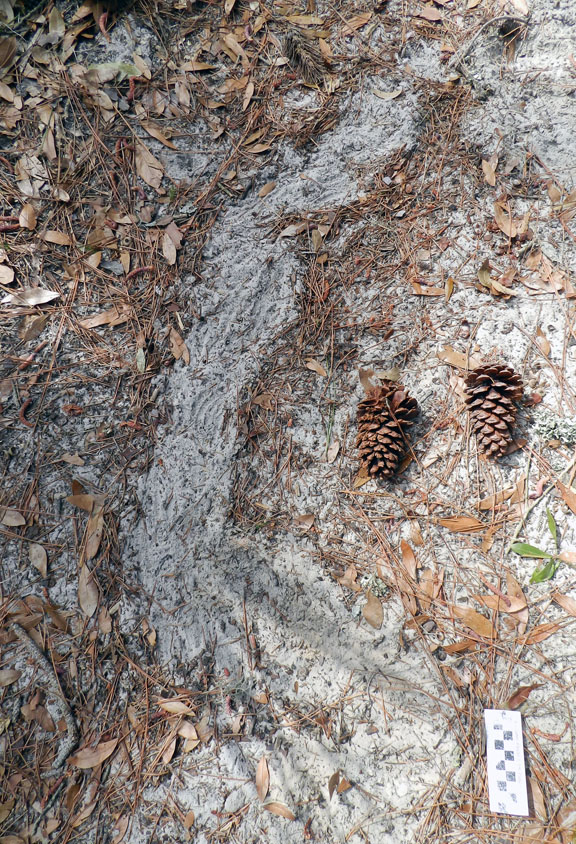
 Who needs a Mystery Date when you can have a Mystery Trace? Here we have some enigmatic scrapings in a sandy road on Wassaw Island, Georgia. What could have made these, and why? (Photograph by Anthony Martin; scale in centimeters.)
Wassaw Island is a National Wildlife Refuge, and I’ve mentioned it before as the one island of the Georgia coast that most closely approaches the ideal of “pristine,” a label blithely applied to nearly any Georgia barrier island regardless of how much humans had modified their landscapes. Current estimates are that it Wassaw only about 600 years old, which means that Native Americans had barely populated it by the time the Spanish arrived in the 16th century. Thus whenever I teach my biannual Barrier Islands class, I like to include a field trip to Wassaw Island so my students can appreciate the close-to-natural state of its ecosystems. We then contrast their experiences there by visiting overdeveloped Tybee Island on the same weekend, giving my students the opportunity to think about “before and after” conditions of Georgia barrier-island ecosystems.
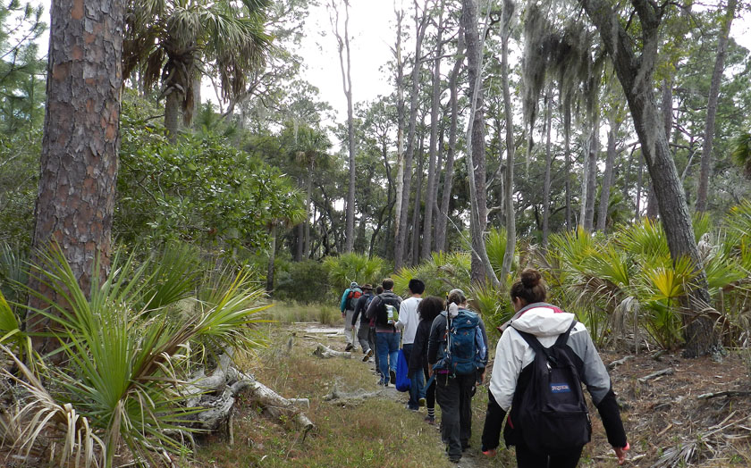
Even better for my students, our leader for the field trip to Wassaw was not me, but John “(“Crawfish”) Crawford, one of the most knowledgeable naturalists on the Georgia coast. Employed by the University of Georgia Marine Extension Service on Skidaway Island, John regularly takes groups on an open boat to Wassaw Island for day trips. These trips never disappoint for the sheer variety and richness of natural history learned along the way, whether on the boat trip there and back, or on the island itself. I’ve been to Wassaw four times with John as a guide, and each time with him have seen something novel there. (I mean, how often do you see a decapitated seagull?)
 Into the Woods, Wassaw Island style! With our intrepid guide (John “Crawfish” Crawford) leading the way into the maritime forest of Wassaw, my students were in for a world of discovery on this beautiful Georgia barrier island. (Photograph by Anthony Martin.)
Just one example from this most recent trip I’d like to share are traces I have never before seen, or, more likely, never before noticed. We encountered it while walking down a sandy road on Wassaw used more often by deer and alligators than humans. The traces were systematic and widespread scrapings of the top few centimeters of the road, some of which resolved themselves as curved to linear features with finer grooves in their interiors. Because they did not match the feeding traces of feral hogs (Sus scrofa) or nine-banded armadillos (Dasypus novemcinctus), I was intrigued. Who made these, and why?
 Just in case you missed it the first time, here’s that photo again. Yes, this will be on the exam: why do you even ask?
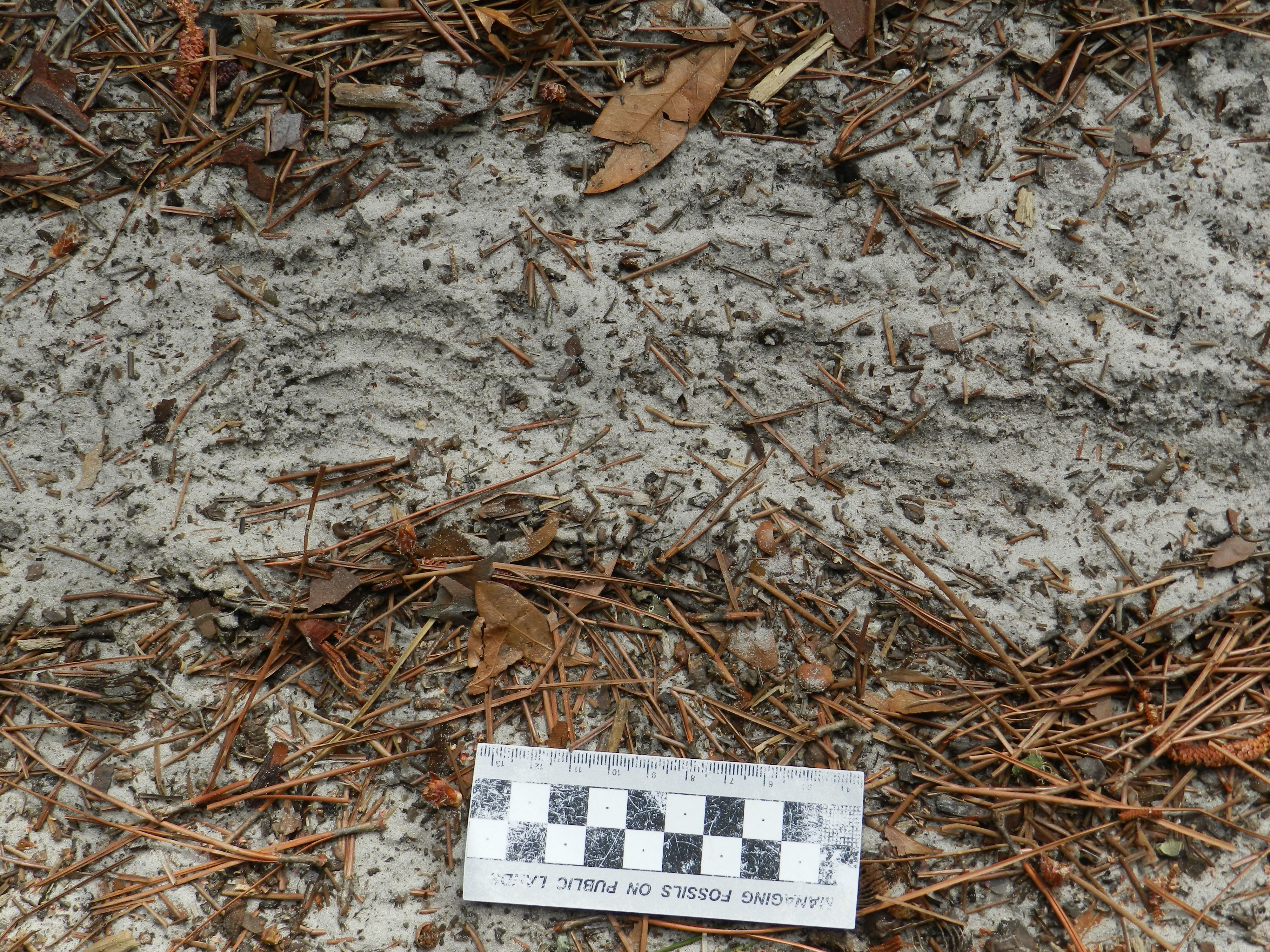
A closer look revealed the traces were overlapping sets pf five evenly spaced grooves, corresponding with five thin-fingered hands. These could only belong to the most dextrous, industrious, and resourceful denizens of maritime forests and other environments on the Georgia coast, raccoons (Procyon lotor). When I queried John about these traces, he confirmed that not only were they made by raccoons, but also were a result of their “mining” the sand. The raccoons, using their front paws, methodically raked the loose sand to expose shallowly buried acorns dropped by the many old and mighty oaks lining the road, indulging in an all-you-can-eat acorn feast.
 Close-up of the same mystery trace seen in the previous photo, but this time more groovy. Check out the curving, parallel set of five grooves (left) and the partial track (right), telling us that a masked bandit left its mark. (Photograph by Anthony Martin; scale in centimeters.)
Although raccoons are infamously omnivorous, in winter months they depend on acorns for much of their diet. Thus considering that the Georgia coast was still in winter, and that a sub-freezing cold front had just passed through the area a few days before, it was not surprising to see this evidence of extensive acorn foraging.
OK, time to replace my floppy coastal-geologist hat with my more stylish paleontologist hat to ask this question: Would such traces preserve in the geologic record, and if so, would they be recognizable for both the tracemaker (raccoon) and behavior (foraging)? Probably not for both, as the loose quartz-rich sand in a maritime forest would have few chances of being buried intact and cemented in a way that would “freeze” the details needed to discern both tracemaker and its intent. Yet these traces would lend some insights to interpreting disturbed zones in the upper parts of fossil soils, especially those that might have preserved acorns or other nuts in them.
So next time you’re in a maritime forest during the winter and come across some odd scrapings in the road, take a closer look and ask yourself a few questions about them. Who made them? Why did they make them? How do these traces relate to the broader ecology of the area? Would they be preserved in the fossil record, and if so, could we properly interpret them? Then ask yourself what you’ll find next time you go to the same place and look just a little bit closer.
