Into the Dragon’s Lair: Alligator Burrows as Traces

American alligators (Alligator mississippiensis) tend to provoke strong feelings in people, but the one I encounter the most often is awe, followed closely by fear. Both emotions are certainly justifiable, considering how alligators are not only the largest reptiles living on the Georgia barrier islands, but also are the top predators in both freshwater and salt-water ecosystems in and around those islands. I’ve even encountered them often enough in maritime forests of the islands to regard them as imposing predators in those ecosystems, too.
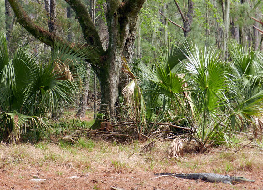
Time for a relaxing stroll through the maritime forest to revel in its majestic live oaks, languid Spanish moss, and ever-so-green saw palmettos. Say, does that log over there look a little odd to you? (Photo by Anthony Martin, taken on St. Catherines Island.)

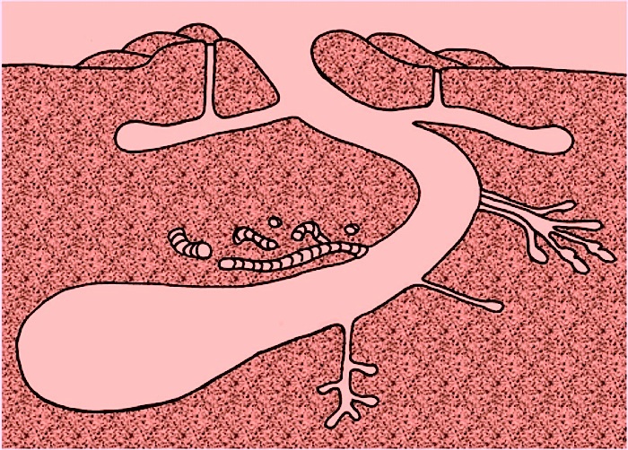
But what many people may not know about these Georgia alligators is that they burrow. I’m still a little murky on exactly how they burrow, but they do, and the tunnels of alligators, large and small, are woven throughout the interiors of many Georgia barrier islands. Earlier this week, I was on one of those islands – St. Catherines – having started a survey of alligator burrow locations, sizes, and ecological settings.
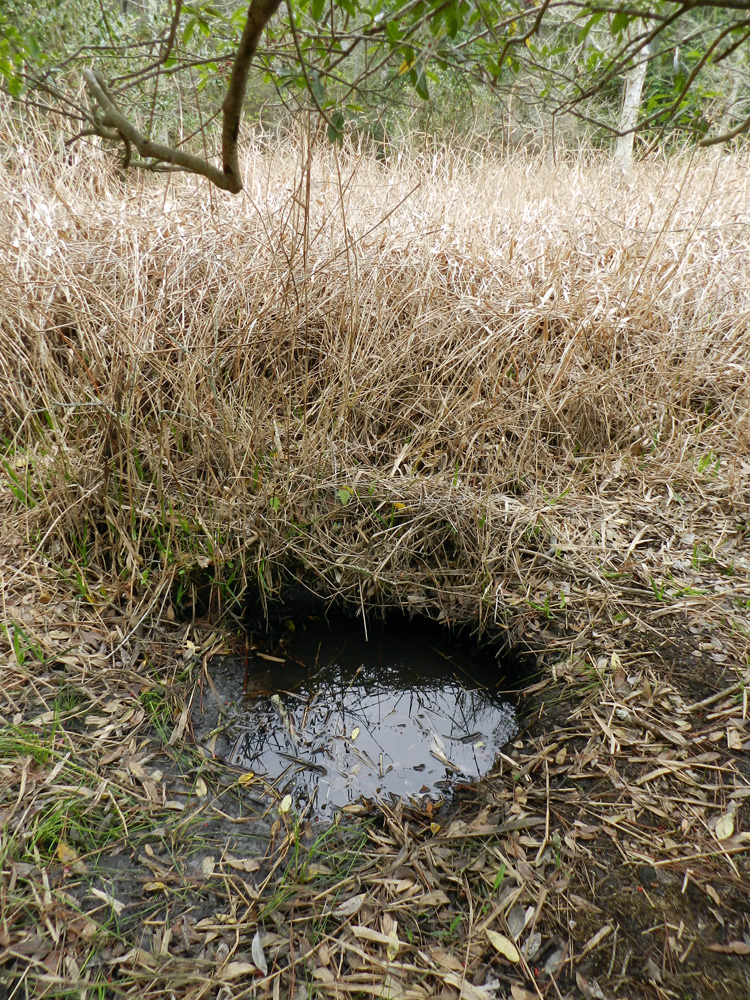
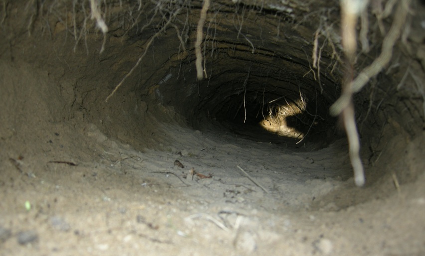
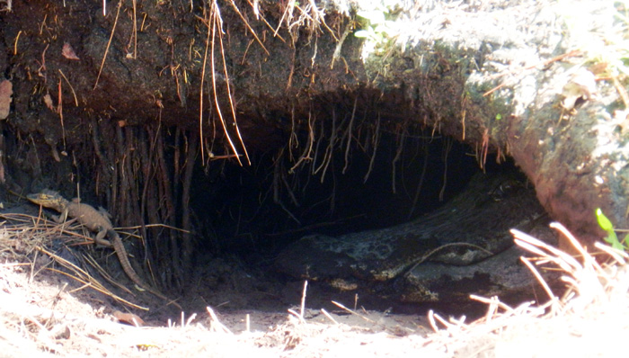
Entrance to an alligator burrow in a former freshwater marsh, now dry, yet the burrow is filled with water. How did water get into the burrow, and how does such traces help alligators to survive and thrive? Please read on. (Photograph by Anthony Martin and taken on St. Catherines Island, Georgia.)

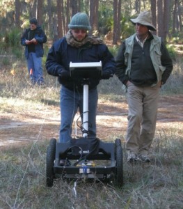
In this project, I’m working cooperatively (as opposed to antagonistically) with a colleague of mine at Emory University, Michael Page, as well as Sheldon Skaggs and Robert (Kelly) Vance of Georgia Southern University. As loyal readers may recall, Sheldon and Kelly worked with me on a study of gopher tortoise burrows, also done on St. Catherines Island, in which we combined field descriptions of the burrows with imaging provided by ground-penetrating radar (also known by its acronym, GPR). Hence this project represents “Phase 2” in our study of large reptile burrows there, which we expect will result in at least two peer-reviewed papers and several presentations at professional meetings later this year.

Why is a paleontologist (that would be me) looking at alligator burrows? Well, I’m very interested in how these modern burrows might help us to recognize and properly interpret similar fossil burrows. Considering that alligators and tortoises have lineages that stretch back into the Mesozoic Era, it’s exciting to think that through observations we make of their descendants, we could be witnessing evolutionary echoes of those legacies today.

Indeed, for many people, alligators evoke thoughts of those most famous of Mesozoic denizens – dinosaurs – an allusion that is not so farfetched, and not just because alligators are huge, scaly, and carnivorous. Alligators are also crocodilians, and crocodilians and dinosaurs (including birds) are archosaurs, having shared a common ancestor early in the Mesozoic. However, alligators are an evolutionarily distinct group of crocodilians that likely split from other crocodilians in the Late Jurassic or Early Cretaceous Period, an interpretation based on both fossils and calculated rates of molecular change in their lineages.
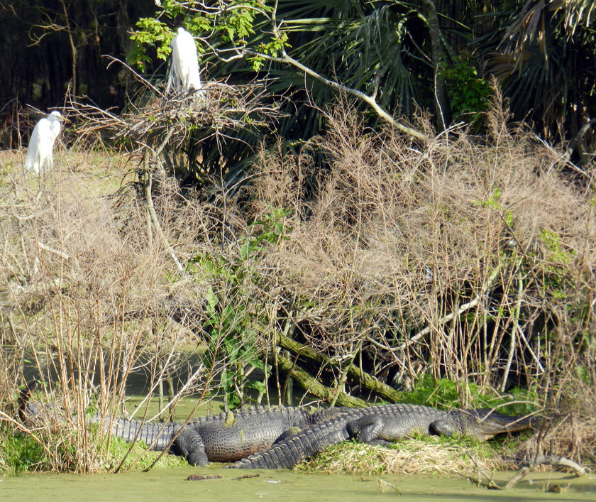
Archosaur relatives, reunited on the Georgia coast: great egrets (Ardea alba), which are modern dinosaurs, nesting above American alligators (Alligator mississippiensis), which only remind us of dinosaurs, but shared a common ancestor with them in the Mesozoic Era. (Photograph by Anthony Martin, taken on St. Catherines Island, Georgia.)

Along these lines, I was a coauthor on a paper that documented the only known burrowing dinosaurOryctodromeus cubicularis – from mid-Cretaceous rocks in Montana. In this discovery, we had bones of an adult and two half-grown juveniles in a burrow-like structure that matched the size of the adult. I also interpreted similar structures in Cretaceous rocks of Victoria, Australia as the oldest known dinosaur burrows. Sadly, these structures contained no bones, which of course make their interpretation as trace fossils more contentious. Nonetheless, I otherwise pointed out why such burrows would have been likely for small dinosaurs, especially in Australia, which was near the South Pole during the Cretaceous. At least a few of these reasons I gave in the published paper about these structures were inspired by what was known about alligator burrows.
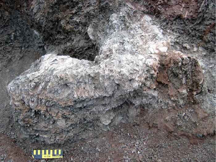
Natural sandstone cast of the burrow of the small ornithopod dinosaur, Oryctodromeus cubicularis, found in Late Cretaceous rocks of western Montana; scale = 15 cm (6 in). (Photograph by Anthony Martin, taken in Montana, USA.)
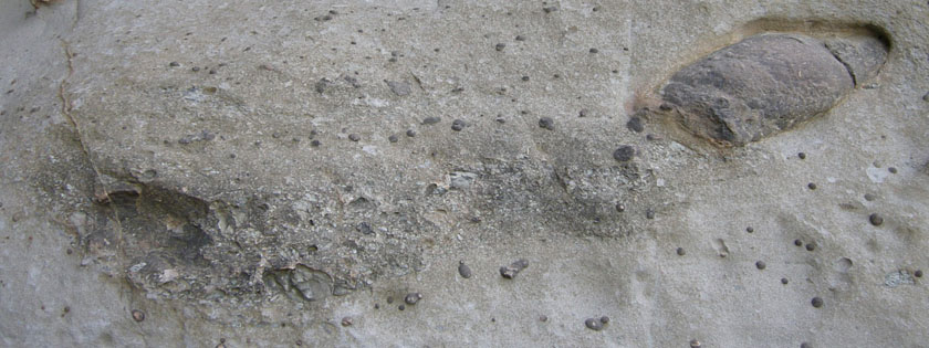
Enigmatic structure in Early Cretaceous rocks of Victoria, Australia, interpreted as a small dinosaur burrow. It was nearly identical in size (about 2 meters long) and form (gently dipping and spiraling tunnel) to the Montana dinosaur burrow. (Photograph by Anthony Martin, taken in Victoria, Australia.)

What are the purposes of modern alligator burrows? Here are four to think about:

Dens for Raising Young Alligators – Many of these burrows, like the burrow interpreted for the dinosaur Oryctodromeus, serve as dens for raising young. In such instances, these burrows are occupied by big momma ‘gators, who use them for keeping their newly hatched (and potentially vulnerable) offspring safe from other predators.

Two days ago, Michael and I experienced this behavioral trait in a memorable way while we documented burrow locations. As we walked along the edge of an old canal cutting through the forest, baby alligators, alarmed by our presence, began emitting high-pitched grunts. This then provoked a large alligator – their presumed mother – to enter the water. Her reaction effectively discouraged us from approaching the babies; indeed, we promptly increased our distance from them. (Our mommas didn’t raise no dumb kids.) So although we were hampered in finding out the exact location of this mother’s den, it was likely very close to where we first heard the grunting babies. I have also seen mother alligators on St. Catherines Island usher their little ones through a submerged den entrance, quickly followed by the mother turning around in the burrow and standing guard at the front door.
Oh, what an adorable little baby alligator! What’s that? You say your mother is a little over-protective? Oh. I see. I think I’ll be leaving now… (Photograph by Anthony Martin, taken on St. Catherines Island.)

Temperature Regulation – Sometimes large male alligators live by themselves in these burrows, like some sort of saurian bachelor pad. For male alligators on their own, these structures are important for maintaining equitable temperatures for these animals. Alligators, like other poikilothermic (“cold-blooded”) vertebrates, depend on their surrounding environments for controlling their body temperatures. Even south Georgia undergoes freezing conditions during the winter, and of course summers there can get brutally hot. Burrows neatly solve both problems, as these “indoor” environments, like caves, provide comfortable year-round living in a space that is neither too cold nor too hot, but just right. The burrowing ability of alligators thus makes them better adapted to colder climates than other crocodilians, such as the American crocodile (Crocodylus acutus), which does not make dwelling burrows and is restricted in the U.S. to the southern part of Florida.

Protection against Fires – Burrows protect their occupants against a common environmental hazard in the southeastern U.S., fire. This is an advantage of alligator burrows that I did not appreciate until only a few days ago while in the field on St. Catherines. Yesterday, the island manager (and long-time resident) of St. Catherines, Royce Hayes, took us to a spot where last July a fire raged through a mixed maritime forest-freshwater wetland that also has numerous alligator burrows. The day after the fire ended, he saw two pairs of alligator tracks in the ash, meaning that these animals survived the fire by seeking shelter, and further reported that at least one of these trackways led from a burrow. The idea that these burrows can keep alligators safe from fires makes sense, similar to how gopher tortoises can live long lives in fire-dominated long-leaf pine ecosystems.

An area in the southern part of St. Catherines Island, scorched by a fire last July, that is also a freshwater wetland inhabited by alligators with burrows. The burrow entrances are all under water right now, which would work out fine for their alligator occupants if another fire went through there tomorrow. (Photograph by Anthony Martin, taken on St. Catherines Island.)

• Protection against Droughts – Burrows also probably help alligators keep their skins moist during droughts. Because these burrows often intersect the local water table, alligators might continue to use them as homes even when the accompany surface-water body has dried up. We saw several examples of such burrows during the past few days, some of which were occupied by alligators, even though their adjacent water bodies were nearly dry.

For example, yesterday Michael and I, while scouting a few low-lying areas for either occupied or abandoned dens, saw a small alligator – only about a meter (3.3 ft) long – in a dry ditch cutting through the middle of a pine forest. Curious about where alligator’s burrow might be, we approached it to see where it would go. It ran into a partially buried drainage pipe under a sandy road, a handy temporary refuge from potentially threatening bipeds. Seeing no other opening on that side of the road, we then checked the other side of the road, and were pleasantly surprised to find a burrow entrance with standing water in it. This small alligator had made the best of its perilously dry conditions by digging down to water below the ground surface.
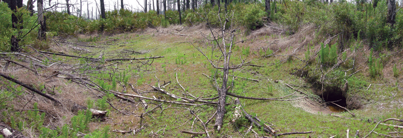
Alligator burrow (right) on the edge of a former water body. Notice how water is pooling in the front of the burrow, showing how it intersects the local water table. The entrance also had fresh alligator tracks and tail dragmarks at this entrance, showing that it was still occupied despite the lack of water outside of it. (Photograph by Anthony Martin, taken on Cumberland Island, Georgia.)
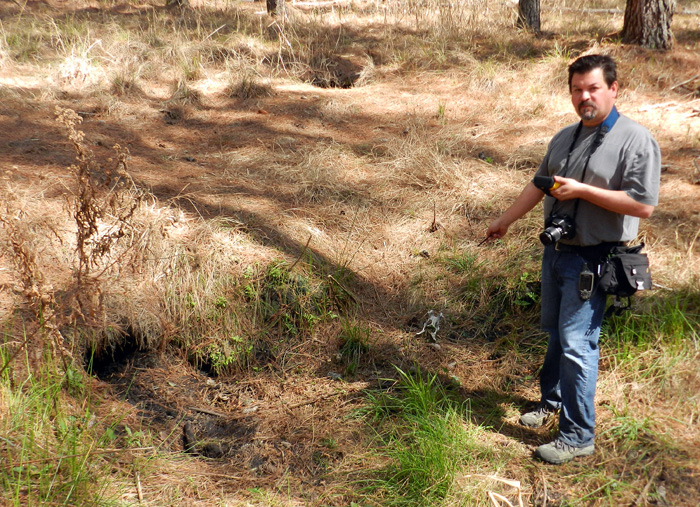
Alligator burrows (left foreground and middle background) in a maritime forest, also not associated with a wetland but marking the former location of one. Although the one to the left was unoccupied when we looked at it, it had standing water just below its entrance. This meant an alligator could have hung out in this burrow for a while after the wetland dried up, and it may have just recently departed. Also, once these burrows are high and dry, bones strewn about in front of them also add a delicious sense of dread. Here, Michael Page points at a deer pelvis, minus the rest of the deer. (Photograph by Anthony Martin, taken on St. Catherines Island, Georgia.)

What is especially interesting about the American alligator is how the only other species of modern alligator, A. sinensis in China, is also a fabulous burrower, digging long tunnels there too, which they use for similar purposes. This behavioral trait in two closely related but now geographically distant species implies a shared evolutionary heritage, in which burrowing provided an adaptive advantage for their ancestors.

Thus like many research problems in science, we won’t really know much more about alligator burrows until we gather information about them, test some of the questions and other ideas that emerge from our study, and otherwise do more in-depth (pun intended) research. Nonetheless, our all-too-short trip to St. Catherines Island this week gave us a good start in our ambitions to apply a comprehensive approach to studying alligator burrows. Through a combination of ground-penetrating radar, geographic information systems, geology, and old-fashioned (but time-tested) field observations, we are confident that by the end of our study, we will have a better understanding of how burrows have helped alligators adapt to their environments since the Mesozoic.

Juvenile alligators just outside two over-sized burrows, made and used by previous generations of older and much larger alligators. How might such burrows get preserved in the fossil record? How might we know whether these burrows were reused by younger members of the same species? Or, would we even recognize these as fossil burrows in the first place? All good questions, and all hopefully answerable by studying modern alligator burrows on the Georgia barrier islands. (Photograph by Anthony Martin, taken on Sapelo Island, Georgia.)

Further Reading

Erickson, G.M., et al. 2012. Insights into the ecology and evolutionary success of crocodilians revealed through bite-force and tooth-pressure experimentation. PLoS One, 7(3): doi:10.1371/journal.pone.0031781.

Martin, A.J. 2009. Dinosaur burrows in the Otway Group (Albian) of Victoria, Australia and their relation to Cretaceous polar environments. Cretaceous Research, 30: 1223-1237.

Martin, A.J., Skaggs, S., Vance, R.K., and Greco, V. 2011. Ground-penetrating radar investigation of gopher-tortoise burrows: refining the characterization of modern vertebrate burrows and associated commensal traces. Geological Society of America Abstracts with Programs, 43(5): 381.

St. John, J.A., et al., 2012. Sequencing three crocodilian genomes to illuminate the evolution of archosaurs and amniotes. Genome Biology, 13: 415.

Varricchio, D.J., Martin, A. J., and Katsura, Y. 2007. First trace and body fossil evidence of a burrowing, denning dinosaur. Proceedings of the Royal Society of London B, 274: 1361-1368.

Waters, D.G. 2008. Crocodlians. In Jensen, J.B., Camp, C.D., Gibbons, W., and Elliott, M.J. (editors), Amphibians and Reptiles of Georgia. University of Georgia Press, Athens, Georgia: 271-274.

Acknowledgements: Much appreciation is extended to the St. Catherines Island Foundation, which supported our use of their facilities and vehicles on St. Catherines this week, and Royce Hayes, who enthusiastically shared his extensive knowledge of alligator burrows. I also would like to thank my present colleagues and future co-authors – Michael Page, Sheldon Skaggs, and Kelly Vance – for their valued contributions to this ongoing research: we make a great team. Lastly, I’m grateful to my wife Ruth Schowalter for her assistance both in the field and at home. She’s stared down many an alligator burrow with me on multiple islands of the Georgia coast, which says something about her spousal support for this ongoing research.

Coquina Clams, Listening to and Riding the Waves

A little more than a week ago, I co-led a class field trip to Cumberland Island, Georgia and the nearby Okefenokee Swamp for a course titled Ecosystems of the Southeastern U.S. Although I had been to both places more than a few times, none of the students – and a few of my colleagues – had never visited either, potentially casting these already special places in a more exciting light for them.

Nonetheless, as is typical with any field trip to a Georgia barrier island, I also noticed new phenomena while on Cumberland, once again demonstrating how field trips with students ideally also cause the instructors to be filled with wide-eyed wonder. Even better, a few seemingly lowly small bivalves – coquina clams (Donax variabilis) – provided the intellectual highlight for me while we were on Cumberland Island. This is saying something for an island bearing charismatic livestock as a touristic draw.

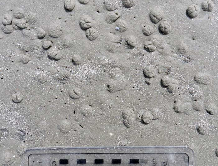
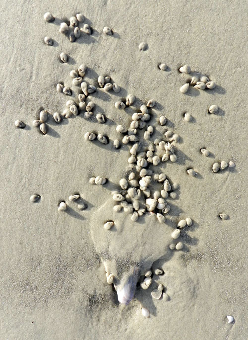
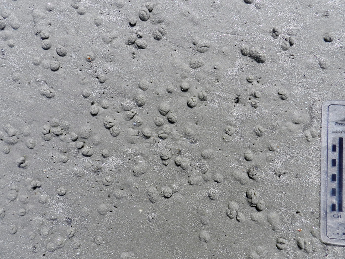
Resting traces (or are they escape traces?) of coquina clams (Donax variabilis) in the upper intertidal zone of a beach on Cumberland Island, Georgia. These clams are buried just underneath each bump of sand, but some others are much deeper and safer. How do I know that? You’ll find out. (Photograph by Anthony Martin.)

We first noticed the clams as a death assemblage just above the uppermost part of the surf zone on the beach. Their shells, some evident as single valves and others as pairs still hinged together, had been deposited by waves following a high tide, then moved slightly by the wind. These finely ribbed and polished shells readily showed why the specific name of coquina clams (D. variabilis) is applied to them, as they display a gorgeous variety of colors: yellow, orange, beige, blue, pink, and other schemes that surely would inspire interior decorators seeking paisley themes.
Coquina clams with both valves intact or apart, some partially covered by windblown sand, and variably colored. (Photo by Anthony Martin, taken on Cumberland Island, Georgia.)

Just a little bit lower on the beach and in the freshly scoured intertidal zone, we then noticed many small bumps of sand. Underneath these bumps were living clams that buried themselves, which helps to avoid drying out between tides or predation by ravenous shorebirds. With regard to the latter, these bivalves still would have been easy targets for shorebirds intent on acquiring some fresh clam snacks: think of a person ducking under a blanket to avoid being eaten by a lion and how well that might work as a tactic. (Please, just think about it and don’t actually test this idea.)

However, instead of simply writing off all coquina clams as inept burrowers who deserve to die at the beaks of their avian overlords – a similar fate experienced by dwarf surf clams (Mulinia lateralis) – we should look well below the surface, and I mean the sand surface. Look again at the photo first shown above. See all of those tiny, paired holes in between the bumps? Those are the traces of siphons from more deeply buried coquina clams, which are much more likely to escape from bivalve-munching birds while also keeping moist until the next high tide.

Here’s the same photo as above, but zoomed in so you can see the details. Did you notice all of the little holes in between shallowly buried clams? If so, bravo. If not, oh well. (Despite the cropping, turning, and otherwise shuffling electrons, this photograph is still by Anthony Martin, and was still taken on Cumberland Island.)

Coquina clams are actually accomplished burrowers, a necessary adaptation for nearly any small animal living in the high-energy surf of a Georgia beach. In the event of a wave breaking on a beach and washing away the top layer of sand, thus exposing a coquina clam, it will open its valves only enough to stick out its foot, which it then vibrates rapidly. This movement loosens the wet sand underneath, and the clam’s smooth, streamlined shell does the rest of the job, allowing it to glide into its self-made local pit of quicksand and vanish from the surface.
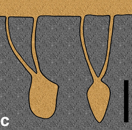
Once under the sand, this clam remains in a vertical position and projects its siphons upwards, making paired holes visible at the sand surface. The resulting burrow is Y-shaped, with the clam body making the lower part of the “Y” and the two siphons leaving thinner traces above. On the Cumberland Island beach the given day we observed their traces, I suspect the more deeply buried clams had the benefit of wetter sand early on as the tide dropped, then the ones hiding under mere caps of sand did the best they could with less wet sand later.

Vertical sections of the Y-shaped burrows made by a coquina clam, dwarf surf clam, or similar small, burrowing bivalves on the Georgia coast, in which the clam body is removed and sediment filled in the empty spaces from above. Both views, taken at right angles from one another, assume the clam is not moving up or down in the sand, which actually isn’t very realistic. (Illustration by Anthony Martin.)

How do we apply this knowledge to the fossil record? Paleontologists have found similar small, Y-shaped burrows in fine-grained sedimentary rocks, trace fossils named Polykladichnus. Some of these burrows are interpreted as the works of suspension-feeding bivalves, although polychaete worms or small arthropods are possible tracemakers, too. Where the lower parts of bivalves rested in sediment and left impressions of their lower halves, which were later filled by overlying sediments, are trace fossils called Lockeia. As a result, paleontologists can reliably identify a former presence of bivalves in rocks that might not have any of their shells. (By the way, please remember that trace fossil names are not the names of the bivalves that made the traces, but of the trace fossil itself. Yeah, I know, that’s confusing. But if you need more of an explanation, I have one for you here.)

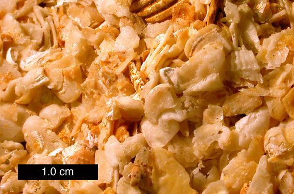
So what else is significant about coquina clams? Well, for one, their shells were abundant enough to have formed the framework for a loosely cemented limestone common in Florida, coquina limestone. This is a rock encountered by nearly anyone who has enjoyed (or suffered through) an introductory geology lab exercise on sedimentary rock identification. Students of mine have often compared these rock samples to popcorn balls or similar sugar-cemented treats, although I’ve noticed that no one has been tempted to eat them, no matter how long I kept them in lab that day.

Coquina limestone from Florida. Notice that some of the pieces are from other species of bivalves with rougher, corrugated shells, so these rocks are not made entirely of coquina clams. (Photograph by Mark Wilson of Wooster College, and taken from Wikipedia Commons here.)

But I saved the best tidbits of information for last, and something I’ll bet most people don’t know about these clams that makes them, like, totally cool. These little bivalves respond to sound and migrate seasonally. Yes, that’s right: these clams have their own form of “listening” and they can move en masse once the seasons change on the Georgia coast. Here’s how they do both:

Stop, Look, Listen – Of course, clams lack ears (although rumors still persist that they have legs). Thus they do not hear in the sense we do, but instead respond to low-frequency vibrations caused by waves striking the shore. Once these vibrations are detected, they react by: popping out of the sand; jumping up into the water; body surfing on the wave; and quickly reburying themselves in the sand once dumped by that same wave. Like some aficionados of heavy metal or punk rock, louder is better, as higher-decibel waves cause more clams to jump up out of the sand and into the water, an aquatic version of a molluscan mosh pit.

Shelled Migration – Coquina clams, like caribou, wildebeest, and arctic terns, migrate. Unlike the vast distances covered by those animals, though, coquina clams simply move up and down the slope of a beach with the changes of the seasons. Using their wave-surfing and burrowing abilities, they move from the lower intertidal zone – which is where they live during the spring, summer, and fall – to the upper part of the beach, which becomes their winter homes.

So I hope that all of this pondering over a few shells, bumps, and holes on a Cumberland Island beach has helped lend an appreciation for the small wonders on any given Georgia barrier island. Who knows what little discovery the next field trip will bring, or whether some facsimile of what is seen might also be preserved in the fossil record? As the old saying goes, time will tell, whether that time is in the present or the geologic past.

Further Reading

Ellers, O. 1995a. Discrimination among wave-generated sounds by a swash-riding clam. Biological Bulletin, 189: 128-137.

Ellers, O. 1995b. Behavioral control of swash-riding in the clam Donax variabilis. Biological Bulletin, 189: 120-127.

Pemberton, S.G., and Jones, B. 1988. Ichnology of the Pleistocene Ironshore Formation, Grand Cayman Island, British West Indies. Journal of Paleontology, 62: 495-505.

Ruppert, E.E., and Fox, R.S. 1988. Seashore Animals of the Southeast. University of South Carolina Press, Columbia, South Carolina: 429 p.

Turner, H.J., Jr., and Belding, D.L. 1957. The tidal migrations of Donax variabilis Say. Limnology and Oceanography, 2: 120-124.

Tracking the Wild Cattle of Sapelo Island

(The following is part of a series about traces of key invasive species of mammals on the Georgia barrier islands and the ecological effects of these traces. Here is an introduction to the topic from last month, and the first entry was about the feral horses of Cumberland Island.)

If I were pressed to name my favorite Georgia barrier island, it would be a tough choice, but it would be Sapelo. Many reasons support this preference, both practical and emotional, which I will relate before getting to the topic featured in the title.

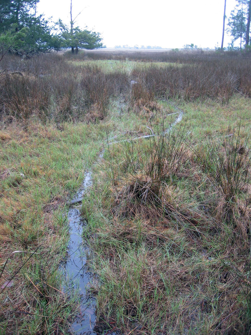
Trails made by feral cattle traveling far into a salt marsh on Sapelo Island, Georgia. But I thought cows only stayed in grassy fields and chewed their cuds? Please read on. (Photograph by Anthony Martin.)

As I mentioned in a previous entry, Sapelo is an excellent place to take university students for teaching basic coastal ecology, geology, ichnology, and taphonomy. Many ecologists consider it as the birthplace of modern ecology, which happened in the 1950s and ‘60s, and it hosted studies that established many basic principles of neoichnology (the study of modern traces) in the 1970s and ‘80s. For the latter, one of the key figures was Robert (Bob) Frey, who was my Ph.D. advisor when I attended the University of Georgia. Sapelo’s human history is also fascinating, dating back to more than 4,000 years ago – evidenced by a prominent Native-American shell ring – and continues through today with Hog Hammock, the only Gullah (“saltwater Geechee”) community left on the Georgia coast.

I have been to Sapelo dozens of times, with or without students, and each time there, I continue to be surprised and delighted by some new observation that reveals itself to those with open eyes and minds. Thus it has everything a field-oriented scientist could want, especially one who likes to learn something different with each visit.

All of these facts and feelings, though, may also lend to an impression that Sapelo is an idyllic and ecologically “pure” place, a true slice of what a Georgia barrier island should aspire to be. Alas, it is not, and like other Georgia barrier islands, Sapelo has been ecologically altered because of exotic plants and animals introduced there during colonial and post-colonial times. Among these species, the most noteworthy on Sapelo is Bos taurus, the only population of wild cattle on any Georgia barrier island and one of the few in the continental U.S.

Unlike the feral horses on Cumberland Island, nearly everyone agrees on the origin of the wild cattle on Sapelo: they are most likely descended from domestic cattle released on the island by millionaire R.J. Reynolds, Jr. (of carcinogenic fame). Although the details are sketchy as to exactly when and why he did this, Reynolds, who owned most of Sapelo from 1933 until his death in 1964, let loose his dairy cows and bulls in the first half of the 20th century. Many generations of these cattle have bred in the wild since, and still roam the island in sufficient numbers to warrant some attention from wildlife biologists, ecologists, and others interested in learning about their behavior and impacts on the local ecosystems.

In my experience, though, the words “wild” and “cattle” are rarely used in everyday conversations about these animals that, through our domestication of them, provide us with milk, cheese, and meat. Ask someone to describe a cow, for instance, and most people will be unflattering: “slow,” “docile,” and “stupid” are among the most common adjectives applied, which is sometimes followed by a giggling reference to the Midwestern U.S. tradition of cow-tipping.

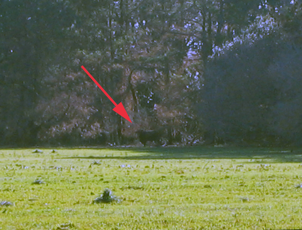
Thinking of tipping this cow? Be my guest, and be sure to forward the resulting video to Animal Planet for others’ lurid entertainment. The “cow” is actually a feral bull, and it was standing its ground at the edge of a field on Sapelo Island, fully aware that we spindly little bipeds were staring at it, and seemingly daring us to get closer. The poor quality of this photo is because I had my camera on maximum digital zoom: my momma didn’t raise no dumb kid. (Photograph by Anthony Martin.)

Yet these cattle are descended from wild species, aurochs (Bos primigenius) that survived the end-Pleistocene mass extinctions. You know, the same extinctions event that wiped out mammoths, mastodons, giant ground sloths, wooly rhinoceroses, saber-toothed cats, dire wolves, and other formidable megafauna of the Pleistocene. Hence aurochs must have had adaptive advantages over their Pleistocene cohorts. This was perhaps was related to their preferred ecosystems of wetland forests and swamps: remember that point with reference to Sapelo. Following the mass extinction, though, people in Eurasia, Africa, and India domesticated aurochs about 8,000 years ago. Through selective breeding, people came up with the present-day varieties we see of Bos taurus, which is considered a subspecies of B. primigenius.

Painting titled The Aurochs, by Heinrich Harder (1858-1935), probably made in 1920. Image is in the public domain and I found it on this Web site, authored by Peter Maas. Contrast how the artist depicted an auroch fighting off a pack of wolves with current expectations of how domestic cattle should behave in the face of pack-hunting predators, and you’ll get a better sense of the actual behaviors shown by wild cattle on Sapelo Island.

I am reminded of this evolutionary heritage whenever I go to Sapelo, because the cattle there are cryptic creatures of the maritime forest. Yes, that’s right: cryptic and living in the forest. A casual day-trip visitor to Sapelo will almost never see one, let alone any of several small herds that roam the island. Whenever an individual bull or herd is encountered in more open, grassy areas, they seemingly revert to Pleistocene behavior and slip into the woods, quickly concealing themselves from the prying eyes of humans. In short, they are not slow, docile, or stupid, and would never allow a person to get close enough to make an short-lived and ill-fated attempt to tip any of them.

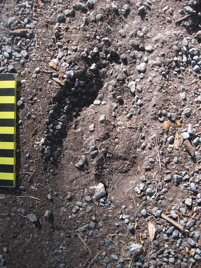
This is about all you’ll see of a recent presence of the feral cattle on Sapelo Island: tracks, and if you are lucky enough to sight one, it will leave a lot more tracks and sign for you to study than that all-too-brief glimpse. Scale is in centimeters, and look closely where the slightly smaller the rear-foot track (manus) registered directly on top of the fron-tfoot (pes) track. (Photograph by Anthony Martin.)

Hence any meaningful study of these cattle and their ecological effects on Sapelo requires the use of – you guessed it – ichnology. Consequently, I have tracked these cattle, sometimes with my students and sometimes by myself, during many visits there. Although these tracking forays have generated many anecdotal yarns of yore about these “wild cows of mystery” worth retelling, I will reluctantly restrict myself here to summarizing their traces and the effects of these traces on the landscapes of Sapelo.

Traces of feral cattle on Sapelo consist largely of their tracks, trails or otherwise trampled areas, feces, and chew marks. In my experience, the vast majority of their traces are on the northern half of the island, although herds or individual bulls will occasionally leave their marks in the southern half when they graze on grassy areas there.

Tracks made by these feral cattle are unmistakable when compared to those of any other hoofed animal on Sapelo – such as white-tailed deer or feral hogs – which is a function of their greater size. Tracks are shaped like robust, upside-down Valentine’s hearts, with two bilaterally symmetrical hoof impressions rounded in the front and back. Tracks are normally about 9-14 cm (3.5-5.5 in) long, although I have seen newborn calf tracks as small as 5-6 cm (2-2.3 in) long; track widths are slightly less (by about 20%) than lengths. These cattle, like deer, spend much of their time walking slowly, so their rear-foot (pes) impressions often overlap behind their front-foot (manus) impressions, but can also overprint in direct register. Trackways typically show a diagonal-walking pattern, although these can be punctuated by frequent “T-stops,” in which tracks form a “T” pattern, with the top of the “T” made by the front feet whenever a trackmaker stopped.

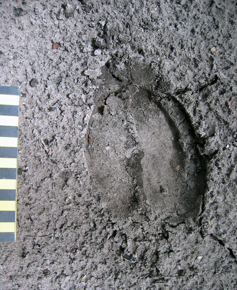
Near-perfect direct register of smaller rear foot into front-foot tracks made by adult feral cow, recorded in exquisite detail in fine-grained sand. Scale in centimeters. (Photograph by Anthony Martin, taken on Sapelo Island.)

Because these cattle, for the most part, obey herding instincts, they habitually follow one another along the same narrow pathways through maritime forests and salt marshes, resulting in well-worn trails that wind between live oaks in forest interiors or cut straight across marshes. Nonetheless, the cattle also like to use the open freeways provided by the sandy roads that criss-cross much of the northern part of the island, which makes tracking them much easier, especially after a hard rain has “cleaned the slate.” When using a road, the cattle break single file and walk parallel or just behind one another, indicated by their overlapping and side-by-side trackways. On forest trails, they often drag their hooves across the tops of logs downed along trails, chipping and otherwise breaking down the wood.

Feral cattle tracks showing different sizes – and hence age structures – of the cattle, with some trackways overlapping (following one another) and some parallel, taking up the entire width of a sandy road on the north end of Sapelo Island. (Photographs by Anthony Martin, composite of three stitched together in Photoshop™.)

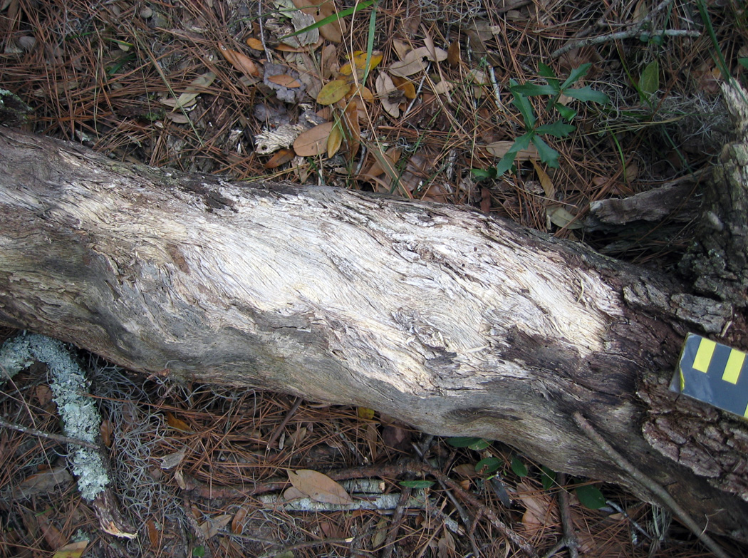
Log on feral-cattle trail, showing chipped wood on surface where hooves dragged across the top, possibly over generations of trail use. White-tailed deer do a similar behavior on their trails, but do not cause such obvious traces. (Photograph by Anthony Martin, taken on Sapelo Island.)

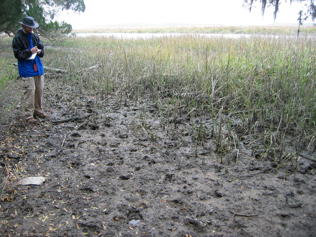
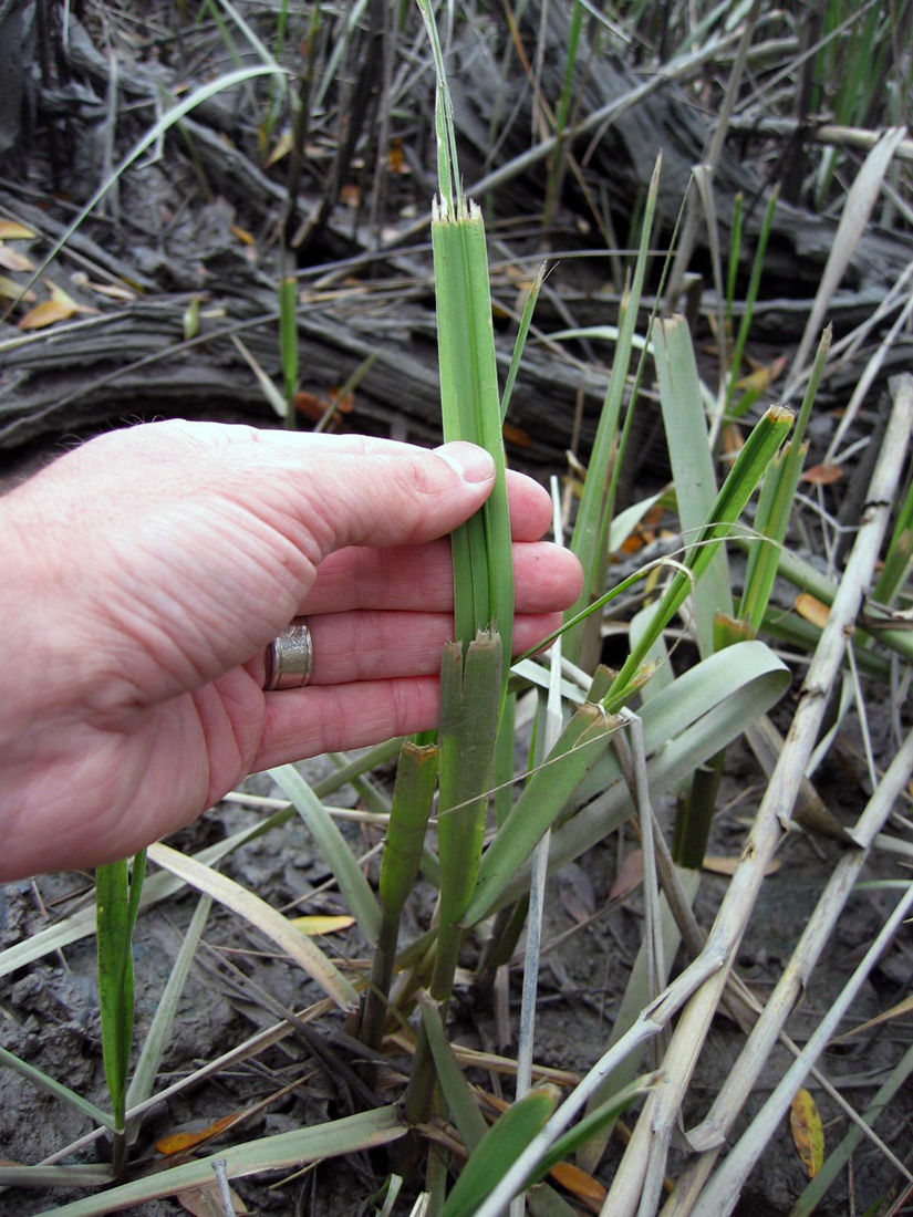
OK, here’s a reminder of something I just said and showed in a photo earlier: these cattle also form trails that wind deeply into the salt marshes. Why? Turns out that instead of restricting themselves to a terrestrial-only diet, they are eating smooth cordgrass (Spartina alterniflora), which grows abundantly in the marshes. This feeding results in their leaving many other traces, such as near-ground-level cropping of Spartina with clean tears, accompanied by considerable trampling of grazed areas. Although I was surprised to discover this for myself several years ago, people who raised cattle on the island in the 19th and early 20th centuries, perhaps through necessity, knew about this alternative foodstuff and fed it to cattle as a substitute for hay. Sure enough, historical references verify the use of smooth cordgrass as part of their diet (of the cattle, not the people, that is).

Evidence that feral cattle of Sapelo walk into salt marshes as a herd and eat the smooth cordgrass (Spartina alterniflora) there, based on trampling and overgrazing. Michael Bauman, who was an Emory undergraduate student at the time, for scale. (Photographs by Anthony Martin.)

Close-up of traces left on smooth cordgrass from feral cattle grazing, which are at various heights according to the level of their grazing activity. (Photograph by Anthony Martin, taken on Sapelo Island.)

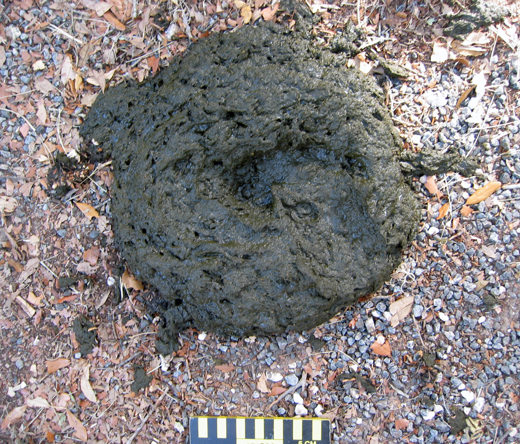
Of course, among the most obvious traces these cattle leave in their wake are the end products of digestion (pun intended), feces. These “cow patties” vary in size depending on both the size of the tracemaker and liquid content of the scat. The bigger the tracemaker and the greater the water content to the plants, the wider the patties, which can exceed dinner-plate size. Similar to the situation on Cumberland Island with its feral horses and their feces, the native dung beetles must not be able to keep up with such a bounty, as I see many unrecycled, dried patties throughout the island, and have nearly stepped on freshly dropped pies that showed no signs of having been discovered by caring dung-beetle mothers.

Looks like cow scat. Smells like cow scat. Feels like cow scat. Tastes like cow scat. Good thing we didn’t step in it! But notice that the tracemaker did, leaving a bonus trace (track) on top of its impressive pile. (Photograph taken by Anthony Martin, taken on Sapelo Island.)

Given that the northern part of the island has extensive salt marshes flanking the maritime forest, and places with fresh-water sloughs containing more wetland plants, it makes sense that the cattle would stay mostly in that half of the island. The absence of humans on the north end of the island – other than occasional deer hunters, Department of Natural Resources personnel, or crazy ichnologists – is also a plus, as these cattle avoid people whenever possible.

But how does any of this relate to geology and paleontology? Well, because these feral cattle interact so much with Sapelo salt marshes, I actually included these animals as marginal-marine tracemakers in my upcoming book (Life Traces of the Georgia Coast, just in case you needed reminding). This places these bovines in the same category as feral horses – which negatively affect coastal dunes and salt marshes – and feral hogs, which even go into the intertidal zones of beaches for their foraging.

The biggest difference between the cattle and these other two hoofed species, though, is their impact on the marshes. In all of my years of noting cattle tracks and other sign on Sapelo, I have never seen evidence of their going to the beach, or even to the coastal dunes. Instead, they stay in the forests and wetlands, whether the latter are fresh-water or salt-water ones. This possibly reflects how the cattle, within just a few generations, switched back to auroch behaviors of the Pleistocene, preferring to live in wooded wetlands instead of in the terrestrial grasslands we modern humans keep forcing them to graze.

Thus any paleontologists looking into the fossil record of aurochs or their ancestral species – whether of body fossils or trace fossils – might use these present-day clues when prospecting for fossils. This serves as a great example of why I urge paleontologists to pay attention to invasion ecology and conservation biology, in which “ecologically impure” invasive species give us valuable insights on their evolutionary histories.

What else can we learn about these feral cattle and their ecological and geological impacts on Sapelo, especially through studies of their traces? For one, knowing the actual number of cattle on the island would be useful, as their quantity surely relates to how well the island ecosystems can handle present and future populations. But probably more important than this would be better defining their behaviors in the context of these non-native ecosystems. How to do this with a species that stays hidden so well, one that has apparently reverted to a Pleistocene way of life? Fortunately, behaviors can be defined through the ichnological methods I have outlined here. These methods can then easily augment others normally used by conservation biologists, such as trail cameras and direct observation.

Once this is done, we will know much more about these wild cattle than before, and will no longer have to rely on whispered legends of the mysterious bovines of Sapelo Island. Regardless, there is certainly still room for such stories, perhaps even artwork, operas, plays, movies, and music. Cattle have played such an integral role in the development of humanity, there is every reason to suppose that, as long as they continue to live on Sapelo, they and their traces will continue to intrigue us.

Further Reading

Ajmone-Marsan, P., Fernando Garcia, J., and Lenstra, J.A. 2010. On the origin of cattle: how aurochs became cattle and colonized the world. Evolutionary Anthropology, 19: 148-157.

Bailey, C., and Bledsoe, C. 2000. God, Dr. Buzzard, and the Bolito Man: A Saltwater Geechee Talks about Life. Doubleday, New York: 334 p.

McFeeley, W.S. 1995. Sapelo’s People: A Long Walk into Freedom. W.W. Norton, New York: 200 p.

Sullivan, B. 2000. Sapelo Island (GA): Images of America. Arcadia Publishing,  Mt. Pleasant, South Carolina: 128 p.

Teal, M., and Teal, J.M. 1964. Portrait of an Island. Atheneum, New York: 167 p. [reprinted by University of Georgia Press, Athens, in 1997: 184 p.]

Tracking the Wild Horses of Cumberland Island

(The following post is one of a series about traces of important invasive species of mammals on the Georgia barrier islands and the ecological effects of these traces. An introduction to this topic from last week is here.)

Perhaps the most charismatic yet problematic of non-native animals on any of the Georgia barrier islands are the wild horses (Equus caballus) of Cumberland Island. These horses are the source of much controversy, which becomes even more apparent whenever anyone tries to apply some actual science to them. So I will talk about them here from my perspective as a paleontologist and geologist in the hope that this will add another dimension to what is often presented as a two-sided and emotional argument.

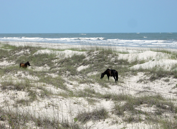
Ah, the wild horses of Cumberland Island, Georgia, roaming free since the time of the Spanish in a pristine, unspoiled landscape, grazing contently on the sea oats and strolling through the coastal dunes, in perfect harmony with nature. How much of the preceding sentence is wrong? Almost all of it. If you want to find out why, please read on. But if your mind is already made up about the feral horses of Cumberland and you don’t want to hear anything bad said about them, then you might like this site. (Photograph by Anthony Martin.)

Cumberland Island, much of which is part of the U.S. National Park system as a National Seashore, is the only Georgia barrier island with a population of feral horses. Nevertheless, despite their uniqueness and fame – the latter figuring as key attractions in advertisements about Cumberland and inspiring dreamy book titles – their origins remain murky. One of the recurring romanticized claims is that these horses descended from livestock brought there by Spanish expeditions in the 16th century. This idea is reassuring to the people who repeat it for two reasons:

(1) It establishes horses as living in the landscape for a long time (especially by American standards), meaning that their presence there now is considered “natural.”

(2) It lends itself to the comforting thought that the horses connect to a European cultural heritage, putting an Old World imprint on a New World place.

However, once said enough times, such just-so stories become faith-based and any evidence contradicting them is not tolerated. Thus even when genetic studies of the Cumberland horses show they are not appreciably different from populations of horses on other islands of the eastern U.S. (arguing against a purely Spanish origin), any questioning of the stated premise – in my experience – provokes angry responses from its defenders.

I suspect this virulent reaction is a direct result of challenging both the “naturalness” and “cultural heritage” of the horses on Cumberland. In reality, though, these are opposing values. After all, an admission that these feral horses came from European stock at any point during the past 500 years supports how they clearly do not belong on Cumberland Island, or anywhere else in the Western Hemisphere if we’re talking about the last 10,000 years or so. In other words, the point is moot whether the current horse population originated in the 16th, 17th, 18th, 19th, or 20th century, or is a mixture of older and newer stock. If only horses could talk, then we would know for sure. (A detailed history of the horses on Cumberland Island is provided here for anyone interested in learning more about this.)

Arguments of heritage aside, these horses are newcomers in a geological and ecological sense. The fossil record of the modern Georgia barrier islands backs this up, as some of the islands (including Cumberland) have sediments more than 40,000 years old, but none have body or trace fossils of horses, or anything like a horse. Although three species of horses were living on the mainland part of North America during the Pleistocene Epoch until their respective extinctions more than 10,000 years ago, none were known to have inhabited any of the barrier islands, Pleistocene or recent. The closest ancient analogue to horses on any of the Georgia barrier islands would have been bison (Bison bison), but their bones are rare. This scarcity leads paleontologists to wonder whether the islands ever had self-sustaining populations of large herbivores.

So with all of that human history and pre-history in mind, the traces made by the feral horses of Cumberland and their ecological effects are exceptional to it and every other Georgia barrier island, and hence worth our attention. Just to keep this simple, I will cover three primary types of traces made by these horses. What these traces all have in common (other than being made by a horse, of course) is the decidedly negative impacts these have on the native plants and animals of Cumberland, including keystone species in the oft-labeled “pristine” ecosystems of the island.

Tracks and trails – These traces are the abundant and easily spotted on Cumberland, even to someone with little or no training in ichnology. Horses are unguligrade, which means they are walking on their toenails (unguals), and the ungual (more popularly called a hoof) is on a single digit. Hooves make circular to slightly oval compression shapes, but if preserved in the right substrate – like a firm mud or fine sand – they will show a “Pac-Man”-like form. Front-foot (manus) tracks are slightly larger than rear-foot (pes) tracks; manus impressions are 11-14 cm (4.3-5.5 in) long and 10-13 cm (4-5.1 in) wide, whereas pes impressions are 11-13 cm (4.3-5.1 in) long and 9-12 cm (3.5-4.7 in) wide, with variations in size depending on ages of the horses making the tracks.

Trackway of feral horse moving through the coastal dunes of Cumberland Island. Note the diagonal walking pattern and how front- and rear-foot impressions merge to make oblong compound traces.

An important point to keep in mind when tracking horses or any other hoofed animals is that their feet readily cut through sediments and vegetation, leaving much more sharply defined and deeper impressions than padded feet of an equivalent-sized animal. Because Georgia-coast sands contain whitish quartz and darker heavy minerals, these contrasting sand colors help to outline horse tracks on surfaces and in cross-section as deep and sharply defined structures that cut across the bedding.

When asked to think about horses in motion, it might be tempting to imagine them galloping, especially along a beach at sunset. Nonetheless, a horse would tire quickly if it galloped all day, especially for no valid reason. Instead, its normal gait is a slow walk, which causes the rear foot to register partially on top of the front-foot impression, but slightly behind; with a slightly faster walk, the rear foot will exceed the front-foot impression. The overall trackway pattern then is what many trackers call “diagonal-walking,” as the right-left-right alternation of steps can be linked with imaginary diagonal lines. Trackway width, also known as straddle, is about 20-40 cm (8-16 in) if a horse was just walking normally, but narrows noticeably once it starts picking up speed.

Feral-horse tracks on Cumberland Island, a close-up of the same trackway shown in the previous photo. This one was likely doing a slow walk, with indirect register of the rear foot just behind and onto the front-foot impression. The scale (my shoe) is a size 8½ mens. (Photograph by Anthony Martin.)

Given enough back-and-forth movement along preferred paths, repeating and overlapping trackways result in trails, which can be picked out as linear bare patches of exposed sand or mud cutting through vegetation. Because horses are much larger than the native white-tailed deer (Odocoileus virginianus) on Cumberland, their trails are considerably wider.

Feral-horse trail along the edge of a low salt marsh where they have trampled and overgrazed the smooth cordgrass in that marsh (Spartina alterniflora). (Photograph by Anthony Martin, taken on Cumberland Island.)

Chew marks – Horses are grazers and low-level browsers, and they eat a wide variety of vegetation on Cumberland. The most important plant species they eat through grazing are smooth cordgrass (Spartina alterniflora), sea oats (Uniola paniculata), and live oak (Quercus virginiana).  All three of these plants are keystone species in their respective ecosystems: smooth cordgrass predominates in the low salt marshes, sea oats are the mainstay plants of coastal dunes, and live oaks are the largest and most long-lived trees in the maritime forests. Their effects of horses consuming  smooth cordgrass and sea oats is straightforward, as these plants hold in sediments in place keep them from eroding, but how do horses affect live oaks? They eat the seedlings, which means that older oaks are being replaced by younger ones at a slower rate.

Grazing traces consist of clean cuts of vegetation within a vertical swath and over a broad area. Horses, unlike white-tailed deer, have teeth on both their upper and lower jaws, thus they shear plants on the branches, stems, or leaves. In contrast, deer leave more ragged marks, as they only have teeth on their lower jaws and hence have to pull on vegetation to break it off. Horses also can make a browse line, which is an abrupt horizontal line of decreased vegetation at a certain consistent height that more-or-less correlates with the average head height of the horses.

Dung – During any given stroll on Cumberland, you cannot avoid seeing, smelling, and stepping in horse feces. This abundance of fecal material means that the feces are not being recycled quickly enough into the ecosystems, which implies that native populations of dung beetles are overwhelmed by such abundance. I have seen a few traces of dung beetles in fresh piles of feces, but no matter how hard I have looked, I have yet to witness great thundering herds of beetles rolling balls of dung across the Cumberland Island landscape.

An impressive collection of horse dung, which was probably dropped by a single horse. Note the small holes in the middle, which were likely made by dung beetles that tunneled into this rich supply of food for their offspring.

Close-up of those probable dung-beetle burrows, some with short trails attached. The white quartz sand sprinkled on top shows how it was pulled up by beetles from underneath the dung pile and onto the top surface, thus giving a minimum depth of the burrows. (Both photographs by Anthony Martin, taken on Cumberland Island.)

One of the more interesting ecological consequences of horse dung I have seen on Cumberland is how it influences the behavior of smaller animals as pellets or piles form a microtopography. For example, on some of the dunes near Lake Whitney on Cumberland – the largest body of fresh water on any of the Georgia barrier islands – I was surprised to see that small lizards – probably skinks – were moving around the dung piles or burrowing under them.

Horse droppings as a part of the landscape for small lizards. Here their tracks, accompanied by tail dragmarks, wind around partially buried feces in a sand dune. (Photograph by Anthony Martin, taken on Cumberland Island.)

Small lizard burrow entrance immediately below a horse pellet, showing its use as a sort of roof. This could probably inspire some clever statement on shingles and, well, you know, but I’ll refrain for now. (Photograph by Anthony Martin, taken on Cumberland Island.)

All three categories of traces – tracks, chew marks, and dung – can be found together in ecosystems wherever horses are trampling, grazing, and defecating, respectively.

So now let’s put on our paleontologist or geologist hats (not to be confused with archaeologist hats) and ask ourselves about the likelihood of such traces making it into the fossil record, and how we would recognize them if they did. Their likelihood of preservation, in order, would be tracks, feces, and chew marks. Tracks would be evident as large compression shapes in horizontal bedding planes or deep disruptions of bedding planes in vertical section. Feces, or their fossil versions called coprolites, might get preserved, although herbivore feces, filled with vegetative material, is less likely to make it into the fossil record compared to carnivore feces, which may have lots of bone material in it. The last of these – chew marks – would be nearly impossible to tell from normal tearing and other degradation of plant material before it became fossilized. Good luck on that.

But could the ecological damage caused by an invasive species, in which the introduction of a species serve as a sort of trace fossil in itself? In the case of horses or ecologically similar animals, subtle changes to the landscape over time might take place. This experiment actually has been done on Assateauge Island (North Carolina), which also has a feral horse population. In areas where horses were excluded by fences, the dunes were on average 0.6 meters (2 ft) feet higher than those of overgrazed and trampled dunes. Geologists conducted another study done on Shackleford Banks (North Carolina) in which they examined areas where fences had separated non-horse from horse-occupied parts of the island. These geologists similarly found that horses caused dunes to be less than 1.5 m (5 ft) high, whereas dunes without horses were as much as 3.5 m (11.5 ft) high. This meant that storms more easily penetrated the barriers provided by coastal dunes, more commonly resulting in storm-washover fans.

This change in the coastal geology of back-dune areas also means that ground-nesting shorebirds will become less common, as their nests and nestlings will be drowned or buried more frequently. Horses also are known to step on shorebird eggs and nests, or can scare away parents from nests, which increases the likelihood of egg or nest predators taking out the next generation of shorebirds.

If any horses made it to the Georgia barrier islands during the Pleistocene and established breeding populations, a geologic sequence following their arrival would look like this, from bottom to top: high dunes suffused with root traces (before horses); lower dunes corresponding with fewer root traces and deep disruptions of bedding (horse tracks); increased numbers of storm-washover fans; and a high salt-marsh. In short, a geologist would see an overall progression from a dune-dominated shoreline to a high salt marsh. Similarly, a paleontologist might see a decrease in root trace fossils and shorebird nests, eggshells, and tracks, possibly culminating in local extinctions of each.

This is your Georgia coast.

This is your Georgia coast with horses. Any questions?

Top panorama is of high-amplitude coastal dunes and well-vegetated back-dune meadows on Sapelo Island, whereas the bottom panorama is of low-amplitude dunes with no appreciable back-dune meadows on Cumberland Island. (Both panoramas based on photos taken by Anthony Martin.)

Based on what we know then, should the feral horses of Cumberland Island be removed? Yes. Will they be removed? Probably not. However, regardless of happens, I will keep teaching about the horses of Cumberland Island and their traces, both as an educator and a concerned citizen. Perhaps with enough awareness, circumstances will change for the better so that Cumberland Island can not only remain a beautiful place, but also will become more like what it was before the arrival of horses there.

(Next week in this series about invasive mammal species of the Georgia barrier islands and their traces, I’ll cover a less inflammatory but still intriguing topic: the feral cattle of Sapleo Island.)

Further Reading

Buynevich, I.V., Darrow, J.S., Grimes, T.A.Z., Seminack, C.T., and Griffis, N. 2011. Ungulate tracks in coastal sands: recognition and sedimentological significance. Journal of Coastal Research, Special Issue 64: 334-338.

De Stoppalaire, G.H., Gillespie, T.W., Brock, J.C., and Tobin, G.A. 2004. Use of remote sensing techniques to determine the effects of grazing on vegetation cover and dune elevation at Assateague Island National Seashore: impact of horses. Environmental Management, 34: 642-649.

Dilsaver, L.M. 2004. Cumberland Island National Seashore: A History of Conservation Conflict. University of Virginia Press, Charlottesville, Virginia: 304 p.

Elbroch, M. 2003. Mammal Tracks and Sign: A Guide to North American Species. Stackpole Books, Mechanicsburg, Pennsylvania: 779 p.

Goodloe, R.B., Warren, R.J., Osborn, D.A., and Hall, C. 2000. Population characteristics of feral horses on Cumberland Island and their management implications. The Journal of Wildlife Management, 64: 114-121.

Sabine, J.B., Schweitzer, S.H., and Meyers, J.M. 2006. Nest Fate and Productivity of American Oystercatchers, Cumberland Island National Seashore, Georgia. Waterbirds, 29: 308-314.

Turner, M.G. 1987. Effects of grazing by feral horses, clipping, trampling, and burning on a Georgia salt marsh. Estuaries and Coasts, 10: 54-60.

Turner, M.G. 1988. Simulation and management implications of feral horse grazing on Cumberland Island, Georgia. Journal of Range Management, 41: 441-447.


Shorebirds Helping Shorebirds, One Whelk at a Time

How might the traces of animal behavior influence and lead to changes in the behavior of other animals, or even help other animals? The sands and the muds of the Georgia barrier islands answer this, offering lessons in how seemingly inert tracks, trails, burrows, and other traces can sway decisions, impinging on individual lives and entire ecosystems, and encourage seemingly unlikely partnerships in those ecosystems. Along those lines, we will learn about how the traces made by laughing gulls (Larus altricilla) and knobbed whelks (Busycon carica) aided sanderlings (Calidris alba) in their search for food in the sandy beaches of Jekyll Island.

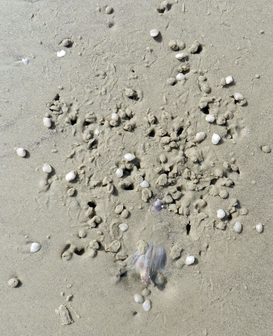
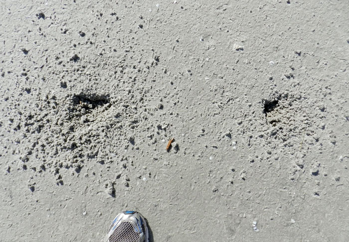
A roughly triangular depression in a beach sand on Jekyll Island, Georgia, blurred by hundreds of tracks and beak-probe marks of many small shorebirds, all of which were sanderlings (Calidris alba). What is the depression, how was it made, and how did it attract the attention of the sanderlings? Scale = size 8 ½ (men’s), which is about 15 cm (6 in) wide. (Photograph by Anthony Martin.)

Last week, we learned how knobbed whelks (Busycon carica), merely through their making trails and burrows in the sandy beaches of Jekyll Island, unwittingly led to the deaths of dwarf surf clams (Mulinia lateralis), the latter eaten by voracious sanderlings. Just to summarize, the dwarf surf clams preferentially burrowed around areas where whelks had disturbed the beach sand because the burrowing was easier. Yet instead of avoiding sanderling predation, the clustering of these clams around the whelks made it easier for these shorebirds to eat more of them in one sitting. Even better, this scenario, which was pieced together through tracks, burrows, and trails, was later verified by: catching whelks in the act of burying themselves; seeing clams burrow into the wakes of whelk trails; and watching sanderlings stop to mine these whelk-created motherlodes of molluscan goodness.

Before and after photos, showing how the burrowing of a knobbed whelk caused dwarf surf clams to burrow in the same small area (top), which in turn provided a feast for sanderlings (bottom); the latter is evident from the numerous tracks, peak-probe marks, and clam-shaped holes marking where these hapless bivalves formerly resided. (Both photographs by Anthony Martin, taken on Jekyll Island, Georgia.)

Was this the only trace-enhanced form of predation taking place on that beach? By no means, and it wasn’t even the only one involving whelks and their traces, as well as sanderlings getting a good meal from someone else’s traces. This is where a new character – the laughing gull (Larus altricilla) – and a cast of thousands represented by the small crustaceans – mostly amphipods – enter the picture. How these all come together through the life habits and traces these animals leave behind is yet another example of how the Georgia coast offers lessons in how the products of behavior are just as important as the behavior itself.

Considering that knobbed whelks are among the largest marine gastropods in the eastern U.S., it only makes sense that some larger animal would want to eat one whenever it washes up onto a beach. For example, seagulls, which don’t need much encouragement to eat anything, have knobbed whelks on their lengthy menus.

So when a gull flying over a beach sees a whelk doing a poor job of playing “hide-and-seek” during low tide, it will land, walk up to the whelk, and pull it out of its resting spot. From there, the gull will either consume the whelk on the spot, fly away with it to eat elsewhere (“take-out”), or reject it, leaving it high and dry next to its resting trace. An additional trace caused by gull predation might be formed when gulls carry the whelk through the air, drop them onto hard surfaces – such as a firmly packed beach sand – which effectively cracks open their shells and reveals their yummy interiors.

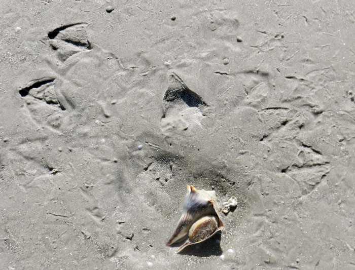
Paired gull tracks in front of a knobbed whelk resting trace, with the whelk tracemaker at the bottom of the photo. Based on size and form, these tracks were made by laughing gulls (Larus altricilla). The one on the left is likely the one that plucked the whelk from its resting trace, as its feet were perfectly positioned to pick up the narrow end of the whelk with its beak. The second gull might have seen what the first was doing and arrived on the scene soon afterwards, hoping to steal this potential meal for itself. For some reason, though, neither one ate it; instead, they discarded their object of desire there on the sandflat. For those of you who wondered if I then just walked away after taking the photo, I assure you that I threw the whelk back into water. At the same time, though, I acknowledged that the same sort of predation and rejection might happen again to that whelk with the next tidal cycle. Other shorebird tracks in the photo are from willets and sanderlings. (Photograph by Anthony Martin, taken on Jekyll Island.)

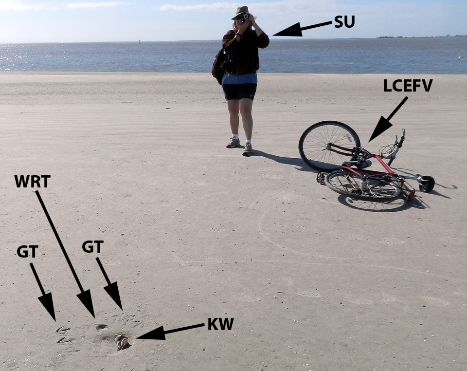
Sure enough, on the same Jekyll Island beach where we saw the whelk-surf clam-sanderling interactions mentioned last week, and on the same day, my wife Ruth Schowalter and I noticed impressions where whelks had incompletely buried themselves at low tide, only to be pried out by laughing gulls. Although we did not actually witness gulls doing performing, we knew it had happened because their paired tracks were in front of triangular depressions, followed by more tracks with an occasional discarded (but still live) whelk bearing the same dimensions as the impression.

My wife Ruth aptly demonstrates how to document seagull and whelk traces (foreground) while on bicycle, no easy feat for anyone, but a cinch for her.  Labels are: GT = gull tracks; WRT = whelk resting trace; KW = knobbed whelk; SU = spousal unit; and LCEFV = low-carbon-emission field vehicle. (Photograph by Anthony Martin, taken on Jekyll Island, Georgia.)

With this search image of a whelk resting trace in mind, we then figured out what had happened in a few places when we saw much more vaguely defined triangular impressions. These were also whelk resting traces, but they were nearly obliterated by sanderling tracks and beak marks; there was no sign of gulls having been there, nor any whelk bodies. Hence these must have been instances of where the gulls flew away with their successfully acquired whelks to drop them and eat them somewhere else. But why did the sanderlings follow the gulls with the shorebird equivalent of having a big party in a small place?

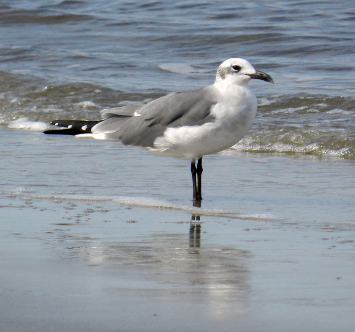
Yeah, I did it: so what? A laughing gull, looking utterly guiltless, stands casually on a Jekyll Island beach, unaware of how its going after knobbed whelks also might be helping its little sanderling cousins find amphipods. (Photograph by Anthony Martin.)

Although many people may not know this, when they walk hand-in-hand along a sandy Georgia beach, a shorebird smorgasbord lies under their feet in the form of small bivalves and crustaceans. The latter are mostly amphipods (“sand fleas”), which through sheer number of individuals can compose nearly 95% of the animals living in Georgia beach sands. Amphipods normally spend their time burrowing through beach sands and eating algae between sand grains or on their surfaces.

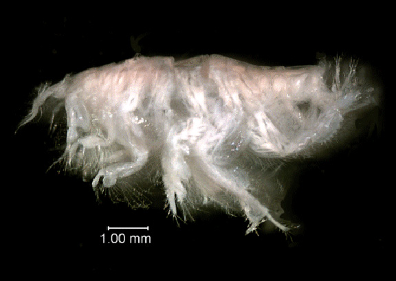
Close-up view of the amphipod Acanthohaustorius millsi, one of about six species of amphipods and billions of individuals living in the beach sands of the Georgia barrier islands, all of which are practically begging small shorebirds to eat them. Photo from here, borrowed from NOAA (National Oceanic and Atmospheric Administration – a very good use of U.S. taxpayer money, thank you very much) and linked to a site about Gray’s Reef National Marine Sanctuary, which is about 30 km (18 mi) east of Sapelo Island, Georgia.

Because amphipods are exceedingly abundant and just below the beach surface, they represent a rich source of protein for small shorebirds. But if you really want to make it easier for these shorebirds to get at this food, just kick your feet as you walk down the beach. This will expose these crustaceans to see the light of day, and the shorebirds will snap them up as these little arthropods desperately try to burrow back into the sand. This, I think, is also what happened with the gulls pulling whelks off the beach surface. Through the seemingly simple, one-on-one predator-prey act of a gull picking up a whelk, it exposed enough amphipods to attract sanderlings, which then set off a predator-prey interaction between the sanderlings and amphipods, all centered on the resting trace of the whelk.

Two whelks near one another resulted in two resting traces, and now both are missing, which likely means they were taken by laughing gulls. Notice how all of the sanderling trampling and beak marks have erased any evidence of the gulls having been there. (Photograph by Anthony Martin, taken on Jekyll Island.)

So as a paleontologist, I always ask myself, how would this look if I found something similar in the fossil record, and how would I interpret it? What I might see would be a dense accumulation of small, overlapping three-toed tracks – with only a few clearly defined – and an otherwise irregular surface riddled by shallow holes. The triangular depression marking the former position by a large snail, obscured by hundreds of tracks and beak marks, might stay unnoticed, or if seen, could be disregarded as an errant scour mark. The large gull tracks would be gone, overprinted by the many tracks and beak marks of the smaller birds.

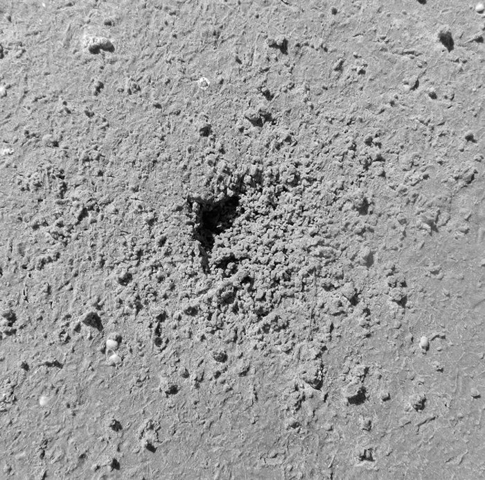
Take a look again at the scene shown in the first photograph, and imagine it fossilized. Could you piece together the entire story of what happened, even with what you now know from the modern examples? I’m sure that I couldn’t. Scale bar = 15 cm (6 in). (Photograph by Anthony Martin.)

Hence the role of the instigator for this chain of events, the gull or its paleontological doppelganger, as well as its large prey item, would remain both unknown and unknowable. It’s a humbling thought, and exemplary of how geologist or paleontologist should stop to wonder how much they are missing when they recreate ancient worlds from what evidence is there.

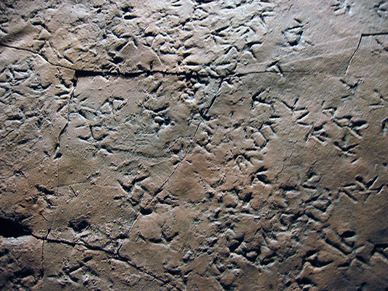
Cast (reproduction) of a dense accumulation of small shorebird-like tracks from Late Triassic-Early Jurassic rocks (about 210 million years old) of Patagonia, Argentina. These tracks are probably not from birds, but from small bird-like dinosaurs, and they were formed along a lake shoreline, rather than a seashore. Nonetheless, the tracemaker behaviors may have been similar to those of modern shorebirds. Why were these animals there, and what were they eating? Can we ever know for sure about what other animals preceded them on this small patch of land, what these predecessors eating, and how their traces might have influenced the behavior of the trackmakers? (Photograph by Anthony Martin; cast on display at Museo de Paleontológica, Trelew, Argentina.)

Another parting lesson that came out of these bits of ichnological musings is that all of the observations and ideas in this week’s and last week’s posts blossomed from one morning’s bicycle ride on a Georgia-coast beach. Even more noteworthy, these interpretations of natural history were made on an island that some scientists might write off as “too developed” to study, its biota and their ecological relationships somehow sullied or tainted by a constantly abundant and nearby human presence. So whenever you are on a Georgia barrier island, just take a look at the life traces around you, whether you are the only person on that island or one of thousands, and prepare to be awed.

Further Reading

Croker, R.A. 1968. Distribution and abundance of some intertidal sand beach amphipods accompanying the passage of two hurricanes. Chesapeake Science, 9: 157-162.

Elbroch, M., and Marks, E. 2001. Bird Tracks and Sign of North America. Stackpole Books. Mechanicsburg, Pennsylvania: 456 p.

Grant, J. 1981. A bioenergetic model of shorebird predation on infaunal amphipods. Oikos, 37: 53-62.

Melchor, R. N., S. de Valais, and J. F. Genise. 2002. The oldest bird-like fossil footprints. Nature, 417:936938.

Wilson, J. 2011. Common Birds of Coastal Georgia. University of Georgia Press, Athens, Georgia: 219 p.

“Worm Burrows” as a Geological Cliché

This past week, I was privileged to have participated in a marvelous three-day field trip to the Triassic and Jurassic sedimentary rocks in and around St. George, Utah. The field trip, organized by paleontologist Andrew Milner and many others in association with the Society of Vertebrate Paleontology meeting in Las Vegas, Nevada, provided our enthusiastic group of nearly forty professional and amateur paleontologists with a grand geological tour of southern Utah and northern Arizona, along with the fantastic dinosaur tracksites in that area.

Foremost among these places where dinosaurs left their marks was one of the most incredible tracksites have seen anywhere, which, like Lark Quarry in Queensland, Australia, is enclosed within a building to protect it. This place, called the St. George Dinosaur Discovery Site at Johnson Farm, has one of the few sitting-dinosaur trace fossils known from the fossil record, along with the world’s best collection of dinosaur swimming tracks, rare examples of dinosaur tail-drag marks, hundreds of other dinosaur tracks, and thousands of invertebrate trace fossils. All were enthralling as detailed records of daily life in the Early Jurassic Period, from about 195 million years ago.

You would think on a field trip like this that Georgia – countering Ray Charles’ memorialized sentiment – would not be on my mind. Yet the modern traces made by living animals of the Georgia barrier islands habitually creep into my thoughts whenever I travel into the geological past. In this instance, the trigger for my thoughts of Georgia traces was through hearing other field-trip participants utter the most recurring of geological clichés connected to invertebrate trace fossils: “worm burrows.”

Invertebrate trace fossils (left) directly associated with theropod dinosaur footprints (right) from the Moenave Formation (Lower Jurassic), southern Utah. These trace fossils are probably the burrows of larval insects made in moist muddy sand, rather than burrows made by earthworms in soils. So don’t be calling them “worm burrows,” or else a baby kitten will get mildly scolded. (Photograph by Anthony Martin.)

Several people spontaneously spoke this ichnological banality as soon as they saw small burrows preserved in the rock, many of which were directly associated with the exquisitely preserved dinosaur tracks. This happened often enough (which is to say, twice) that I just had to call attention to this geological faux pas. “Stop saying ‘worm burrows’!” I said with mock outrage. I quickly followed my joking admonishment with a brief explanation of how most of the burrows were much more likely to be from insects, rather than worms. Traits of the burrows – such as scratchmarks and short, branching, angled tunnels – implied insect tracemakers, such as the larvae of beetles or flies.

Insect traces associated with dinosaur tracks should not be all that surprising to anyone. After all, insects originated in terrestrial environments about 400 million years ago, meaning they were more than halfway through their evolutionary history by the time these Jurassic trace fossils were made. I had seen many similar burrows made by insects on the Georgia barrier islands and elsewhere in Georgia, which gave me enough confidence to propose their more probable identity.

Insect burrows – probably made by “mud-loving” beetles – along the shore of a freshwater pond on Sapelo Island, Georgia. Notice the burrows are relatively younger than (cross-cut) two tail dragmarks made by resident alligators (Alligator mississippiensis). Sandal as scale, which is size 8 1/2 (men’s). (Photograph by Anthony Martin.)

Of course, once you draw attention to a word or phrase among friends that is guaranteed to provoke annoyance, you should expect them to bring it up more frequently later as fodder for their amusement. Indeed, this happened for the remainder of the field trip, and I did not disappoint my audience as I responded with histrionic cringing, flinching, and groaning each time we encountered more of these “worm burrows” in Triassic or Jurassic rocks and they were identified as such.

Look, worm burrows! Ha-ha! The beautiful invertebrate trace fossils, former burrows filled with white sand that contrasts from the surrounding hematite-stained sand, are also in the Moenave Formation (Lower Jurassic) of southern Utah. (Photograph by Anthony Martin.)

All frivolity aside, the point I was trying to make to my field-trip tormenters was this: whenever we look at sedimentary rocks formed in continental environments, and we happen to notice invertebrate trace fossils in those same rocks, we should think before speaking. In other words, we do better as paleontologists, geologists, or naturalists in general when we reexamine our neat, preconceived labels before applying them loudly and confidently to observed phenomena, and particularly with invertebrate trace fossils.

For example, even the word “burrow” can be too glib for interpreting certain invertebrate trace fossils. Many invertebrates do not move underneath a sedimentary surface but along it; traces of such movements are either trackways, which are made with legs and leave impressions of these, or trails, which are made by whole-body movement without legs, such as those formed by worms or snails.

In my experience, trackways and trails are often lumped in with burrows, despite possessing impressions made by legs, furrows, and levees. For example, some of the trace fossils we saw on the field trip were certainly trails, yet I heard these called “burrows” by a few people. Granted, this sort of confusion is actually more understandable than the “worm-burrow” mistake, because trails can segue into shallow horizontal burrows and vice-versa, or some “trails” actually can have tiny leg impressions, meaning they actually are trackways. Thus the distinction between these end members can become blurred quite easily if you don’t pay attention to the details of a given invertebrate trace.

Modern land snail (pulmonate gastropod) making a trail on surface of a coastal dune, Cumberland Island, Georgia; scale in centimeters. (Photo by Anthony Martin.)

Fossil trail, possibly made by a snail, on a former sand dune in the Navajo Formation (Lower Jurassic) of southern Utah. Research funding for scale. (Photograph by Anthony Martin.)

Insect burrow, probably made by a beetle larva, in which it changes from a shallow burrow to a trackway on the surface of a coastal dune, Little St. Simons Island, Georgia. Scale in millimeters. (Photograph by Anthony Martin.)

In the sands and muds of the Georgia barrier islands, insect burrows in particular have often caused me to keep quiet about what I think made them, versus what really made them. Many times I have seen a little lump at the end of a horizontal burrow, scooped up the tracemaker hiding underneath, and been surprised by what was there. Most of these tracemakers have turned out to be small adult beetles or beetle larvae of various species, but I can’t ever predict which life stage or species will be there based just on their traces. (At least, not yet.)

Shallow burrow with short branches in a coastal dune, Cumberland Island, Georgia. Gee, I wonder what worm made it?

Surprise! It was a tiny adult beetle, found at the end of the burrow. Didn’t see that coming, did you? Well, maybe you did after all of the pedantic foreshadowing. (Both photographs by Anthony Martin.)

As a result of these insect-inspired search images, embedded in my consciousness from years of looking at Georgia-coast insect traces, I cannot ever again look at trace fossils made in formerly terrestrial environments and simply say, “worm burrows,” at least with a clear scientific conscience or a straight face. Hence whenever I see similar burrows in sedimentary rocks that were formed in lakes, streams, or soils from the Devonian Period to the recent, my default hypothesis is “insect burrows,” rather than “worm burrows.” Is this always right? No, as some terrestrial trace fossils, such as Edaphichnium and Castrichnus, were almost certainly made by earthworms, and nematode worms may have formed others, like Cochlichnus. (Although Cochlichnus has also been linked with insect tracemakers – but that’s a another story for another day.) Nonetheless, saying “insect burrows” is more likely to be correct than the alternatives, and in science, it’s good practice to learn from your mistakes.

So geologists and paleontologists everywhere, I beseech you not to limit yourselves descriptively when you encounter the millions of lovely and varied invertebrate trace fossils in sedimentary rocks formed in terrestrial environments. The truth will set you free (or at least put you on parole), and these seemingly simple trace fossils will become more intriguing as you realize their full complexity and potential mystery. Call them something other than “worm burrows,” then see what happens.

Invertebrate trace fossils (burrows) in sandstone from the Moeanave Formation (Lower Jurassic) in St. George, Utah. Do they look a little different to you now that you’re ready to give them a different name than mere “worm burrows”? (Photograph by Anthony Martin.)

(Acknowledgements: Many thanks to Andrew Milner, Jim Kirkland, Tyler Birthisel, Martin Lockley, Brent Breithaupt, Neffra Matthews, and many others for their organizing a most excellent three-day field trip to the Triassic-Jurassic rocks of southern Utah and northern Arizona. We all learned heaps from this direct experience, and greatly appreciate the huge amount of time and effort put into preparing for the field trip.)

Further Reading

Milner, A.R.C., Harris, J.D., Lockley, M.G., Kirkland, J.I., and Matthews, N.A. 2009. Bird-like anatomy, posture, and behavior revealed by an Early Jurassic theropod dinosaur resting trace. PLoS One, 4(3): doi:10.1371/journal.pone.0004591.

Rindsberg, A.K., and Kopaska-Merkel, D. 2005. Treptichnus and Arenicolites from the Steven C. Minkin Paleozoic footprint site (Langsettian, Alabama, USA). In Buta, R. J., Rindsberg, A. K., and Kopaska-Merkel, D. C., eds., = Pennsylvanian Footprints in the Black Warrior Basin of Alabama, Alabama Paleontological Society Monograph No. 1: 121-141.

Smith, J.J., Hasiotis, S.T., Kraus, M.J., and Woody, D.T. 2008. Relationship of floodplain ichnocoenoses to paleopedology, paleohydrology, and paleoclimate in the Willwood Formation, Wyoming, during the Paleocene–Eocene thermal maximum. Palaios, 23: 683-699.

Verde, M., Ubilla, M., Jiménez, J.J., and Genise, J.F. 2006. A new earthworm trace fossil from paleosols: aestivation chambers from the Late Pleistocene Sopas Formation of Uruguay. Palaeogeography, Palaeoclimatology, Palaeoecology, 243: 339-347.

Ghost Crabs and Their Ghostly Traces

The ghost crabs of the Georgia barrier islands – all belonging to the species Ocypode quadrata – are among my favorite tracemakers anywhere, any time. My ichnological admiration for them stems from the great variety of behaviors they record in the beach and dune sands of the islands, telling many fascinating tales of what they were doing while no one was watching. Thus I thought it only appropriate that a blog entry posted close to Halloween deserved a story about an animal that not only has the word “ghost” in its common name, but one that also leaves mystifying marks of its unseen behavior.

On the dawn of June 22, 2004 on Sapelo Island (Georgia), my wife Ruth and I were presented with one of the most intriguing of ghost-crab mysteries related to their vestiges. We were scanning the freshly scoured surfaces of Nannygoat Beach on the south end of the island; high tide only a few hours before had cleansed the beach of the previous day’s traces. The low-angle rays of early-morning sunlight were optimal for contrasting any newly made animal signs on the beach, which is why we were there then. We went to the beach with our minds open to anything novel; indeed, my experience with the Georgia barrier islands is that no matter how many times you visit them, they always hold previously unsolved puzzles.

Sure enough, within about 15 minutes of stepping foot on the beach, Ruth paused and asked one of the most simple – yet important – of scientific questions: “What is this?” She pointed to a depression on the sandy surface, and what I saw was astonishing. It was a trace perfectly outlining the lower (ventral) half of a ghost crab, preserving in detail: impressions of all eight walking legs (pereiopods), including their pointed ends (dactyli); its smaller claw (inferior cheliped) and larger claw (superior cheliped); and its main, rectangular body.

A perfect outline of the bottom side of a ghost crab (Ocypode quadrata), found just after dawn and high tide on Nannygoat Beach, Sapelo Island, Georgia. Why would a ghost crab make such a trace? (Scale in centimeters, and photograph taken by Anthony Martin.)

Even more strangely, only one set of tracks connected with this body imprint, leading away from it, and none moved toward it. This was not an impression made by the dead body of a crab. Instead, the tracks showed that the crab was very much alive when it made its resting trace and immediately afterwards. But what happened just before then? It looked as if the crab floated through the air, dropped vertically, made a perfect 10-point landing, sat there for a while, and walked away.

Another exquisitely defined ghost-crab body impression, and with tracks leading away from it, showing this is not a crab “death mask,” but one made by a live crab. (Scale in centimeters, and photograph taken by Anthony Martin.)

The same ghost-crab impression as above, but this time with the crab anatomy labeled and direction of movement after it stopped and sat down on the sand. What happened to the tracks that must have led to its resting spot? And what’s with that word “hydration”? Let’s just say this is what you call “foreshadowing” in the story. (Scale in centimeters, and photograph taken by Anthony Martin.)

Knowing that ghost crabs can do a lot of things, but not aerial acrobatics, we wondered how this could have happened. Well, single observations can be the start of good science, but for this inquiry to progress any further, we had to see if this seemingly unusual observation could be repeated. So we walked further south along the beach to test whether this was an isolated incident, or if we could find any other ghost-crab outlines with single trackways attached. With such a search image in mind, we quickly found about a dozen more such marks made by crabs of various sizes, but showing an identical behavior. Even better, all were located just below the high-tide mark of the previous night.

Yet another beautiful ghost-crab resting trace, surrounded by a scoured beach surface. Lot of these traces and all just below the high-tide mark meant something was happening that could be answered by the awesome power of science. (Scale in centimeters, and photograph taken by Anthony Martin.)

Time to think. These crabs must have walked to their resting places, but why didn’t they leave any tracks? We soon realized that the tracks were certainly made, but not preserved. So like all other surface traces on the beach, they must have been made erased during high tide. Yes, that was it! The crabs walked to the surf zone just after the high tide, sat down, waited long enough for the tide to drop a little bit, and walked away.

Mystery solved? Well, not quite. This was an incomplete explanation, one with a big, unanswered question. Why did the ghost crab walk to – and sit down in – the surf? (With a prompt like that, feel free to create your own intertidal-crab equivalent of “chicken-crossing-road” punch lines.) Ghost crabs normally spend much of their time in deep, J- or Y-shaped burrows close to or in the dunes, and above the high-tide mark. They are most active at night, when they come out of their burrows to scavenge delectable dead things dumped on the beach by waves and tides, or to prey on smaller invertebrates, like dwarf surf clams (Mulinia lateralis). They also leave their burrows to seek mates, which might involve one crab enticing another to check out its burrow.

A seemingly indignant and defiant ghost crab outside of its burrow during the day, either looking for new territory, food, mates, or all three. They’re greedy that way. In this instance, though, it was mostly running away from me and my camera. (Photograph taken by Anthony Martin.)

None of the crabs that made these traces were scavenging, preying, or mating, yet something in the surf was life-sustaining enough for them to risk becoming meals for early-morning predatory shorebirds. I searched my memory for what I had read previously about ghost crabs and their biological needs, and finally realized what could have driven them to the surf in the middle of the night: they were thirsty.

You see, ghost crabs are living examples of so-called transitional animalsthat evolution-deniers insist do not exist, having an interesting mixture of adaptations to different environments. These crabs are descended from fully marine crabs, so they still have gills that allow them to filter oxygen from marine water. Yet they also have little lungs and can breathe air, enabling them to stay out of the water for hours. Having both gills and lungs makes them semi-terrestrial, living in a world between the land and ocean, and dependent on both realms. They live close to the sea for their food, reproduction (females lay their fertilized eggs in sea water), and water, but their main livelihood is gained from the beach and dunes.

In this respect, ghost-crab burrows in the upper parts of beaches and lower parts of dunes provide protection against predators, but also keep the crabs hydrated. One of the functions of a ghost-crab burrow – which can be more than one meter (3.3 feet) deep, is to intersect the water table below. That way, when a crab needs water for proper respiration, it crawls down the burrow to that saturated area and replenishes it bodily fluids. But they can’t stay down there as the tide rises, so they move higher up the burrow to where there’s some air. Unlike blue crabs (Callinectes sapidus), which have completely developed gills and hence fully marine, if you keep a ghost crab in sea water too long, it drowns.

The previous night was a higher tide than normal, which probably flooded many of the ghost-crab burrows and causing these crabs to abandon their homes. This meant the crabs spent most of the night outside of their burrows, resulting in dehydration, but having to wait out the high tide. As soon as the tide turned and began to drop, the crabs ran to the surf zone, settled down into the wet sand, and soaked up water through small openings where the legs connect to the main body. Spiky “hairs” (setae) on their legs help with this water up-take, drawing up moisture from the sand through capillary action.

My legs? Sorry, I meant to shave. Guess you’ll have to deal with it. Hey, wait a minute: does that pose look like it could make anything you’ve already seen, like, oh, I don’t know, a resting trace? Keep reading. (Photograph by Anthony Martin.)

Ghost crabs are amazingly efficient at pulling water out of sand. So their hunkering down onto a saturated sandy surface with waves breaking on top of them must have been like the ghost-crab equivalent of drinking from a funnel, quenching their thirst in a most satisfying way. Meanwhile, waves washed away their tracks leading to these resting spots. They stayed a while, long enough for the tide to drop and expose the sandy beach surface. Only then did they get up and walk away, fully rehydrated, refreshed, and ready to go back to their burrows or dig new ones.

This was a detailed explanation, but one based entirely on traces and what little I knew about ghost crabs from the scientific literature. How else to test it and see whether it was right or not?

If you just said, “By directly observing this interpreted behavior in a ghost crab,” you would be right. A little more than a month later, on July 30, 2004, I actually got to witness this behavior, and on Nannygoat Beach. Back without Ruth this time, and by myself, I was looking for more traces following a high tide, when I saw a small, wraith-like movement out of the corner of my eye. It was a beautiful adult ghost crab, flat-out running in full daylight and heading straight from the dunes to the surf zone. I stood back and watched it reach the surf, where it promptly sat down and became still.

Here’s a ghost crab that doesn’t mind getting a soggy bottom. This one sprinted from the dunes to the surf, stopped abruptly, and sat a spell. (Photograph by Anthony Martin.)

I took photos while walking toward this crab, expecting it to bolt at any moment. Instead, I was instead surprised to see it remain where it sat, even as its eye stalks rotated to look warily at me. Amazed, I grasped that this one must have been thirsty enough to risk being eaten or stomped. The photo you see shows just how close I got to it, and I was thrilled to see it in exactly the same position depicted by the traces Ruth and I had seen the month before.

Although scientists aren’t always right, if you practice good science, you sometimes hit the nail on the head. Or the crab on the sand. Or, well, never mind. Anyway, this ghost crab is making a trace just like the ones documented the month before and in the same place, and it is a direct result of the same behavior interpreted from just the traces and some knowledge of their physiology. It’s almost as if science has predictive power. Who’d have thought? (Photograph by Anthony Martin.)

With the “resting trace = rehydration” hypothesis now supported by both traces and direct observation, I wrote the results into a formal, peer-reviewed paper. Unexpectedly, such traces had never been documented for ghost crabs, and especially from the perspective of a paleontologist. In the paper, published in 2006, I pointed out that this behavior would explain similar-looking trace fossils in the geologic record, or the preservation of crab bodies frozen in the same position by death, perhaps reaching the surf too late and being buried by wave-borne sands. The geological significance of such trace fossils would be their value in pointing exactly to where the surf may have washed across an ancient shore, millions of years ago. Geologists really like this kind of precision, and become grateful to ichnologists who give them such tools they can easily use in the field.

A fossil crab from the Miocene Epoch (about 15 million years old), preserved in a sandstone bed cropping out on a beach near Comodora Rivadavia, Argentina. This crab and others like it in the sandstone were all preserved the same way: nearly entire, implying they were buried quickly, and parallel to the original sandy surface on which they settled. Could these have died after dehydration near the surf, and then been buried? How long ago did some crabs evolve to become semi-terrestrial? I don’t know, but now we have a hypothesis that can be applied to fossils like these and tested. (Coin is about 2.5 cm (1 in) wide; Photograph by Anthony Martin.)

Since then, I have seen these resting traces on the beaches of every Georgia barrier island, in the Bahamas, and other places where ghost crabs dwell. Although trace fossils echoing this behavior in ghost crabs or their ancestors have not yet been found, I predict that with the right images now in mind, geologists and paleontologists will recognize them some day.

So with this ichnological lesson from ghost-crab traces, I hope they have become just a bit less “ghostly” and much more alive in your imaginations.

Further Reading

Duncan, G.A. 1986. Burrows of Ocypode quadrata (Fabricus) as related to slopes of substrate surfaces. Journal of Paleontology, 60: 384-389.

Martin, A.J. 2006. Resting traces of Ocypode quadrata associated with hydration and respiration: Sapelo Island, Georgia, USA. Ichnos, 13: 57-67.

Wolcott, T. G. 1978. Ecological role of ghost crabs, Ocypode quadrata (Fabricius) on an ocean beach: Scavengers or predators? Journal of Experimental Marine Biology and Ecology, 31: 67-82.

Wolcott, T. G. 1984. Uptake of interstitial water from soil: mechanisms and ecological significance in the ghost crab Ocypode quadrata and two gecarcinid land crabs. Physiological Zoology, 57: 161-184.

Gopher Tortoises, Making Deep and Meaningful Burrows

As I wrote this post, I was flying from Atlanta, Georgia to Minneapolis, Minnesota to attend the annual meeting of the Geological Society of America (GSA), where I’ll be with about 7-8,000 geoscientists from across and outside of the U.S. Why am I not doing something else, such as field work on the Georgia coast? Well, other than to learn the latest of what’s happening in the world of geology, seeing old friends, and meeting new ones, I’m here to share new scientific knowledge coming out of the Georgia coast with my fellow geologists and paleontologists. The subject of the presentation I will give tomorrow – Tuesday, October 11 – is about the wondrous burrows of a humble-looking, slow-moving, and seemingly lethargic reptile that actually is an ichnological force of nature: the gopher tortoise (Gopherus polyphemus).

A gopher tortoise in captivity, but living a safe and happy life at the 4-H Tidelands Nature Center on Jekyll Island, Georgia. Although it may not look like a big deal, it is a very impressive tracemaker, deserving the rapt attention of geologists and paleontologists. (Photograph taken by Anthony Martin.)

So you’re probably wondering why geologists and paleontologists should hear about gopher tortoises from me. It’s a good question, because I’m not a biologist, and these animals are famous for their very important role in ecosystems. Specifically, they are well known as keystone species in the sandy soils of longleaf pine-wiregrass communities of the southeastern U.S. Just like the keystone to a building, once you remove gopher tortoises from their ecosystems, a lot of other species disappear with it. Surprisingly, their ecological worth all revolves around their burrows.

And oh, what marvelous and grandiose burrows they make! The lengthiest of their measured burrows approach 14 meters (45 feet) long and as much as 6 meters (20 feet) vertically below the ground surface. These burrows commonly twist to the right or left on their way down, which probably helps protect its tortoise occupant against predators, while maintaining a constant temperature and humidity in the burrow. With so much digging, of course, a lot of sand has to be excavated, so the locations of their burrows are easily spotted by looking for piles of sand in the middle of a grassy field or in a longleaf-pine forest. For female tortoises, these sand piles also serve as nesting sites, where they bury their eggs to incubate.

Satellite view of gopher-tortoise burrows on St. Catherines Island, Georgia. Nearly all of the white spots you see in the photo – indicated by the yellow arrows – are the sand piles (aprons) outside of their burrows. Look closely, and you can see some of the trails worn down by tortoises traveling between burrows. Yes, these are animal traces you can see from space! (Original image from the U.S. Geological Survey and Google Earth, taken in May 2008.)

Close-up view of a sand apron outside of a gopher-tortoise burrow entrance. The large amount of sand tells you that this must be a very deep burrow. Field notebook is about 15 cm (6 in) long. (Photograph taken by Anthony Martin on St. Catherines Island, Georgia.)

In cross-section, their burrows have flat bottoms and rounded tops, similar to a tortoise body. Burrow widths varies with the length of the tortoise, as it needs to be wide enough for the tortoise to turn around in the burrow. So this means a 30-cm (12 in) wide burrow can accommodate a tortoise of that length or less. The powerful front limbs of tortoises are specially adapted for digging, ending in flat, spade-like feet with stout claws. Burrow walls are compacted by the hard shell of the tortoise as it moves up and down the burrow. These burrows descend steeply, at angles of 20-40°, which means they have to be good climbers to get out of their deep burrows.

Down-tunnel view of a gopher-tortoise burrow, with the light at the end of that tunnel not  from an oncoming train, but reflected morning sunlight on the tunnel wall at one of its turns. (Photograph by Anthony Martin, taken on St. Catherines Island, Georgia.)

Now think about a tunnel that’s about 10 m (33 ft) long and 30 cm (12 in) wide, and how much space that represents underneath the ground, and you’ll see what I mean about the vital role of these burrows ecologically, geologically, and (most importantly) ichnologically. In terms of ecology, about 200-300 species of invertebrate and vertebrate animals cohabit these burrows (whether a gopher tortoise is in it or not), including the longest snake in North America, the eastern indigo snake (Drymarchon couperi), the secretive gopher frog (Rana capito), the Florida mouse (Podomys floridanus), and a bunch of different insects. At least a few of the insects and the Florida mice make their own burrows, thus adding their little homes to the main burrow, like small anterooms to a big mansion.

Idealized conceptual sketch showing a cut-away view through a gopher-tortoise burrow with many additional burrows made by other animal species. Note especially the short horizontal tunnels near the burrow top, which would have been made by hatchling tortoises, and the vertical shafts that connect to these, which would have been made by Florida mice. (Illustration by Anthony Martin.)

So now you can see why this ichnologist (that would be me) became rather enamored with these burrows. For one thing, they have great preservation potential in the fossil record. A  general rule in ichnology for the preservation of burrows is “deeper is better,” in that burrows that go to great depths are less likely to be eroded by surface weathering and erosion, and more likely to be fossilized. Secondly, we know that vertebrate animals in the geologic past also made big burrows, such as synapsids and even small dinosaurs. I’ve done research on the few dinosaur burrows interpreted from the geologic record, and am especially interested in how such large burrows might compare with similar burrows made by modern animals, such as gopher tortoises.

But how to study these burrows without digging them out and leaving the tortoises undisturbed? Fortunately, two colleagues of mine at Georgia Southern University – Sheldon Skaggs and Robert (Kelly) Vance – came up with an elegant solution, which was to use ground-penetrating radar, also known by its acronym of GPR. This method uses a portable unit to transmit microwaves underground (don’t worry, not these aren’t intense enough to cook the tortoises), which reflect off surfaces with different qualities, especially the curved, compacted surfaces of burrow walls. Computers then process and render these reflections into three-dimensional images that more-or-less represent the forms and geometries of the burrows.

Sure enough, we tried out this technique on gopher-tortoise burrows on St. Catherines Island of the Georgia coast in January and July this year. Although we can’t share all of our results just yet, we did successfully make three-dimensional images of the burrows, all without us having to burrow ourselves, or bother the tortoises by becoming homewreckers. Veronica Greco, a wildlife biologist on St. Catherines Island who has studied the behavior and breeding of the tortoises, also helped us to better understand the biology of these reptiles.

Although it looks like Sheldon (center) is mowing the lawn and I’m (right) just supervising, he’s actually pushing a portable ground-penetrating radar (GPR) unit over a field that has some gopher-tortoise burrows in it, while I walk alongside to look at the reflection profiles. Kelly (background) is no doubt monitoring our every move, but is also recording our location. (Photograph by Ruth Schowalter, taken on St. Catherines Island, Georgia.)

My talk at the GSA meeting will be about how we used GPR to study the burrows in a non-invasive way, and how our results might be applied to studying similar burrows in the fossil record. After the meeting is over, we plan to summarize our results in a research article, which we’ll submit to a journal later this year for peer review.

Unfortunately, gopher tortoises are endangered because of huge losses in acreage of longleaf-pine forests in the southeastern U.S. during the past 200 years or so. Knowing this makes our study of their burrows even more meaningful, for if these wonderful tracemakers go extinct in the near future, we will not have the chance to study them and their burrows. In this sense then, only geologists and paleontologists who know about their ichnology through studies like ours will be able to study their burrows, which would be a sad thing indeed. Let’s hope they survive and thrive, and we can continue to learn more about these superb burrowing animals and their traces.

(P.S. Many thanks to the St. Catherines Island Foundation for their support of our research!)

Further Reading

Aresco, M.J., 1999. Habitat structures associated with juvenile gopher tortoise burrows on pine plantations in Alabama. Chelonian Conservation and Biology, 3: 507-509.

Doonan, T.J., and Stout, I.J., 1994. Effects of gopher tortoise (Gopherus polyphemus) body size on burrow structure. American Midland Naturalist, 131: 273-280.

Epperson, D.M., and Heise, C.D., 2003. Nesting and hatchling ecology of gopher tortoises (Gopherus polyphemus) in southern Mississippi. Journal of Herpetology, 37: 315-324.

Guyer, C., and Hermann, S.M. 1997. Patterns of size and longevity for gopher tortoise burrows: implications for the longleaf pine-wiregrass ecosystem. Bulletin of the Ecological Society of America, 78: 254.

Jackson, D.R. and Milstrey, E.R. 1989. The fauna of gopher tortoise burrows. In Diemer, J.E. (editor), Proceedings of the Gopher Tortoise Relocation Symposium, State of Florida, Game and Freshwater Fish Commission, Tallahassee, Florida: 86-98.

Jones, C.A., and Franz, R. 1990. Use of gopher tortoise burrows by Florida mice (Podomys floridanus) in Putnam County, Florida. Florida Field Naturalist, 18: 45-68.

Lips, K.R. 1991. Vertebrates associated with tortoise (Gopherus polyphemus) burrows in four habitats in south central Florida. Journal of Herpetology, 25: 477-481.

Martin, A.J., Skaggs, S.A., Vance, R.K., and Greco, V. 2011. Ground-penetrating radar investigation of gopher-tortoise burrows: refining the characterization of modern vertebrate burrows and associated commensal traces. Geological Society of America Abstracts with Programs, 43(5): 381.

Varricchio, D.J., Martin, A.J., and Katsura, Y. 2007. First trace and body fossil evidence of a burrowing, denning dinosaur. Proceedings of the Royal Society of London, B, 274: 1361-1368.

Witz, B.W., and Wilson, D.S., and Palmer, M.D. 1991. Distribution of Gopherus polyphemus and its vertebrate symbionts in three burrow categories. American Midland Naturalist, 126: 152-158.