Rooted in Time

As a paleontologist and geologist, time is always on my mind. Nonetheless, such musings do not always connect with millions or billions of years, the so-called “deep time” that earth scientists love to use whenever shocking people who normally ponder shorter time intervals used when, say, measuring the life of a fruit fly, or the length of a cat-themed video.

Still, sometimes other paleontologists and I also try to interpret brief time spans, such as a few minutes, hours, or years, but ones that elapsed millions of years ago. This is where ichnology comes in handy as a tool, as animal traces in particular – such as tracks or burrows – can give “snapshots” of animal behavior in the context of their original ecosystems. For instance, when I look at a limestone layer that was first laid down 95 million years ago and see burrows in that limestone, I think of it as soft, carbonate-laden mud with many small crustaceans digging into it. This is an instance of where imagination becomes a time machine, helping us to create evidence-based explanations that hopefully can be later honed with further scrutiny and re-imagining. When trace fossils are preserved as an assemblage in the sediments of that past ecosystem, whether it was a soil, lake bottom, or beach, the stories can be told in chronological order.

Throw plants into the mix, though, and they can screw up those linear-time stories to the point where you doubt every earth scientist when they tell a story about an ancient land-based ecosystem. Plants can occupy sediments that are hundreds, thousands, or millions of years old, and if their roots penetrate deep enough into these sediments, they may leave both remnants of their tissues and root traces. These geologically fresh root traces then mix with older animal trace fossils, conjuring the illusion of a contemporaneous community, all living happily together. Only a careful examination of the sediment, and which traces cut across which, would help to unravel the real story.

In the preceding video – taken more than four years ago on Sapelo Island on the Georgia coast – I tell such a cautionary tale of what happens when you assume that the animal and plant traces in an old sediment were made at the same time. (Spoiler alert: You would be wrong.)

For more about this relict marsh and the fascinating lessons we can learn from it, please read Fossils In Progress (which includes a short bibliography) and Teaching on an Old Friend, Sapelo Island. Both posts also discuss how to teach students some of these concepts of interpreting fossilization, paleoecology, and geologic time when in the field.

Flight of the Quahogs

Let’s try a science-education experiment. Give a child a live clam and ask, “Can this animal fly?” and I predict her or his answer – accompanied by much giggling – will be “No!’ But if you ask, “Can you fly?”, the answer may change, especially if this child has already flown on an aircraft. So of course humans can fly, but to do this, they require machines, paragliders, or other technological aids in order to move through the air and – this is important – arrive on the ground safely.

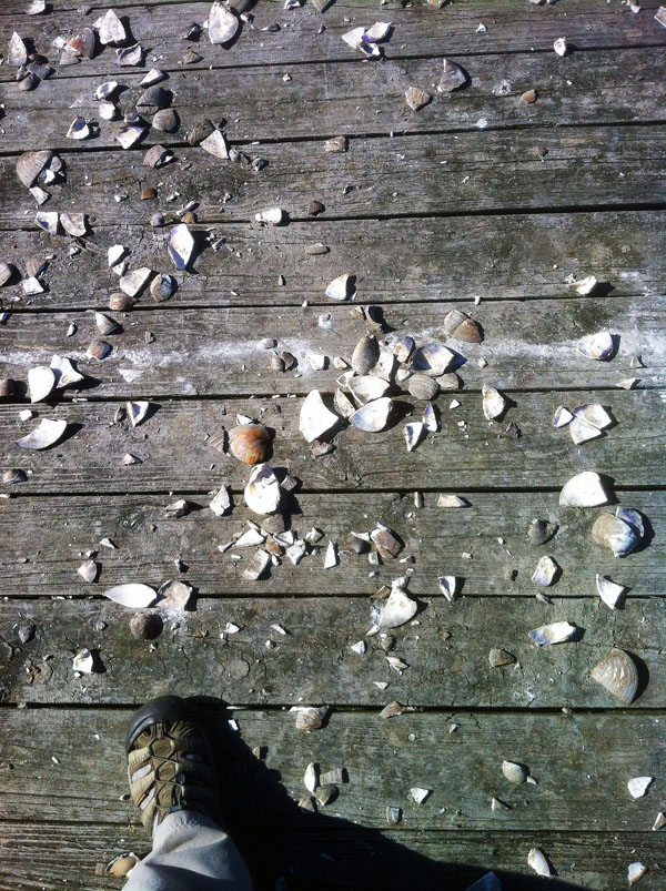
Shattered-Quahogs-Pier-Jekyll-IslandFor clams that try to fly, they end up with more than shattered dreams. How did these clams (Mercenaria mercenaria, also known as quahogs or “hard clams”) end up doing Humpty-Dumpty impressions on a wooden pier? Please read on. (Photograph by Anthony Martin, taken on Jekyll Island, Georgia.)

In a similar way, clams can fly. They just need a little help from other animals that can fly and willingly give them a temporary lift from the earth they and their molluscan relatives have known for all of their evolutionary history. Compared to most of our forays into the air, though, these flights are much more limited. Clam aerial exploits are brief and mostly vertical, with little time for them to appreciate the view from above or otherwise experience unusual sensations. They go up, then they come down, and fast.

Clams do not have landing gear. So they can hit the ground hard, especially if their free fall happened after a lengthy trip up into the air and the ground surface is hard: think of a sandflat at low tide, a paved parking lot, or a wooden boardwalk. A a result, the most common end to clam flights is a shattered shell, which is quickly followed by the demise of the clam as it is consumed by the very same animal that bestowed it with flight, however brief and self-serving.

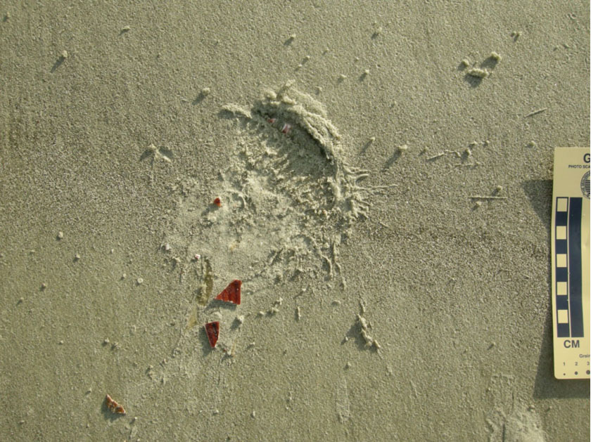
Impact-Trace-Seagull-Clam-DropTraces of a unidirectional vertically oriented clam flight (otherwise known as “falling”) that did not end well for the clam, but worked perfectly for the flying animal that took it for a ride. Notice the impact trace on the hard sandflat, outlining the ribbed shell of the clam (probably Dinocardium robustum) and bits of shell. Most of the probably-still-alive-but-definitely-dying animal  was dragged off to a nearby spot so that its soft parts could be eaten by the same perpetrator that took it for a ride. (Photograph by Anthony Martin, taken on Sapelo Island, Georgia.)

So just what flying animals do such dastardly deeds, taking hapless clams up for a ride, only to drop them to a certain death? By now the gentle reader has probably figured out birds are responsible for this blatant bivalvicide, and some may have already known that seagulls are the most likely culprits. In some coastal areas and during low tides, some seagulls fly over exposed sandflats and mudflats, searching for the outlines of clams buried below the surface. These avian ichnologists then swoop down, land, pick up the clam with their beaks, take off, and then once high enough, they drop them, serving up instant raw clam on the half (or quarter, or eighth) shell. Typically all that is left is a jigsaw puzzle of clamshell pieces and the seagull perpetrator’s footprints, but with the latter only evident on muddy or sandy surfaces amenable to preserving tracks.

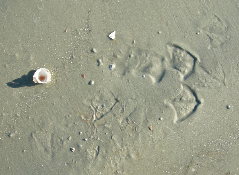
Seagull-Tracks-Eaten-ClamIchnological evidence of who killed the clam, provided by the tracks a laughing gull (Larus altricilla).The other half of the shell was broken by its falling onto the sandflat elsewhere, then the gull carried its clam on the half-shell to a more scenic place for its meal. (Photo by Anthony Martin, taken on Little St. Simons Island, Georgia.)

I found this behavior so compelling that I started my book Life Traces of the Georgia Coast (2013) with a story about a laughing gull (Larus altricilla) and the traces of its unwitnessed predation on an Atlantic cockle (Dinocardium robustum), seagull behavior on the Georgia coast. I was not the first person to note this method of clam-smashing by seagulls, as it has been documented by other scientists in parts of the U.S. and abroad, and has been caught on video. Amazingly, though, despite more than 15 years of visiting the Georgia coast, I had never actually witnessed seagulls dropping clams. instead I had only performed post-mortem forensics, in which I would find broken clamshells on hard sandflats accompanied by seagull tracks, telling tales of murder most fowl.

Video footage of a western gull (Larus occidentalis) picking up a clam, flying up about 10 meters (> 30 feet), and dropping it onto rocks to crack it open. After this doesn’t work the first time – and after shooing away a potential clam-stealing rival – it tries again, and is presumably successful. It’s almost as if this gull is using a scientific methodology, isn’t it? (The videographer is only credited as ‘Trisera’ on the YouTube page, and I don’t know where it was filmed, but suppose it’s on the western coast of the U.S.)

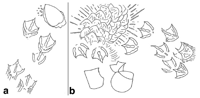
Seagull-Cockle-Predation-DiagramHere’s the first illustration a reader will see in my book, Life Traces of the Georgia Coast (2013, Indiana University Press), which I drew to provide a visual forensic analysis of how an Atlantic cockle met its demise at the hands of – er, I mean, wings and bill of – a laughing gull. Part (a) depicts the gull landing after recognizing the outline of the cockle from the air, stopping, and extracting it from the sandflat. Part (b) shows where the cockle was dropped and broken successfully, accompanied by the gull landing and trampling the area as it enjoyed its clam dinner.

This meant I was more than overdue to get visual confirmation of gulls killing clams, which was finally granted just a few weeks ago during a recent trip to Jekyll Island (Georgia). It was the day after I had given an invited talk at the annual meeting of The Initiative to Protect Jekyll Island environmental group, and while my wife Ruth and I were relaxing before leaving the island, but of course were also observing whatever nature we could.

In that spirit, and while sitting on a deck on the west side of the island and looking at a mudflat (in between swatting sand gnats), we noticed a seagull flying about 10 meters (>30 feet) above a wooden pier. At one point, it paused its ascent, and we saw an object fall from its mouth and down toward the pier. Thunk! We clearly heard the impact of the object correlate with what we saw, and with much excitement realized that we had just witnessed seagull clam-cracking for the first time.

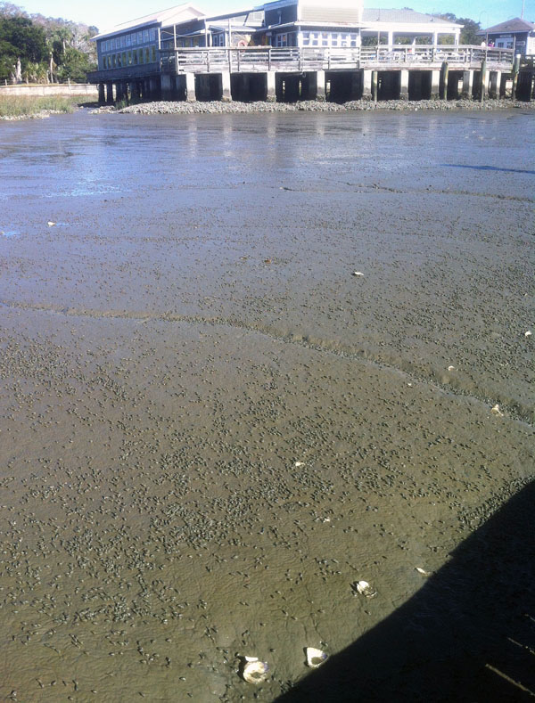
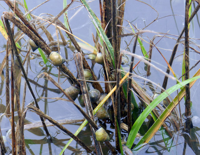
Jekyll-Island-Mudflat-Dead-Clams A mudflat replete with mud snails (probably Ilyanassa obseleta), grazing away and making gorgeous meandering trails on the western side of Jekyll Island (Georgia). But wait, what are those big white chunks on the same surface?

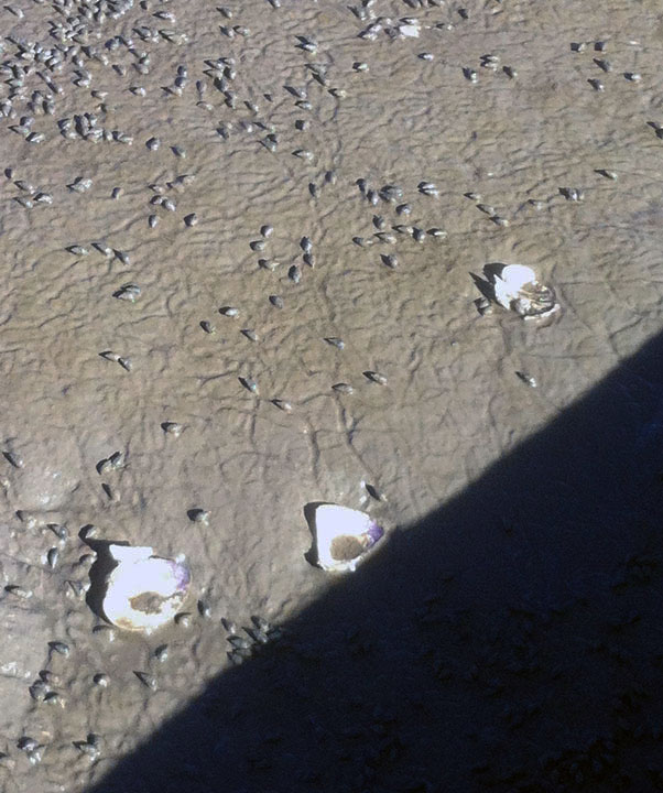
Dead-Clams-Mudflat-Jekyll-IslandWhy, look at that: hard clams (Mercenaria mercenaria) in an unnatural state, i.e., disarticulated, broken, and dead on the surface of the mudflat. These clams normally burrow into and live under the mud, and usually manage to stay intact if they stay below the surface. The pieces of clams here must have bounced off the wooden pier, which is casting a shadow in the lower right-hand side of the picture. (Both preceding photographs by Anthony Martin and taken on Jekyll Island, Georgia.)

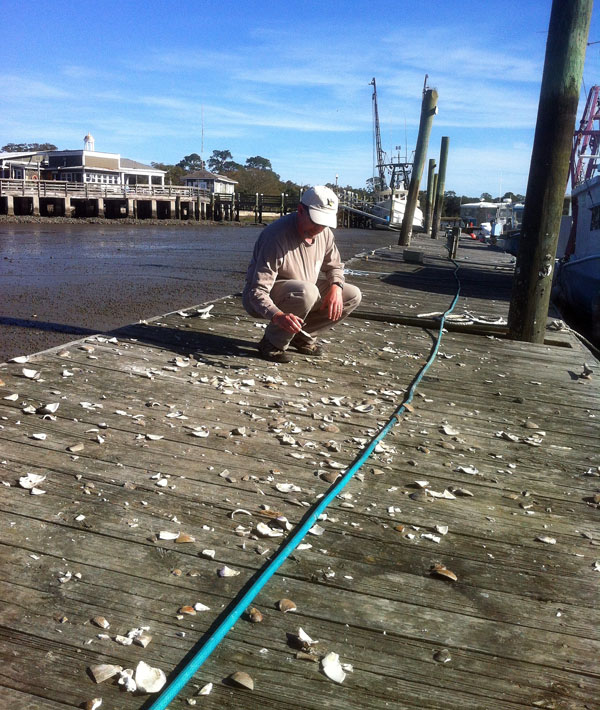
What was most surprising to me about this broken-shell assemblage on the pier was how it was represented only by the hard clam, or quahog (Mercenaria mercenaria). These thick-shelled clams are quite common in sparsely vegetated muddy areas of salt marshes, burrowing into the mud and connecting their siphons to the surface so that they can filter out suspended goodies in the water during high tides. During low tides, however, they become vulnerable to avian predation. Despite being “hidden” in the mud, somehow the seagulls spotted them from the air, landed next to them on the mudflat, and pulled them out of the mud. They then used the nearby pier as an anvil, and the clam’s hard, thick shell unwittingly became its own hammer when they hit the pier after falling from a fatal height.

Shattered-Quahogs-Jekyll-Pier-MartinThe horror, the horror: a clam killing “ground,” thoughtfully supplied by humans for seagulls in the form of a long, hard, wooden pier. (Photograph by Ruth Schowalter and Yours Truly for scale, taken on Jekyll Island, Georgia.)

OK, now it’s time to think about broken clams and deep time. If you found such an assemblage of broken shells of the same species of thick-shelled clams in a geologic deposit, how would you interpret it? Would you think of these broken shells as predation traces, let alone ones made by birds? Which also prompts the question, when did seagulls or other shorebirds start using flight and hard surfaces to open clams? Did it evolve before humans, and if so, was it passed on as a learned behavior over generations as a sort of “seagull culture”?

All of these are good questions paleontologists should ask whenever they look at a concentration of broken fossil bivalves that are all of the same species, and overlapping with the known geologic range of shorebirds. In short, these may not be “just shells,” but evidence of birds using gravity-assisted killing as part of their predation portfolio.

Traces of the Red Queen

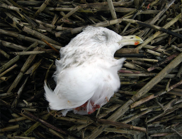
The seagull looked peaceful on that beach, lying on its left side with its eyes closed. Yet it was a permanent quietude, as only its head was there.

This disembodied head stuck out as a white spot with a red edge, perched on top of a pile of dull-brown, dead cordgrass. The torso so recently connected to this head was nowhere to be seen, and I could find no tracks belonging to the gull or any other animal nearby. It looked as if it had been placed there as an object of art, ready for erudite admirers – wine glasses in hand – to comment on its broader themes and nuanced metaphors. To a ichnologist, though, it also spoke of a sudden death, and one likely dealt by a aerial predator.

Seagull-Head-Decapitated-WassawThe place where I saw this gruesome sign was on Wassaw Island, Georgia. Wassaw is the only island on the Georgia coast that was never logged or otherwise developed by European or Americans, hence it retains a more primitive feel compared to most other Georgia islands. You can only get there by boat, and in this instance our boat captain and guide – John Crawford – had taken our field-trip group there to learn about its unique natural history. Because of its intact environments and general lack of human influence on the landscape, I was not surprised to see something new on Wassaw. However, I haven’t seen anything like this since.

Within minutes of arriving on the island, this beheaded seagull presented a little mystery for us. As mentioned before, tracks and the rest of the body were not visible, nor were any droplets of blood around its head, either. Moreover, its dry feathers and the freshness of its fatal wound – a clean severing of its neck vertebrate – also meant it had not washed up on shore. Where did it die, and how did it get there?

After ruling out the land and sea, we looked above the beach, and realized that the attack must have been delivered up there, in the air. We then imagined what could have possessed the bulk, ferocity, and other means to chop through a seagull’s neck while in flight. The list of suspects was a short one, and we quickly narrowed it down to one: a bald eagle.

Our hypothesis was not so far-fetched, as bald eagles don’t just eat fish, but also kill and eat other birds, including gulls. This meant the seagull head we saw that morning was very likely a result of bird-on-bird predation. Extending this a bit further into the evolutionary pasts of these birds, it reflected a time when when their non-avian dinosaur ancestors killed and were killed by similar behaviors, but on the ground.

How did birds evolve flight from non-flighted theropod ancestors? No doubt one of many selection pressures exerted on non-avian dinosaurs was predation. Any means for increasing the likelihood of escape from predators also bestowed a greater probability for passing on genes coding for that “escaping trait” to the next generation of not-quite-flighted dinosaurs.

Of course, flight has evolved for many uses in birds. Nevertheless, making a quick getaway from mortal peril is still one of them. Yet flight has also been used as a means for enhancing predation in the birds that kill other birds, exerting new and different selection pressures on prey. This example of an evolutionary back-and-forth “arms race” between predators and prey is often nicknamed the Red Queen hypothesis, named after Lewis Carroll’s character in Alice in Wonderland. Only now I will change her line (said to a fleeing Alice) about running in place:

Now, here, you see, it takes all the running you can do to keep in the same place.

to a more avian-appropriate one:

Now, here, you see, it takes all the flying you can do to keep in the same place.

Still, In this Georgia-coast example, a more appropriate literary allusion would have been to the Queen of Hearts from Alice in Wonderland, a decapitating character famous for uttering the line, “Off with their heads!” In this sense, the Red Queen and Queen of Hearts meet in the arms race between predators and prey.

Will this “Red Queen of Hearts” scenario happen again during eagle and seagull conflicts? Yes: that is, unless the seagulls’ descendants adapt, which may be followed by the eagles’ descendants adapting to these changes. And on it goes, this evolution of the now blending with the then, a reminder that these days of the dead affect those of the living, as well as those not yet alive.

Erasing the Tracks of a Monster

Life can certainly imitate art, as can life traces. I was reminded of this last week while doing field work on St. Catherines Island (Georgia), and after encountering traces made by two very different animals, alligators and fiddler crabs. What was unexpected about these traces, though, was how they intersected one another in a way that, for me, evoked scenes from the recent blockbuster summer movie, Pacific Rim.

Alligator-Tracks-Fiddler-Crab-Burrows-1

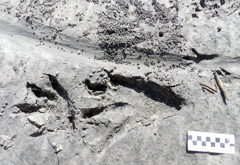
Could these be the tracks of a kaiju, making landfall on the shores of Georgia? Sorry to disappoint you, but they’re just the right-side and very large tracks of an American alligator (Alligator mississippiensis), accompanied by its tail drag-mark, left on a sandy area next to a salt marsh. Note the scale impressions in its rear-foot track, a symbol of the awesome reptilian awesomeness of its tracemaker. But wait: what nefarious nonsense is happening to the tail drag-mark, which is being covered by tiny balls of sand? Who made that hole next to the drag-mark? And what the heck was a raccoon (Procyon lotor) doing in the neighborhood, leaving its track on the tail drag-mark? With such a monster on the loose, shouldn’t that raccoon be hiding in the forest? (Photo by Anthony Martin, taken on St. Catherines Island; scale in centimeters.)

For anyone who has not seen Pacific Rim, you can read what I wrote about its distinctive fictional ichnology here. But what came to my mind while I was doing field work was one of the themes expressed early on in the film: how quickly humanity returned to normalcy following a lull in attacks by gigantic monsters (kaiju) that emerged from the ocean, destroyed major cities, and killed millions of people. It reminded me of how horrific hurricanes can strike a coast, such as the 1893 Sea Islands Hurricane that hit Georgia, but because no hurricane like it has happened there since, coastal developers think it’s hunky-dory to start building on salt marshes.

But enough about malevolent evil as exemplified by kaiju and coastal developers: let’s get back to traces. Last week, I was on St. Catherines Island for a few days with my wife (Ruth) and an undergraduate student (Meredith) to do some field reconnaissance of my student’s proposed study area. The area was covered by storm-washover fans; these are wide, flat, lobe-shaped sandy deposits made by storm waves, which span from the shoreline to more inland on barrier islands. We were trying to find out what traces had been left on these fans – tracks, burrows, scrapings, feces, and so on – which would tell us more about the distribution and behaviors of animals living in and around the washover fans.

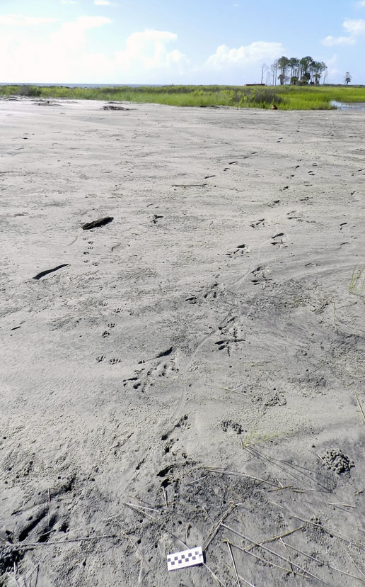
Alligator-Trackway-St-Catherines-2Part of a storm washover fan on St. Catherines Island (Georgia), with the sea to the left and salt marsh (with a patch of forest) in the background. Say, I wonder what made those tracks coming out of the tidal creek and toward the viewer? (Photograph by Anthony Martin.)

It didn’t take long for us to get surprised. Within our first half hour of walking on a washover fan and looking at its traces, we found a trackway left by a huge alligator, split in half by a wavy tail-drag mark. I recognized this alligator from its tracks, as I had seen them in almost exactly the same place more than a year before. Besides their size, though, what was remarkable about these tracks was their closeness to a salt marsh behind the washover fan. When we looked closer, we could see long-established trails cutting through the salt-marsh vegetation, which were the width of a large adult alligator.

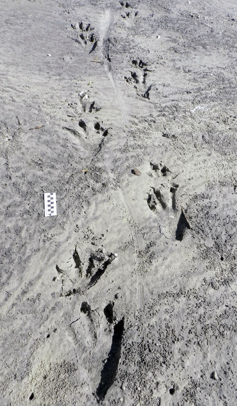
Alligator-Trackway-St-Catherines-1That ain’t no skink: the distinctive tracks and tail drag-mark of a large alligator, strolling through a storm-washover fan and next to a salt marsh. You think these animals are “freshwater only”? Traces disagree. Scale = 10 cm (4 in). (Photograph by Anthony Martin, taken on St. Catherines Island, Georgia.)

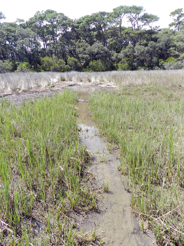
Alligator-Trail-Salt-Marsh-SCIAlligator trail cutting through a salt marsh. Trail width was about 45-50 cm (18-20 in), which is about twice as wide as a raccoon trail. And it wasn’t made by deer or feral hogs either, because, you know, alligators. (Photograph by Anthony Martin, taken on St. Catherines Island, Georgia.)

So although the conventional wisdom about alligators is that these are “freshwater-only” animals, their traces keep contradicting this assumption. Sure enough, in the next few days, we saw more alligator tracks of varying sizes going into and out of tidal creeks, salt marshes, and beaches.

Based on a few traits of these big tracks, such as their crisp outlines (including scale impressions), the alligator had probably walked through this place just after the tide had dropped, only a couple of hours before we got there. But when we looked closer at some of the tracks along the trackway, we were astonished to see that something other than the tides had started to erase them, causing these big footprints to get fuzzy and almost unrecognizable.

The culprits were sand fiddler crabs (Uca pugilator), which are exceedingly abundant at the edge of the storm-washover fans closest to the salt marshes. These crabs are industrious burrowers, making J-shaped burrows with circular outlines corresponding to their body widths. They also scrape the sandy surfaces outside of their burrows to eat algae in the sand, then roll up that sand into little balls, which they deposit on the surface.

In this instance, after this massive alligator had stomped through their neighborhood, they immediately got back to work: digging burrows, scraping the surface, and making sand balls. Within just a few hours, parts of the alligator trackway was obscured. If these parts had been seen in isolation, not connected to the clear tracks and tail drag mark, I doubt we would have identified these slight depressions as large archosaur tracks.

Alligator-Tracks-Burrowed-Fiddler-CrabsHey, what’s going on here? Who would dare to erase and fill in giant alligator tracks? Don’t they know who they’re dealing with? (Photograph by Anthony Martin, taken on St. Catherines Island, Georgia.)

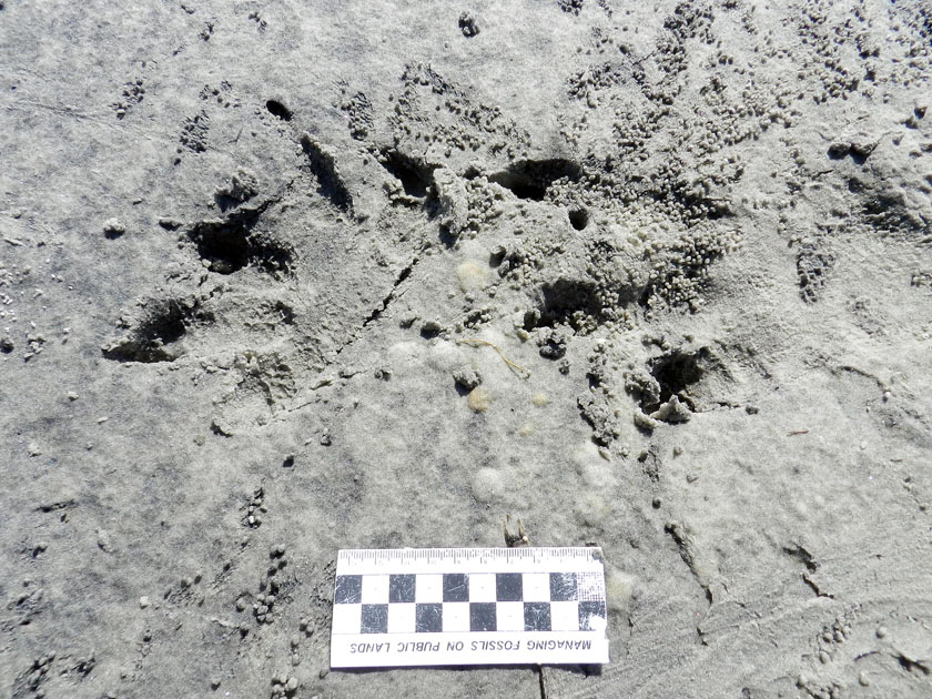
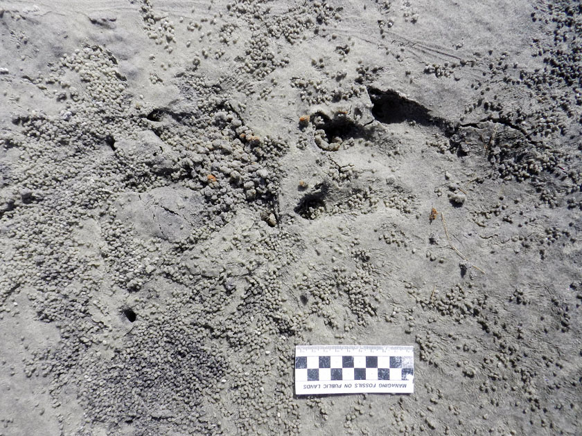
Alligator-Tracks-Destroyed-Fiddler-Crab-Burrows-1Going, going, gone: alligator tracks nearly obliterated by burrowing, surface scraping, and sand balls caused by feeding of sand fiddler crabs (Uca pugilator). (Photograph by Anthony Martin, taken on St. Catherines Island, Georgia; scale in centimeters.)

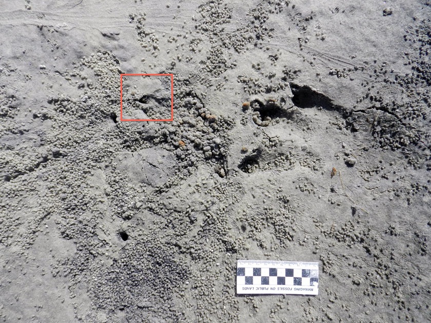
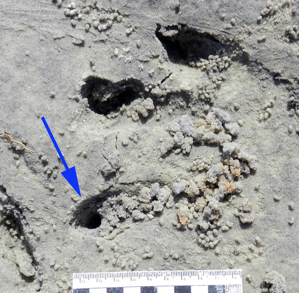
What was even neater, though, was how some of the fiddler crabs took advantage of homes newly created by this alligator. In at least a few tracks, we could see where fiddler crabs had taken over the holes caused by alligator claw marks. In other words, fiddler crabs saw these, said, “Hey, free hole!”, and moved in, not caring what made them.

Alligator-Tracks-Destroyed-Fiddler-Crab-BurrowsDon’t believe me about fiddler crabs moving into alligator claw marks? OK, then what’s that I see poking out of that alligator claw mark (red square)? (Photograph by Anthony Martin, taken on St. Catherines Island, Georgia; scale in centimeters.)

Fiddler-Crab-Burrow-Alligator-Claw-MarkWhy, it’s a small sand fiddler crab! Does it care that its new home is an alligator claw mark? Nope. Does ichnology rule? Yup. (Photograph by Anthony Martin, taken on St. Catherines Island, Georgia.)

Fiddler-Crab-Burrow-Alligator-Claw-2Need a free burrow? Then why start digging a new one when alligator claw marks (arrow) gives you a nice “starter burrow”? Notice the sculpted, round outline, showing the claw mark was modified by a crab. Also check out the sand balls left outside of the other claw marks, meaning these have probably been occupied and mined for food by fiddler crabs, too. (Photograph by Anthony Martin, taken on St. Catherines Island, Georgia; scale in centimeters.)

As a paleontologist, the main lesson learned from this modern example that can be applied to fossil tracks, is this: any tracks made in the same places as small, burrowing invertebrates – especially in intertidal areas – might have been destroyed or otherwise modified immediately by the burrowing and feeding activities of those much smaller animals. The secondary lesson is on how large vertebrate tracks can influence the behaviors of smaller invertebrates, resulting in their traces interacting and blending with one another.

More symbolically, though, these alligator tracks and their erasure by fiddler crabs also conjured thoughts of fictional and real analogues: Pacific Rim and coastal development, respectively. With regard to the latter, it felt too much like how, as soon as a hurricane (a meteorological “monster”) passes through a coastal area, we begin to talk about rebuilding in a way that, on the surface, wipes out all evidence that a hurricane ever happened.

Yet unlike fiddler crabs, we have memories, we have records – including the plotted “tracks” of hurricanes – and thanks to science, we can predict the arrival of future “monsters.” So the preceding little ichnological story also felt like a cautionary tale: pay attention to the tracks while they are still fresh, and be wary of those that vanish too quickly.

Teaching on an Old Friend, Sapelo Island

(This post is the fourth in a series about a spring-break field trip taken last week with my Barrier Islands class, which I teach in the Department of Environmental Studies at Emory University. The first three posts, in chronological order, tell about our visits to Cumberland Island, Jekyll Island, and Little St. Simons and St. Simons Islands. For the sake of conveying a sense of being in the field with the students, these posts mostly follow the format of a little bit of prose – mostly captions – and a lot of photos.)

When planning a week-long trip to the Georgia barrier islands with my students, I knew that one island – Sapelo – had to be included in our itinerary. Part of my determination for us to visit it was emotionally motivated, as Sapelo was my first barrier island, and you always remember your first. But Sapelo has much else to offer, and because of these many opportunities, it is my favorite as an destination for teaching students about the Georgia coast and its place in the history of science.

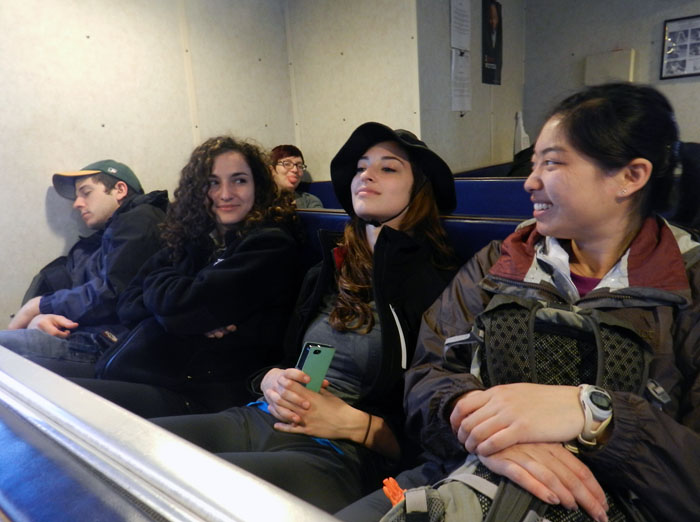
Getting to Sapelo Island requires a 15-minute ferry ride, all for the low-low price of $2.50. (It used to cost $1.00 and took 30 minutes. My, how times have changed.) For my students, their enthusiasm about visiting their fourth Georgia barrier island was clearly evident (with perhaps a few visible exceptions), although photobombing may count as a form of enthusiasm, too.

I first left my own traces on Sapelo in 1988 on a class field trip, when I was a graduate student in geology at the University of Georgia. My strongest memory from that trip was witnessing alligator predation of a cocker spaniel in one of the freshwater ponds there. (I suppose that’s another story for another day.) Yet I also recall Sapelo as a fine place to see geology and ecology intertwining, blending, and otherwise becoming indistinguishable from one another. This impression will likely last for the rest of my life, reinforced by subsequent visits to the island. This learning has always been enhanced whenever I’ve brought my own students there, which I have done nearly every year since 1997.

As a result of both teaching and research forays, I’ve spent more time on Sapelo than all of the other Georgia barrier islands combined. Moreover, it is not just my personal history that is pertinent, but also how Sapelo is the unofficial “birthplace” of modern ecology and neoichnology in North America. Lastly, Sapelo inspired most of the field stories I tell at the start of each chapter in my book, Life Traces of the Georgia Coast. In short, Sapelo Island has been very, very good to me, and continues to give back something new every time I return to it.

So with all of that said, here’s to another learning experience on Sapelo with a new batch of students, even though it was only for a day, before moving on to the next island, St. Catherines.

(All photographs by Anthony Martin and taken on Sapelo Island.)

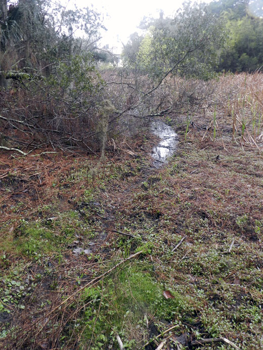
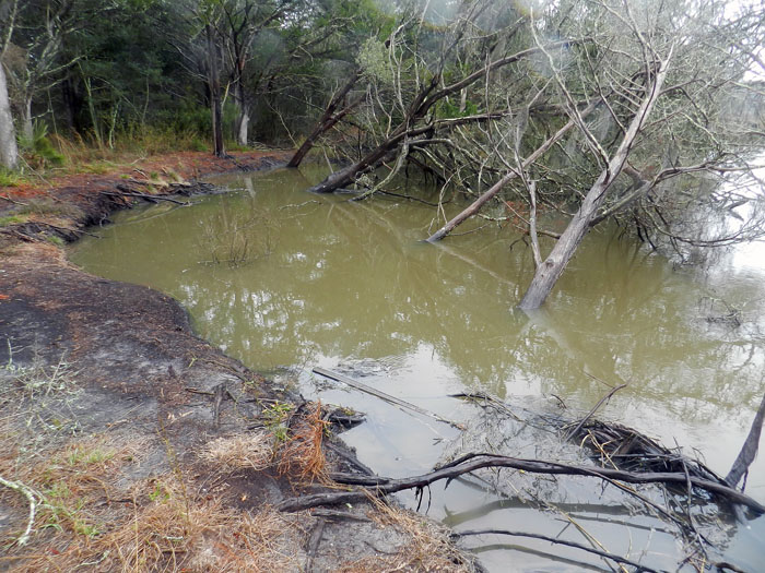
Next to the University of Georgia Marine Institute is a freshwater wetland, a remnant of an artificial pond created by original landowner R.J. Reynolds, Jr. More importantly, this habitat has been used and modified by alligators for at least as long as the pond has been around. For example, this trail winding through the wetland is almost assuredly made through habitual use by alligators, and not mammals like raccoons and deer, because, you know, alligators.

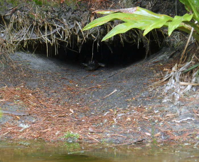
Photographic evidence that alligators, much like humans prone to wearing clown shoes, will use dens that are far too big for them. This den was along the edge of the ponded area of the wetland, and has been used by generations of alligators, which I have been seeing use it on-and-off since 1988.

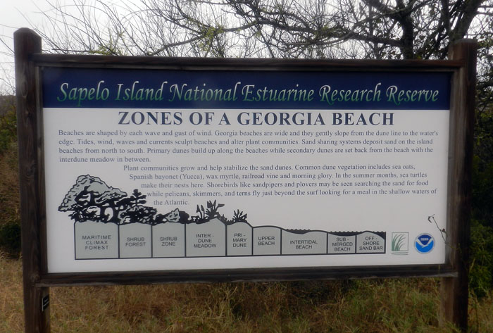
An idealized diagram of ecological zones on Sapelo Island, from maritime forest to the subtidal. This sign provided a good field test for my students, as they had already (supposedly) learned about these zones in class, but now could experience the real things for themselves. And yes, this will be on the exam.

When it’s high tide in the salt marsh, marsh periwinkles (Littoraria irrorata) seek higher ground, er, leaves, to avoid predation by crabs, fish, and diamondback terrapins lurking in the water. Here they are on smooth cordgrass (Spartina alterniflora), and while there are getting in a meal by grazing on algae on the leaves.

Erosion of a tidal creek bank caused salt cedars (which are actually junipers, Juniperus virginiana) to go for their first and last swim. I have watched this tidal creek migrate through the years, another reminder that even the interiors of barrier islands are always undergoing dynamic change.

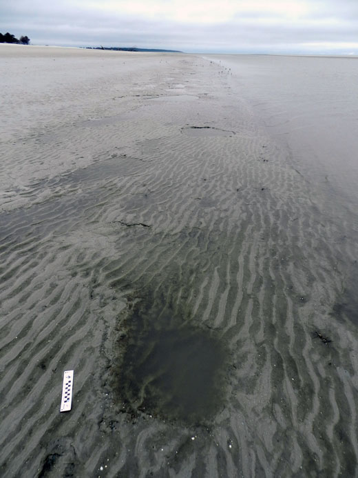
OK, I know what you’re thinking: where’s the ichnology? OK, how about these wide, shallow holes exposed in the sandflat at low tide? However tempted you might be to say “sauropod tracks,” these are more likely fish feeding traces, specifically of southern stingrays. Stingrays make these holes by shooting jets of water into the sand, which loosens it and reveals all of the yummy invertebrates that were hiding there, followed by the stingray chowing down. Notice that some wave ripples formed in the bottom of this structure, showing how this stingray fed here at high tide, before waves started affecting the bottom in a significant way.

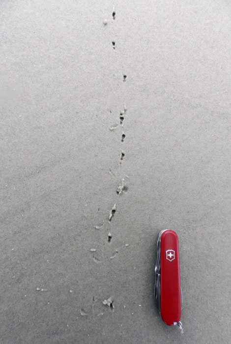
Here’s more ichnology for you, and even better, traces of shorebirds! I am fairly sure these are the double-probe beak marks of a least sandpiper, which may be backed up by the tracks associated with these (traveling from bottom to top of the photo). But I could be wrong, which has happened once or twice before. If so, an alternative tracemaker would be a sanderling, which also makes tracks similar in size and shape to a sandpiper, although they tend to probe a lot more in one place.

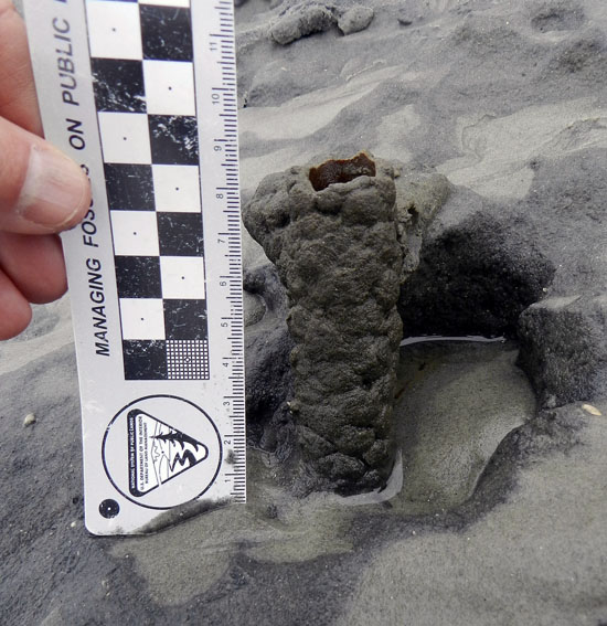
Just in case you can’t get enough ichnology, here’s the lower, eroded shaft of a ghost-shrimp burrow. Check out that burrow wall, reinforced by pellets. Nice fossilization potential, eh? This was a great example to show my students how trace fossils of these can be used as tools for showing where a shoreline was located in the geologic past. And sure enough, these trace fossils were used to identify ancient barrier islands on the Georgia coastal plain.

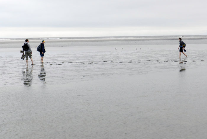
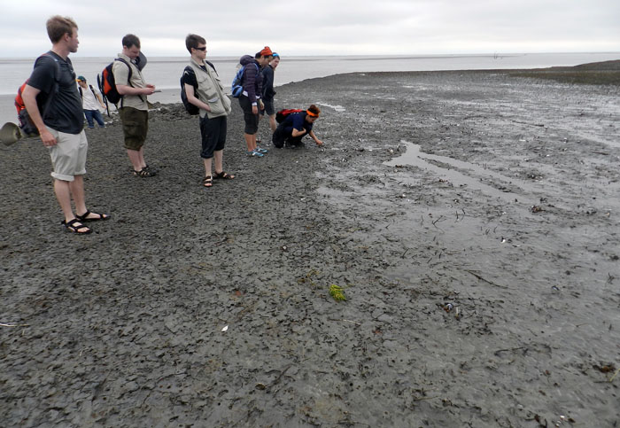
Understandably, my students got tired of living vicariously through various invertebrate and vertebrate tracemakers of Sapelo, and instead became their own tracemakers. Here they decided to more directly experience the intertidal sands and muds of Cabretta Beach at low tide by ambulating through them. Will their tracks make it into the fossil record? Hard to say, but I’ll bet the memories of their making them will last longer than any given class we’ve had indoors and on the Emory campus. (No offense to those other classes, but I mean, you’re competing with a beach.)

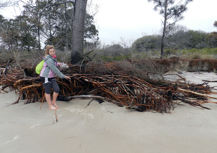
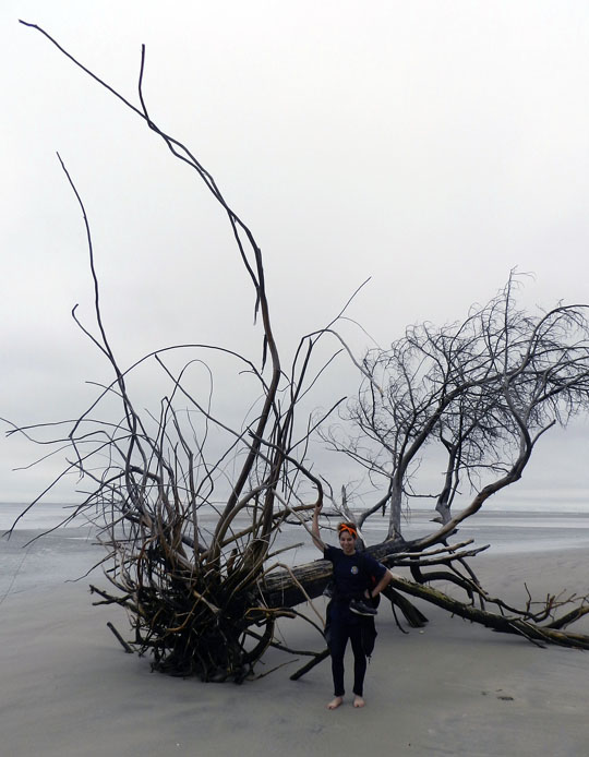
The north end of Cabretta Beach on Sapelo is eroding while other parts of the shoreline are building, and nothing screams “erosion!” as loudly as dead trees from a former maritime forest with their roots exposed on a beach. Also, from an ichnological perspective, the complex horizontal and vertical components of the roots on this dead pine tree could be compared to trace fossils from 40,000 year-old (Pleistocene) deposits on the island. Also note that at this point in the trip, my students had not yet tired of being “scale” in my photographs, which was a good thing for all.

Another student eager about being scale in this view of a live-oak tree root system. See how this tree is dominated by horizontal roots? Now think about how trace fossils made by its roots will differ from those of a pine tree. But don’t think about it too long, because there are a few more photos for you to check out.

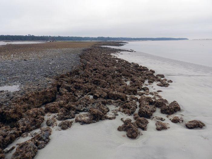
Told you so! Here’s a beautifully exposed, 500-year-old relict marsh, formerly buried but now eroding out of the beach. I’ve written about this marsh deposit and its educational value before, so will refrain from covering that ground again. Just go to this link to learn about that.

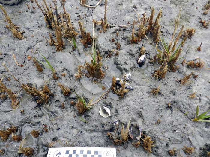
OK geologists, here’s a puzzler for you. The surface of this 500-year-old relict marsh, with its stubs of long-dead smooth cordgrass and in-place ribbed mussels (Guekensia demissa), also has very-much-live smooth cordgrass living in it and sending its roots down into that old mud. So if you found a mudstone with mussel shells and root traces in it, would you be able to tell the plants were from two generations and separated by 500 years? Yes, I know, arriving at an answer may require more beer.

Although a little tough to see in this photo, my students and I, for the first time since I have gone to this relict marsh, were able to discern the division between the low marsh (right) and high marsh (left). Look for the white dots, which are old ribbed mussels, which live mostly in the high marsh, and not in the low marsh. Grain sizes and burrows were different on each part, too: the high marsh was sandier and had what looked like sand-fiddler crab burrows, whereas the low marsh was muddier and had mud-fiddler burrows. SCIENCE!

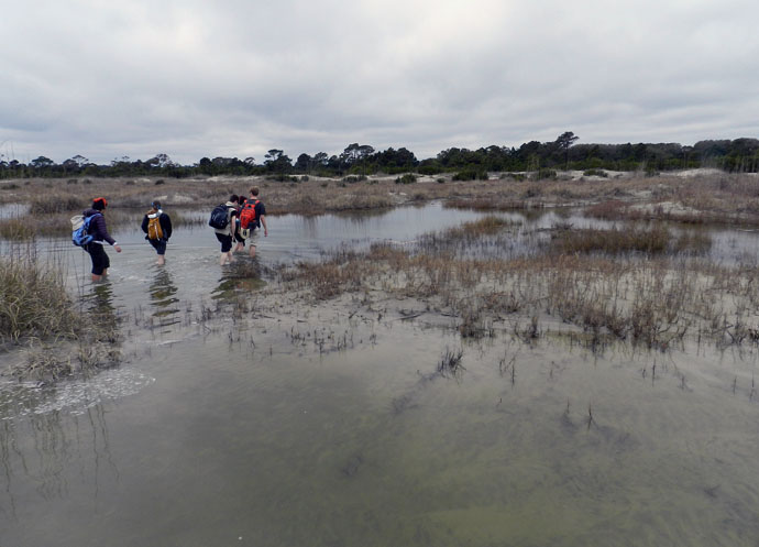
At the end of a great day in the field on Sapelo, it was time to do whatever was necessary to get back to our field vehicle, including (gasp!) getting wet. The back-dune meadows, which had been inundated by unusually high tides, presented a high risk that we might experience a temporary non-dry state for our phalanges, tarsals, and metatarsals. Fortunately, my students bravely waded through the water anyway, and sure enough, their feet eventually dried. I was so proud.

So what was our next-to-last stop on this grand ichnologically tainted tour of the Georgia barrier islands? St. Catherines Island, which is just to the north of Sapelo. Would it reveal some secrets to students and educators alike? Would it have some previously unknown traces, awaiting our discovery and description? Would any of our time there also involve close encounters with large reptilian tracemakers? Signs point to yes. Thanks for reading, and look for that next post soon.


Alien Invaders of the Georgia Coast

(This is the first in a series of posts about invasive species on the Georgia barrier islands, their traces, the ecological impacts of these traces, and why people should be aware of both their traces and impacts.)

Paleontologists like me face a challenge whenever we study modern environments while trying to learn how parts of these environments might translate into the geologic record. Sure, we always have to take into account taphonomy (fossil preservation), through which we acknowledge that nearly none of the living and dead bodies we see in a given environment will become fossilized; relatively few of their tracks, trails, burrows, or other traces are likely to become trace fossils, either.

Because of this pessimistic (but realistic) outlook, paleontologists often rub a big eraser onto whatever we draw from a modern ecosystem, telling ourselves what will not be there millions of years from now. We then retroactively apply this concept – a part of actualism or, more polysyllabically, uniformitarianism – to what happened thousands or millions of years ago. When paleontologists do this, they assume that today’s processes are a small window through which we can peer, giving insights into processes of the pre-human past.

Feral horse (Equus caballus) tracks crossing coastal dunes on Cumberland Island, Georgia. During their evolutionary history, horses originated in North America and populations migrated to Asia, but populations in North America went extinct during the Pleistocene Epoch about 10,000 years ago. Using the perspective of geologic time, then, could someone argue that horses are actually “native,” and these feral populations are restoring a key part of a pre-human Pleistocene landscape? (Photograph by Anthony Martin.)

However, a huge complication in our quest for actualism is this reality: nearly every ecosystem we can visit on this planet is a hybrid of native and alien species, the latter introduced – intentionally or not – by us. Thus when we watch modern species behaving in the context of their environments, we always need to always ask ourselves how non-native species have cracked the window through which we squint, through the past darkly.

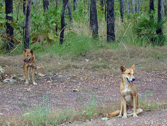
This theme is considered in Charles C. Mann’s most recent book, 1493: Uncovering the New World Columbus Created, in which he argues how nearly all terrestrial ecosystems occupied by people were permanently altered by the rapid introduction of exotic species worldwide following Columbus’s landfall in the Western Hemisphere. Going even further back, though, the introduction of wild dogs (dingoes) into mainland Australia by humans about 5,000 years ago irrevocably changed the environments of an entire continent. Examples like these show that European colonization and its aftermath in human history during the last 500 years was not the sole factor in the spread of non-native species, and hints at how species invasions have been an integral part of humanity and its movement throughout the world.

Something tells me we’re not in Georgia any more. A male-female pair of dingoes (Canis lupus dingo) pose for a picture in Kakadu National Park, Northern Territory, Australia. Although now considered “native,” dingoes are an example of an invasive species that had a huge impact once brought over by people from southeast Asia about 5,000 years ago. For one, its arrival is linked to the extinction of native carnivorous mammals in the mainland Australia, such as thylacines (Thylacinus cynocephalus) and Tasmanian devils (Sarcophilus harrisii). (Photograph by Anthony Martin.)

Well-meaning (but deluded) designations of “pristine,” “untouched,”and “unspoilt” aside, the Georgia barrier islands are no exception to alien invaders. Moreover, like many barrier-islands systems worldwide, they differ greatly from island to island in: which species of invaders are there; numbers of individuals of each species; and the degree of how these organisms impact island ecosystems and even their geological processes.

Feral cat tracks in back-dune meadows of Jekyll Island, Georgia. Jekyll is one of the few Georgia barrier islands with a significant human presence year-round, hence these cats are descended from domestic cats that were either purposefully or accidentally let loose by residents. What impact do these cats have on native species of animals and ecosystems, and are these effects comparable to those of other invasive species on other islands? Scale = 15 cm (6 in). (Photograph by Anthony Martin.)

This is one of the reasons why I devoted several pages of my upcoming book, Life Traces of the Georgia Coast, to the traces of invasive species – tracks, trails, burrows, and so on – despite their failing an “ecological purity test” for anyone who might prefer to focus on native species and their traces. With regard to invasive species, the genie is out of the bottle, so we might as well study what is there, rather than apply yet another metaphorical eraser to species that are drastically shaping modern ecosystems and affecting the behavior of native species, thus likewise altering their traces.

A large pit of disturbed sand in a back-dune meadow caused by feral hogs (Sus crofa) on St. Catherines Island, Georgia. Because feral hogs are wide-ranging omnivores with voracious appetites, they cause considerable alterations to island habitats, from maritime forests to intertidal beaches. How do these traces affect the behavior and ecology of other species, especially native ones, in such a broad range of environments on the Georgia barrier islands? Can their traces actually alter the geological character of the islands? (Photograph by Anthony Martin.)

What are some of these invasive species? What makes for an “invasive species” versus a mere “exotic species”? How do the traces of invasive species affect native species on the Georgia barrier islands, and the ecology and geology of the islands themselves? And how do paleontologists and geologists figure into the study of invasive species?

These are all questions that I hope to explore in upcoming weeks here, and for the sake of simplicity, I will showcase an invasive species of mammal and its traces each week. Some of the photos shown here serve as a visual teaser of the invasive species and their traces that will be covered: feral horses (Equus caballus), cattle (Bos taurus), hogs (Sus crofa), and cats (Felis domestica). Yes, I know, there are many others, but these four are among the most ecologically significant species, they consist of animals that nearly everyone knows, and – best of all – they make easily identifiable traces. So these fours species will provide a starting point in our learning how the Georgia barrier islands can be used as case studies in the traces and ecological effects of traces made by invasive species.

Trail made by feral cattle (Bos taurus) cutting through a salt marsh and extending to the horizon, providing a clue of how this forest-dwelling animal can travel deeply into and affect marginal-marine environments. How might such traces show up in the geologic record, and was there a species that might have made similar traces on the islands in the recent past? (Photograph by Anthony Martin.)

Fossils in Progress

Despite whatever lamentations are made about the “incompleteness” of the fossil record, fossils are actually quite common. This truism is brought home even more so whenever trace fossils – tracks, burrows, and other evidence of organismal behavior – are included in a fossil checklist (as well they should be) when examining any given outcrop of sedimentary rocks formed in the past 550 million years or so.

For example, many a time I have visited an outcrop described previously as “lacking fossils,” and instead found it filled with trace fossils; hence what people meant was “lacking fossils” equals “no body fossils.” Normally these trace fossils are invertebrate burrows, which might be glibly identified as “worm burrows,” but tracks or other trace fossils may also reveal themselves to those who are looking for them. Indeed, this expectation of finding fossils is such that on occasions when geologists find a sedimentary rock layer devoid of either body or trace fossils, this is odd enough to cause geologists to scratch their heads and ask why.

But how do the former bodily remains of plants or animals, or traces of their behaviors, become preserved as fossils in the first place? This question other related ones are answered by the science of taphonomy. Coined by Russian paleontologist Ivan Yefremov, the etymology of this term stems from Greek, in which taphos ( = burial) and nomos (= law). In such a term, he was thus alluding to an expectation that natural processes that result in fossils becoming preserved are orderly and predictable.

An overview of taphonomy as a field of study would be far too lengthy to explore here, so instead I will use one example from the Georgia coast to show how it is supposed to work. This superb case in point is a relict marsh. It is what’s left of a salt marsh from about 500 years ago, and it has been revealing its nature to paleontologists, geologists, and students for the past few decades.
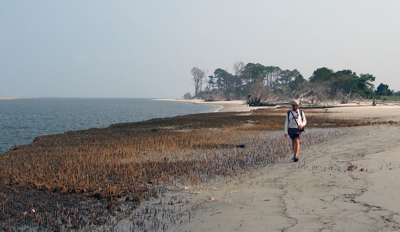
Overall view of relict marsh exposed on Cabretta Beach, Sapelo Island, Georgia. Me for scale, but photo taken 7 years ago, so the scale might now be slightly wider now. (Photograph taken by Ruth Schowalter.)

Just a little more than a week ago, my colleague Steve Henderson and I took a group of students from Emory University to Sapelo Island for a weekend field trip (detailed last week). One of our goals on this trip was to take them to a relict marsh on Cabretta Beach so that they could better appreciate how a sedimentary deposit makes a transition from living ecosystem to inert rock, yet filled with evidence of its formerly teeming life. Similar relict marshes are on St. Catherines Island and other Georgia-coast islands, but when it comes to teaching about taphonomy in the field, I prefer using the one on Sapelo.
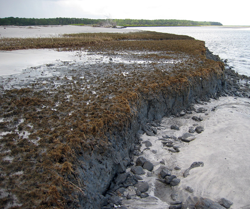
Closer view of relict marsh on Sapelo Island, showing 500-year-old remains of smooth cordgrass (Spartina alterniflora), cross section of its muddy sediments, and quartz sand deposited on top by tides, waves, and wind. (Photograph by Anthony Martin.)

As mentioned in a previous entry, modern salt marsh on the Georgia coast have a few key components that make them among the most productive of all ecosystems: smooth cordgrass (Spartina alterniflora), marsh periwinkles (Littoraria irrorata), mud fiddler crabs (Uca pugnax), and ribbed mussels (Geukensia demissa). So if a Georgia salt marsh were to be buried quickly – say, by a storm that dumps a thick layer of sand on it – what would be preserved? The Cabretta relict marsh partially answers that question, showing us incipient trace and body fossils of these biota. They are not quite fossils, but on their way there, giving us a glimpse of the fossilization process well before it is completed.

For example, the tall, green or golden stalks of smooth cordgrass that we see today, adorned my millions of marsh periwinkles (Littoraria irrorata), are absent from the relict marsh. Only the lowermost ochre-colored stubs and extensive root systems remain, and traces made by the roots below what was the marsh surface.
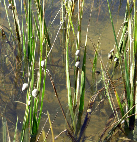
Modern smooth cordgrass (Spartina alterniflora) and its constant companions, marsh periwinkles (Littoraria irrorata) on Sapelo Island, Georgia.
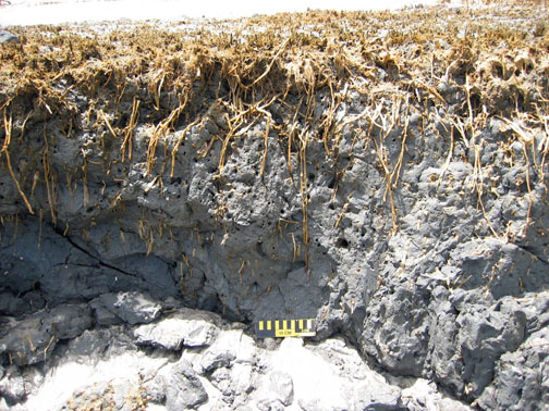
Cross-sectional view of relict marsh, what is left from a formerly magnificent marsh: stubs, roots, root traces, and not many periwinkles. (Both photographs by Anthony Martin.)

Once in a while, I also find old marsh periwinkle shells scattered on the surface of the relict marsh. These are made of calcium carbonate and will dissolve in slightly acidic waters, so these might not last for long once exposed. The real reason for why these tend to disappear quickly, though, is modern hermit crabs. Hermit crabs encounter these periwinkle shells on the relict marsh surface, say “Hey, free shells!”, then happily trot away with these, not caring that their “new” homes are actually 500 years old.

No mud-fiddler crab remains were apparent on the surface, nor have I seen them in 20-30 visits to this relict marsh. This is not surprising, as their exoskeletons are made of chitin and dissolve more quickly than molluscan shells. Nonetheless, their burrows are always abundantly evident on the surface as perfectly round holes, which are sometimes accompanied by new burrows made by modern fiddler crabs, as well as bivalves that will bore into this firmground.
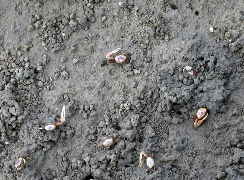
Modern salt marsh surface on Sapelo Island with mud fiddler crabs (Uca pugnax) showing off a few of the behavioral traits they do best: eating, fighting, mating, and burrowing. Note that burrows, surface scrapings, and pellets are a few of the traces they make. Which of these traces get preserved?
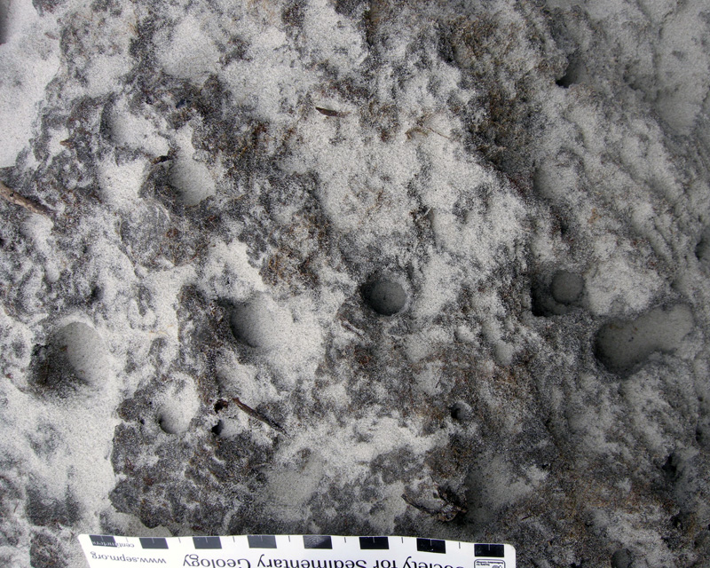
Close-up of eroded relict marsh surface, showing cross-sections of old fiddler-crab burrows now being filled with modern beach sand. Think of how this will look in the fossil record. (Scale in centimeters).
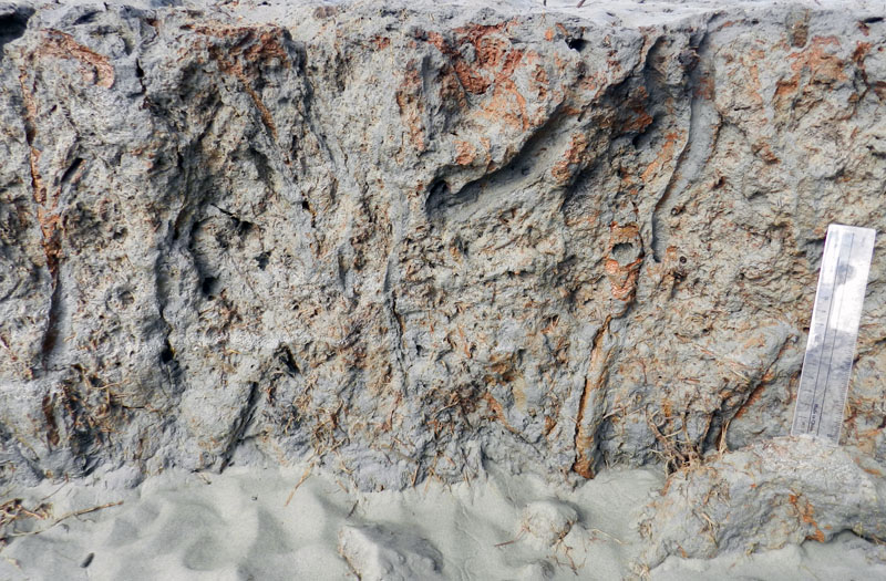
Longitudinal view of former fiddler-crab burrows associated with smooth-cordgrass root traces. Fill the deeper parts of these burrows with sand, and they’re more likely to get preserved as trace fossils. Scale to right is 15 cm (6 in) long. (All photographs by Anthony Martin.)

Modern ribbed mussels are harder for us to see in the field because we would have to wade into soft, deep, sulfurous mud to get close to them, and however amusing that might be, we don’t have time to do our laundry before getting back into our rental vans for the ride home. So the students take our word for it that those mussels are indeed in the marsh, then we point to the old ones clumped on the relict-marsh surface that are still in life position.
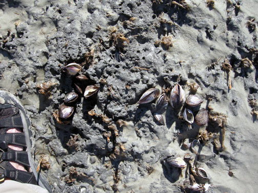
Cluster of ribbed mussels (Guekensia demissa) directly associated with stubs of smooth cordgrass on relict marsh surface. Now that they’re exposed, how long will these shells last on the surface? (Photograph by Anthony Martin.)

Oysters (Crassostrea virginica) are less common in the relict marsh, but given the right exposure, these can be observed on some visits too. These clumps of oyster shells mark the edges of tidal creeks that wound through the marsh.
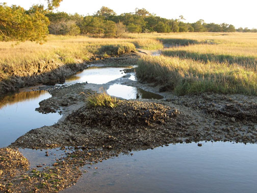
(Top) Modern salt marsh with tidal creek cutting through it and oyster bank exposed at low tide, Sapelo Island.
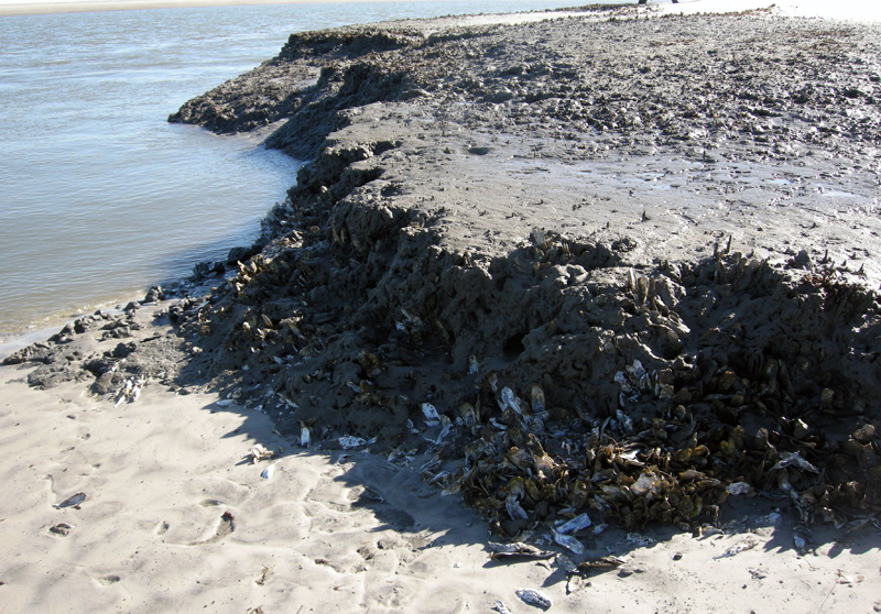
Former oyster bank peeking out of relict marsh, formerly buried for about 500 years, now revealed by erosion of the modern shoreline. (Both photographs by Anthony Martin.)

Because it was all too easy to spot the similarities between this relict marsh and a modern one less than 100 meters (330 feet) from where we stood, I then asked about other differences. For instance, take the fact that we were standing on the relict marsh while discussing its traits: could we do the same in the modern marsh nearby? No, was the universal answer, and I affirmed that they would likely be up to their waists in ribbed-mussel-produced mud. (I asked for volunteers to test this hypothesis, and they very smartly declined.)

This led to a discussion of why the relict marsh could be so firm, which introduced them to the concept of diagenesis: how a sedimentary deposit can change over time, an important consideration in taphonomy. Such alterations are especially apparent in muds, which lose considerable volume as these lose their water content, causing a “softground” to become a “firmground,” then eventually a “hardground.” The students were surprised when I told them that the relict marsh acting as the floor of our “classroom” was likely 2-3 times as thick as what was there now.
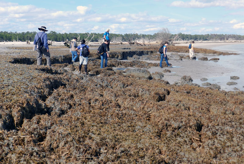
Would these students so blithely walk around on a modern salt marsh? I don’t think so, and please don’t experiment with this yourself. Nevertheless, a relict marsh, thanks to dehydration of its muds and compaction, is just fine for exploring on foot. (Photograph by Anthony Martin.)

We spent only about an hour at the relict marsh before regretfully walking back to our field vehicle, followed by a ferry ride to the mainland part of Georgia and a long drive home to Atlanta. Yet I felt assured that the lessons about taphonomy, ancient environments, ichnology, and diagenesis imparted by this relict marsh encompassed enough material to fill 4-5 class sessions in an indoor classroom. Moreover, if we had been all enclosed by four walls and a ceiling, and without a former marsh underfoot, there was no guarantee that these concepts would be understood or retained.

This is why we geoscientist-educators take our students outside, enriching our collective awareness of how environments change through time and how we piece together the clues left behind from ancient environments. It’s memorable, it’s fun, and it works. But don’t take my word for it. Whether you’re an educator or student, try it yourself sometime, whether on the Georgia coast or elsewhere, and see what happens.

Further Reading

Basan, P.B., and Frey, R.W. 1977. Actual-palaeontology and neoichnology of salt marshes near Sapelo Island, Georgia. In Crimes, T.P., and Harper, J.C. (editors), Trace Fossils 2. Liverpool, Seel House Press: 41-70.

Edwards, J.M. and Frey, R.W. 1977. Substrate characteristics within a Holocene salt marsh, Sapelo Island, Georgia. Senckenbergiana Maritima, 9: 215-259.

Frey, R.W. and P.B. Basan. 1981. Taphonomy of relict Holocene salt marsh deposits, Cabretta Island, Georgia. Senckenbergiana Maritima, 13: 111-155.

Frey, R.W., Basan, P.B. and Scott, R.M. 1973. Techniques for sampling salt marsh benthos and burrows. American Midland Naturalist, 89: 228-234.
Letzsch, W.S. and Frey, R.W. 1980. Deposition and erosion in a Holocene salt marsh, Sapelo Island, Georgia. Journal of Sedimentary Research, 50: 529-542.

Morris, R. W. and H. B. Rollins. 1977. Observations on intertidal organism associations on St. Catherines Island, Georgia. I. General description and paleoecological implications. Bulletin of the American Museum of Natural History, 159: 87-128.

Smith, J.M., and Frey, R.W. 1985. Biodeposition by the ribbed mussel Geukensia demissa in a salt marsh, Sapelo Island, Georgia. Journal of Sedimentary Research, 55: 817-825.