A Mirror Less Distant in Time

(This post is the third in a series about my recent field experiences in Newfoundland, Canada in association with the International Congress on Ichnology meeting (Ichnia 2012) in August, 2012. The first dealt with the unusualness of the Ediacaran Period and the second was about the transition from the Ediacaran to the Cambrian Period for burrowing animals.)

The Ordovician Period, a time represented by rocks from 488-443 million years ago, is an old (and I mean, really old) friend of mine. In my master’s thesis, I studied Ordovician fossils from southwestern Ohio, and for my Ph.D. dissertation, I described and interpreted Ordovician trace fossils and strata in Georgia and Tennessee. Thus for the formative years of my academic career, the Ordovician had a strong presence in my life, overshadowing most other geologically inspired opportunities in my adopted home state of Georgia.
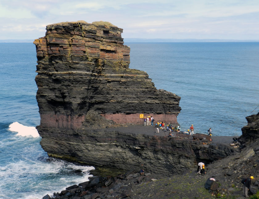
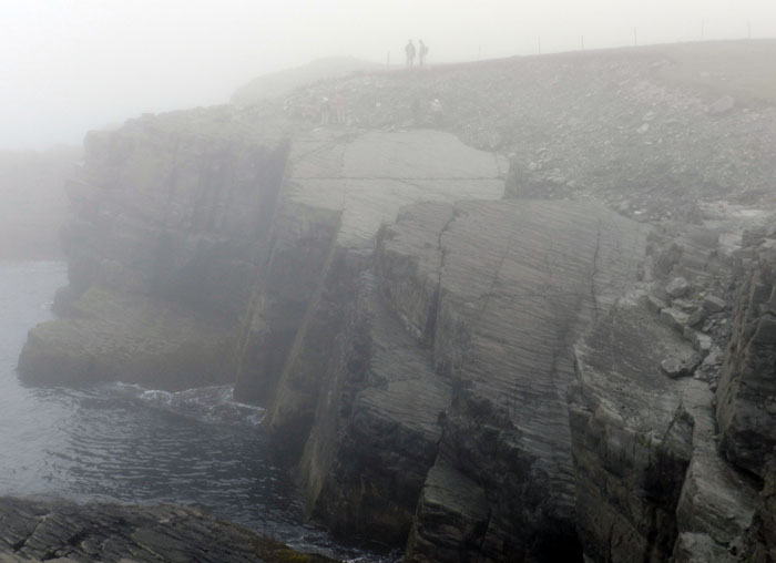
Nice outcrop, eh? It’s composed of Lower Ordovician sedimentary rocks, formed more than 450 million years ago, and is on Bell Island, just offshore from St. Johns, Newfoundland (Canada). It’s a place I had never visited before last month, but its trace fossils took me back to Georgia. How? Guess you’ll have to read some more to find out. (Photograph by Anthony Martin.)

This Ordovician-dominated worldview contrasted with a much later focus on the present-day Georgia barrier islands. Between when I first arrived in Georgia, in 1985 through 1998, my only foray to its coast was a three-day field trip as a graduate student to Sapelo Island in 1988. Fortunately, I’ve been a more regular visitor to Sapelo and other Georgia barrier islands throughout the past 14 years or so, and my geologic perspective has accordingly traveled more than 400 million years forward to study modern plant and animal traces.

However, as I’ve embraced the present and the lessons it offers, what also happened over those years was a personal distancing from the Ordovician. This separation was unfortunate for several reasons. One is that Ordovician body and trace fossils are a mere 1.5-2 hour drive from where I live in the metropolitan Atlanta area, just south of Chattanooga, Tennessee. In contrast, the Georgia coast takes a minimum of four hours to reach by car.

Granted, northwest Georgia was part of my dissertation field area, so my leaving behind a place already prospected, poked, prodded, and otherwise inspected thoroughly more than 20 years ago is understandable and forgivable. Yet a day trip there with a colleague last spring (March 2011), along with a recent field trip to view Ordovician rocks in Newfoundland, Canada last month, reminded me of what was in my geological backyard, while also provoking new thoughts about the intersections between the Ordovician and the Georgia coast.

So what happened during those 20+ years of not studying the Ordovician rocks close to me in Georgia? Well, I gained lots more experience, went to many places with rocks and trace fossils of varying ages, and thus – I like to think – became a better ichnologist. So that leads to an imperiously pronounced statement, so please read it, take it in, and revel in its truth: Ichnology is a skill-based science.

People who study the earth sciences have an old saying, often stated during field trips to students: “The best geologist is the one who’s seen the most rocks.” The same sentiment might be applied to ichnologists. To excel as an ichnologist, it’s not your publication record (let alone impact factors of journals publishing your work), the number or size of your grants, accolades of your peers, “big-idea” review papers, erudite tomes, or any number of trappings imposed by academia that matter. What really matters in becoming a better ichnologist is how many traces you’ve seen, measured, sketched, journaled, photographed, pondered, argued over, and folded into your consciousness.
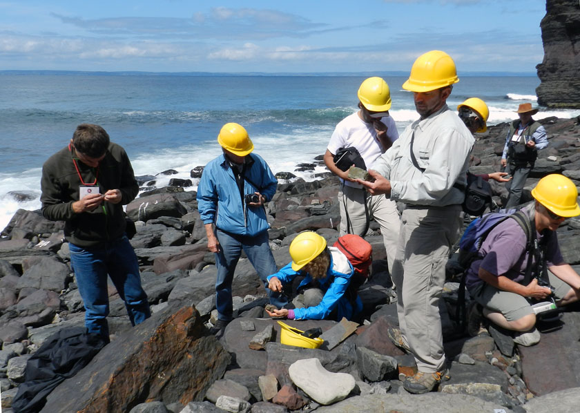
Hey, look – it’s ichnologists, trying to learn more by studying trace fossils in the field! (Photograph by Ruth Schowalter, taken on Bell Island, Newfoundland, Canada.)

Sure, peer review from your colleagues is still an important part of this learning process. Otherwise, as a tracking instructor once told me and other nascent trackers, “When you always track by yourself, you’re always right.” You don’t want to be that ichnologist who gets things wrong, then insists every other ichnologist is wrong, while also imagining that they’re teeming with jealousy over your brilliance. You know, the “they laughed at Galileo, too” fallacy.
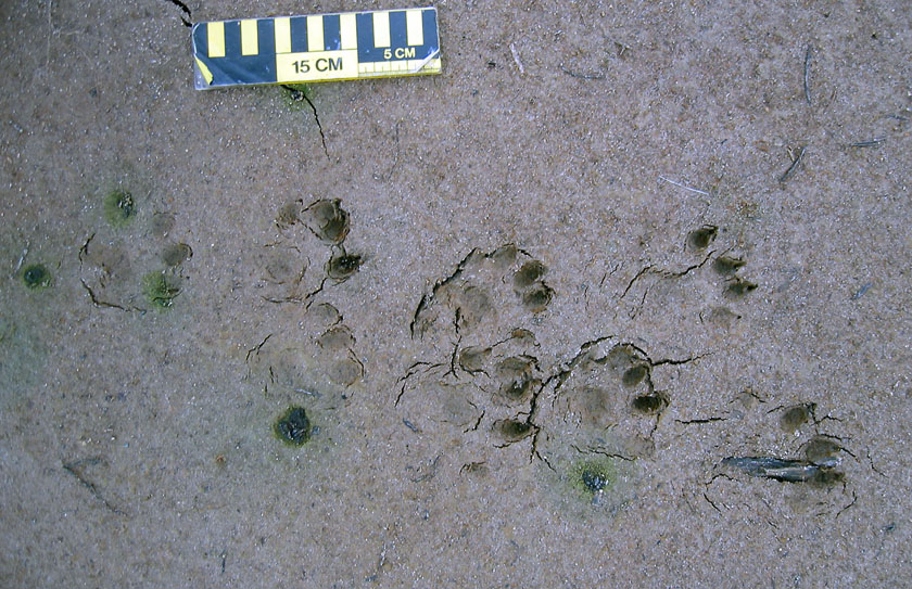
Behold my genius! Only I can clearly see these are the tracks of an eight-legged river otter. Oh, so you think they’re from two four-legged otters, with one following the other? Dolt! Don’t you know who I am?

So am I the best ichnologist? Not just no, but hell no. The acknowledged master of ichnology is Dolf Seilacher. And the main reason I enthusiastically bestow Dr. Seilacher with a crown of back-filled and spreiten-laden burrows is because of the extraordinary amount of experience he has as an ichnologist. Granted, he’s also done all of that academic-type stuff that persuades far less-accomplished members of tenure-review committees to nod their heads with utmost seriousness and say, “Well, I suppose we can make an exception in this case.” But he also has seen, measured, sketched, journaled, photographed, pondered, argued over many, many trace fossils during his 87 years on this planet. Dolf knows traces.

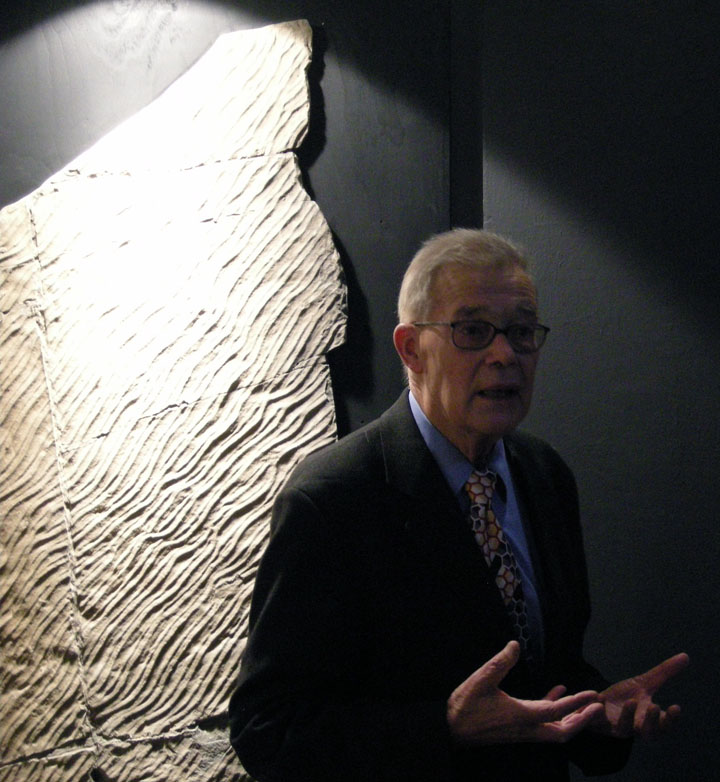
Dolf Seilacher, the widely hailed master of ichnology in the world. Even when he’s wrong, he’s really good at it. (Photograph by Anthony Martin, taken in Krakow, Poland.)

So let’s go back to the Ordovician, and how it relates to Dolf and my claim about the importance of experience in ichnology. In 1997, I invited Dolf to visit Emory University as a distinguished speaker in an evolutionary biology lecture series we had then (since gone defunct, like many things at Emory). Because he had never before visited Georgia, he insisted that we also arrange a field trip for him to see some trace fossils here. So with my friend and colleague, Andy Rindsberg, we organized a day trip to an outcrop near Ringgold, Georgia to look at the Ordovician trace fossils there. Andy had done his master’s thesis on the Ordovician and Silurian trace fossils in that area, and as mentioned earlier, I had done my Ph.D. dissertation about the Ordovician rocks, in which I interpreted them mostly through an ichnological lens.
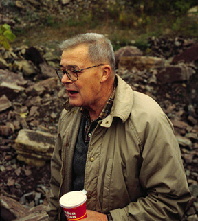
Dolf Seilacher in Georgia (USA) for the first time in November 1997, coffee in one hand and a trilobite burrow in the other. See all of those Ordovician rocks in the background? Even though he’d never been there before, he noticed trace fossils in them in less time than most of us take to read a Huffington Post headline. Gee, you think it had anything to do with his experience? (Photograph by Anthony Martin, taken near Ringgold, Georgia. And just so you know, no paleontologists were “Dolfed” in this photo.)

Andy and I knew the rocks and their trace fossils at this outcrop better than anyone in the world. Yet within five minutes of arriving at the outcrop, Dolf laid his hand on a large slab of Ordovician rock and began talking matter-of-factly about the trilobite burrows in it. Andy and I looked at each other, and said (almost simultaneously), “Trilobite burrows?”

Dolf was right. This rock and many others there were filled with circular, back-filled burrows, which were made by small trilobites that burrowed into mudflats more than 400 million years ago. During a futile attempt to disprove him the following year, Andy and I  found these burrows connected to trackways, and one even ended in a resting trace, perfectly outlining the body of a small trilobite. (Did I mention Dolf was right?)
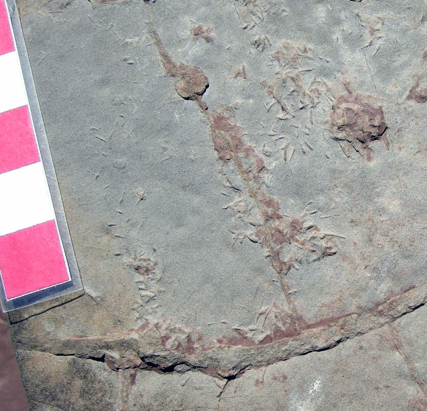
Burrow (upper right, circular structure) connected to tracks made by little legs from a little trilobite. Trace fossils are on the bottom of a sandstone from the Upper Ordovician Sequatchie Formation of northwest Georgia. Scale in centimeters. (Photograph by Anthony Martin.)

Later on that same day, we looked more carefully at some other fossil burrows at the outcrop. These broad, banana-shaped trace fossils were ones that Andy and I had noted in our respective studies, called Trichophycus. Dolf continued his trilobite–tracemaker theme, insisting that these were also trilobite burrows. This idea was supported by scratchmarks on the burrow walls, which linked the burrows to the small legs of whichever arthropod lived in the burrows. Again, trilobites made sense as the tracemakers, and we haven’t yet found a reason why this would be wrong.
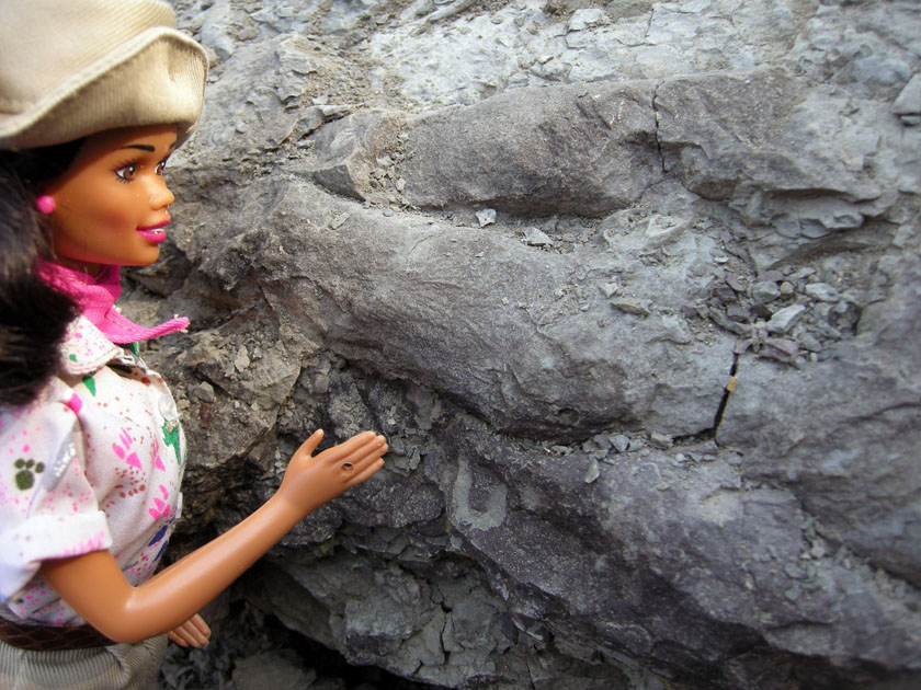
Trusted field assistant Paleontologist Barbie, pointing to a cluster of Trichophycus (interpreted as trilobite burrows) in the Sequatchie Formation of northwest Georgia. She is pointing to some scratchmarks on the burrow walls, which are preserved in natural casts of the burrows. (Photograph by Anthony Martin.)

Almost 13 years later, in March 2011, Andy and I went back to this same Ringgold outcrop to re-study the trace fossils there, done in preparation for a presentation he gave the next month at a regional Geological Society of America meeting (abstract here). He and I were surprised at how much the outcrop had changed since we last visited. Vegetation, particularly of the thorny variety, covered the ground and impeded our progress. Nonetheless, we found many excellent examples of trilobite burrows (Trichophycus), a beautiful trilobite resting trace (Rusophycus), and, for the first time for either of us, a sea-star resting trace.
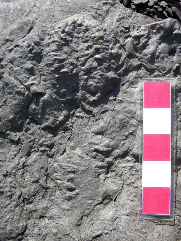
Resting trace of a trilobite (Rusophycus), with a small part of its trackway leading to the trace, in the Upper Ordovician Sequatchie Formation of northwest Georgia. These trace fossils are preserved as natural casts on the bottom of a sandstone, so you’re seeing the underside of where the trilobite hunkered down more than 400 million years ago. (Photograph by Anthony Martin.)
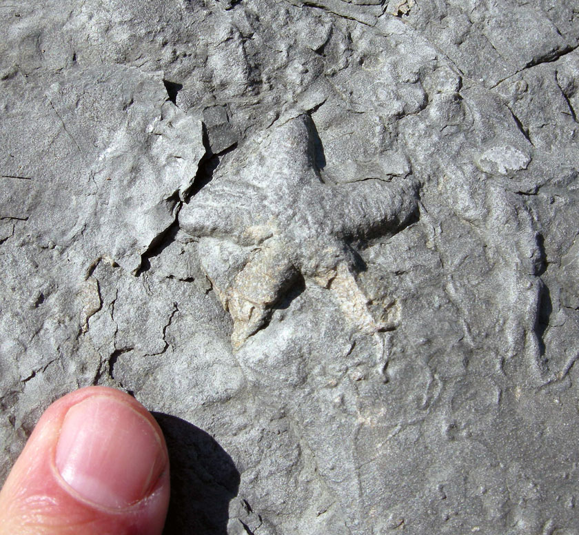
Resting trace of a sea star (Asteriacites) in the Upper Ordovician Sequatchie Formation of northwest Georgia. This trace fossil, like that of the trilobite resting trace, is also preserved as natural casts on the bottom of a sandstone, so you’re looking underneath where the sea star moved into the mud. (Photograph by Anthony Martin.)

Our discovery of the latter two trace fossils – the trilobite and sea-star resting traces – took me from the Ordovician to the Georgia coast and back again. Throughout the late 1980s, I recall my Ph.D. advisor, Robert (“Bob”) Frey placing many of his articles in my graduate-student mailbox, all of which dealt with the traces of the modern Georgia coast. That’s odd, I thought. What did the traces of the modern Georgia coast have to do with these 440-million-year-old rocks?

In my limited worldview at the time, I did not see that the Georgia barrier islands and their traces composed a mirror, however removed by time, for looking into that Ordovician past. But eventually, given enough articles read, field work done, and trace fossils examined at these Ordovician outcrops, I slowly realized these 440-million-year-old rocks had been formed in estuaries, similar to those along the Georgia coast. When I first published an article about these rocks and their trace fossils in 1993 (link here), these strata represented the oldest known estuary deposits in the world, and some of the trace fossils could be readily compared to those on the Georgia coast. The beauty of this realization was that Frey, a master ichnologist in his own right and a contemporary of Seilacher, had allowed me to discover it for myself: he just provided the clues.

Remember that small, circular trilobite burrow with tracks connecting to it? Now compare it to the same sort of traces made by a modern beach mole crab (Albunea paretii), which left its burrow on the right, walked to the left, and is here rapidly burying itself in the sand. Scale in centimeters. (Photograph by Anthony Martin, taken on Sapelo Island, Georgia.)
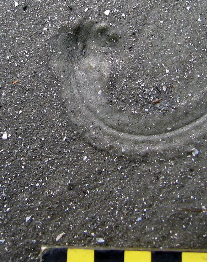
Resting trace and attached trackway of a juvenile horseshoe crab (or limulid, specifically Limulus polyphemus). So think about a similarly sized trilobite making this, and what the bottom of the trace would like like, then compare it to the Ordovician trilobite resting trace fossil shown earlier. Scale in centimeters. (Photograph by Anthony Martin, taken on Sapelo Island, Georgia.)
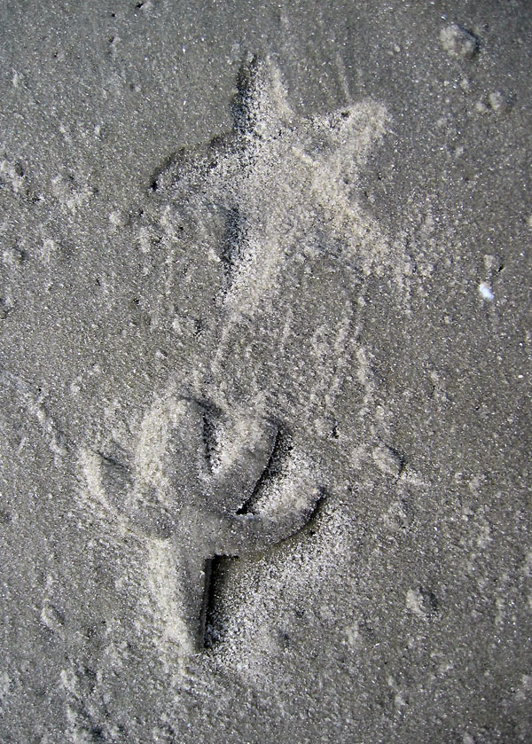
Resting trace of a lined sea star (Luidia clathrata), with the original tracemaker just below its trace. This sea star was stuck above the high tide mark, burrowed into the underlying moist sand, but then tried to move to a better place once its spot started to dry out. Now compare this resting trace to the Ordovician trace fossil shown before. No scale, but sea star is about 8-10 cm wide. (Photograph by Anthony Martin, taken on Sapelo Island, Georgia.)

The following year and only a month ago (August 2012), Andy and I had another Ordovician learning opportunity presented to us, but this time in Newfoundland, Canada. A day trip to see Ordovician rocks and trace fossils on Bell Island, just a 30-minute ferry ride from St. Johns, Newfoundland, was a welcome break from the butt-numbing sessions of the previous two days of the Ichnia 2012 conference at Memorial University.

In our first few minutes at the outcrop and its numerous boulders – spoil piles from an iron-ore mine – we realized that one of the dislodged slabs in front of me was loaded with specimens of Trichophycus. It was a pleasant surprise to get reacquainted with this trace fossil, and in a place far away both geographically and experientially from Georgia.

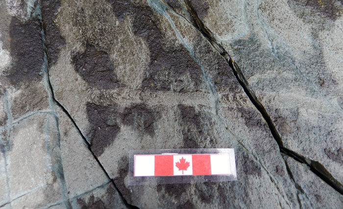
Multiple specimens of Trichophycus in Lower Ordovician rocks of Newfoundland, Canada, preserved as natural casts of the burrows. See all of those scratchmarks on the burrow walls? These were also made by trilobites, but probably different ones from those in Georgia. Scale in centimeters (and that ain’t no real maple leaf.) (Photograph by Anthony Martin.)
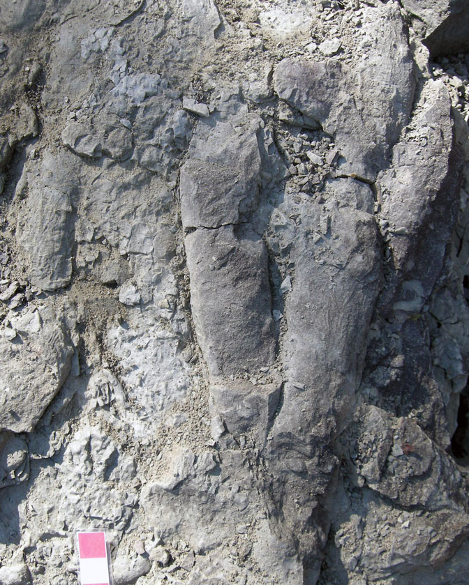
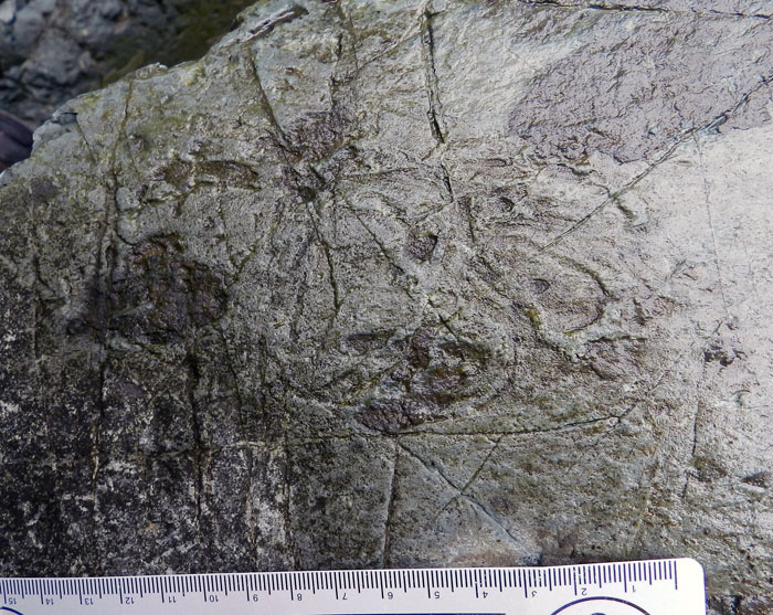
Multiple specimens of Trichophycus in the Upper Ordovician Sequatchie Formation of Georgia, USA, also preserved as natural casts of the burrows and showing some scratchmarks on the walls. Do they look familiar to you, too? If so, welcome to the Ordovician. (Photograph by Anthony Martin.)
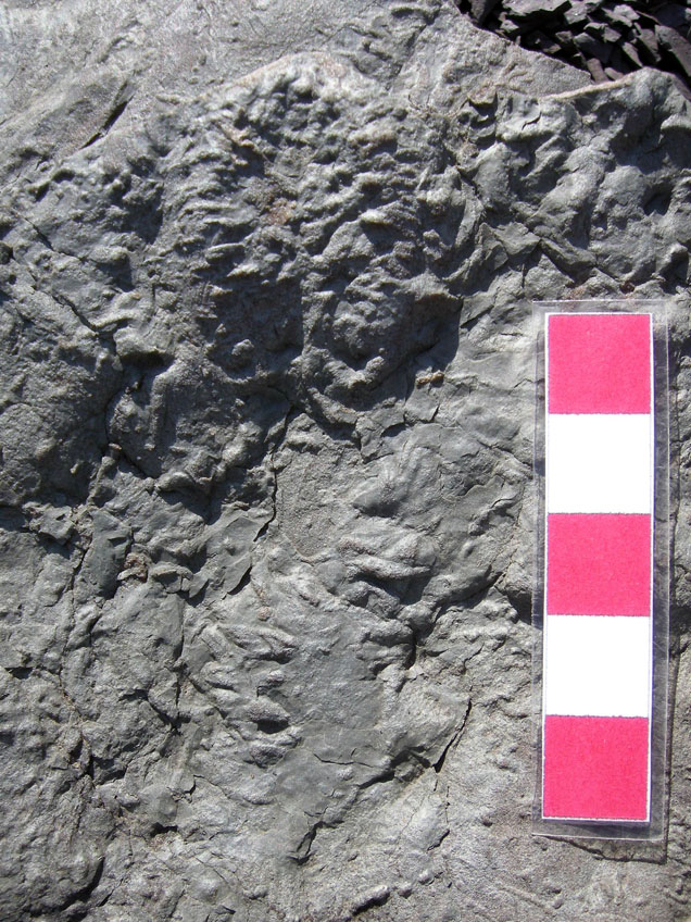
Here’s that trilobite resting trace (Rusophycus) from Georgia that I showed earlier. Now take a gander at the one below…
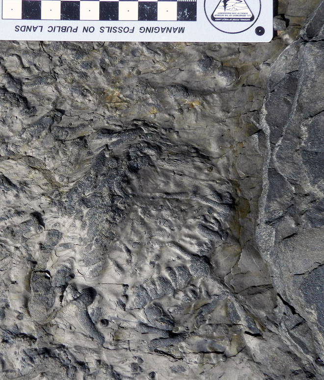
Why, that seems to be a trilobite resting trace (Rusophycus), too, but in Lower Ordovician rocks of Newfoundland. Surprise, surprise, surprise! Scale in centimeters. (Photograph by Anthony Martin.)

Suddenly, much of Andy’s and my previous experience with the Ordovician rocks of Georgia came back to us. We were, paradoxically, home, only in this instance, “home” was a time, not a place. Ichnological colleagues who had no idea Andy and I had worked with Ordovician trace fossils stared at us quizzically (and skeptically) as we excitedly discussed the burrows. But once we informed them that we had seen these trace fossils before, our experience was recognized, egos were set aside, and learning was enhanced. Funny how that works sometimes.

So with our trip to Newfoundland, we went from the alien world of the Ediacaran Period, with its trace fossils unlike anything I had seen before, to the more familiar and accommodating Ordovician Period rocks and their trace fossils. What I learned from this trip, combined with many others to Ordovician rocks elsewhere, as well as the modern sediments of the Georgia coast, was that the mirror was not so foggy after all, and that more field experiences can only further clarify these connections between life traces from the present and the not-so-distant past.

Further Reading

Buatois, L.A., Gingras, M.K., MacEachern, J., Mángano, M.G., Zonneveld, J.-P, Pemberton, S.G., Netto, R.G., and Martin, A.J. 2005. Colonization of brackish-water systems through time: Evidence from the trace-fossil record. Palaios, 20: 321-347.

Eldredge, N., 1970. Observations on burrowing behavior in Limulus polyphemus (Chelicerata, Merostomata), with implications on the functional anatomy of trilobites. American Museum Novitates, 2436: 17 p.

Fillion, D. and Pickerill, R.K. 1990. Ichnology of the Lower Ordovician Bell Island and Wabana Groups of eastern Newfoundland. Palaeontographica Canadiana, 7: 1-119.

Martin, A.J. 1993. Semiquantitative and statistical analysis of bioturbate textures, sequatchie formation (upper ordovician), Georgia and Tennessee, USA. Ichnos, 2: 117-136.

Seilacher, A. 2007. Trace Fossil Analysis. Springer, Berlin: 240 p.

Mistaken Point and the Limits of Actualism

Sometimes we paleontologists, especially those who also study modern organisms and their behaviors, get a little too sure of ourselves, thinking we have a clear vision of life during the pre-human past. So it’s good to have that confidence shaken a little, made uneasy by a glimpse at a much deeper past, one that preceded the bulk of fossils that shape our accepted norms and basic expectations in paleontology.

Welcome to the Ediacaran Period, the span of earth history from 635-542 million years ago, and a time when actualism – the precept that the present is the key to the past – becomes a naïve, idealistic dream, a glib summary of a world that has only existed for a mere 12% of earth history.

What are these? They’re fossils, but otherwise I’m not sure what else to tell you: guess I’ve been spending too much time in the present. But for for those people who have studied them and know better than me, they’re called Charniodiscus, and they’re frond-like fossils with holdfasts (those circular parts connected to their stems) that kept them attached to the seafloor about 565 million years ago. All you have to do to see these fossils is go to Newfoundland, Mistaken Point Ecological Reserve in Newfoundland, Canada, get permission from the Reserve to visit them, have a guide accompany you, and walk 40-45 minutes to the site from a car park. Incidentally, there will be absolutely no cafes or toilets on the way there. You know, just like how it was in the Precambrian. (Photograph by Anthony Martin; scale in centimeters.)

These discomforting realizations started a little less than two weeks ago, inspired by a field trip to the Ediacaran-Cambrian rocks of eastern Newfoundland, Canada. Why was I in cool, temperate Newfoundland, instead of sweating it out on the summertime Georgia coast? The occasion was a pre-meeting trip associated with the International Congress on Ichnology, simply known among ichnologists as Ichnia. This was the third such meeting, a once-every-four-years event (coinciding with years of the summer Olympics). The previous two were in Krakow, Poland (2008) and Trelew, Argentina (2004), and thus far these meetings also include fabulous field trips.

For Ichnia 2012, upon seeing an announcement of a field trip to Mistaken Point and other localities associated with the Precambrian-Cambrian boundary, I eagerly signed up for it. You see, Mistaken Point is world famous for its extraordinary preservation of more than 1,000 body fossils of those weird and wonderful fossils known as the Ediacaran fauna, Ediacaran biota, Vendian fauna, or Vendobionts (take your pick). This was the main reason why my fellow ichnologists on the field trip – 16 of us from 9 countries – were along for the ride, despite the trip’s clear emphasis on body fossils.

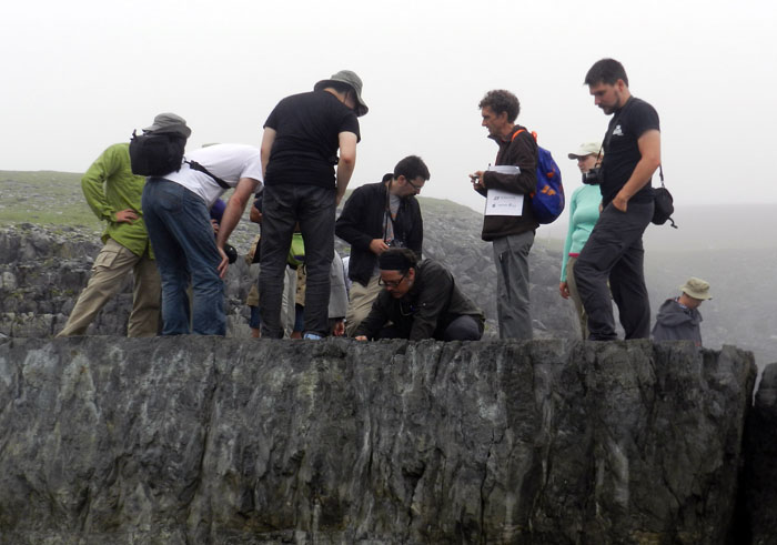
A rare photo of ichnologists getting really excited about seeing body fossils, which is totally understandable when we’re talking about the Ediacaran fossils at Mistaken Point, Newfoundland. Eventually, though, they later became unruly and started demanding, “Show me your trace fossils!” Fortunately for the sake of international ichnological relations, the field-trip leaders happily obliged that same day. (Photograph by Ruth Schowalter.)

These rare fossils, which are strange enough to even cause paleontologists to question whether or not they are animals (hence the cautious use of the more inclusive term “biota” instead of “fauna”), are abundantly exposed on broad bedding planes in Mistaken Point Ecological Reserve on the southeastern coast of Newfoundland. Discovered in 1967, these fossils have since proved to be one of the best examples of easily visible body fossils from more than 542 million years ago, and the Newfoundland fossils comprise the only such assemblage that originally lived in deep-marine environments. They evidently died in place when suffocated by a layer of volcanic ash that settled onto the seafloor, hence the fossils reflect a probable sample of their original ecosystem. This ash layer neatly preserved the fossils, and its minerals provided a means to calculate absolute age dates for the assemblage, which is from 565 +/- 3 mya (million years ago).

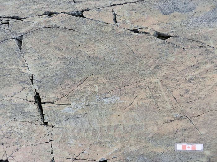
Bedding-plane exposure at Mistaken Point with many frond-like fossils, broadly referred to as rangeomorphs. (Photograph by Anthony Martin, Canadian-themed scale is in centimeters.)

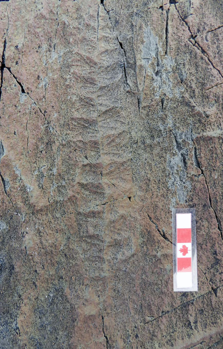
A close-up of one of the more exquisitely preserved rangeomorphs, which I think is Fractofusus misrai. But you really shouldn’t trust this ichnologist with that identification, so it’d be wise to double-check that with a real expert. (Photograph by Anthony Martin.)

Just a few years ago, though, Mistaken Point became paleontologically famous again, and this time for its trace fossils. Researchers from Memorial University in Newfoundland and Oxford University looked at bedding planes near those holding the the body fossils, and were surprised to find a few trails there. At that time, it was the oldest evidence of animal movement from the fossil record, and although these finds have been disputed and others have tried to stake this claim for trace fossils elsewhere, it is still holding up fairly well.

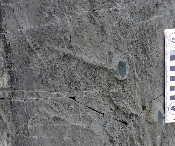
A surface trail, probably made by a < 1 cm wide animal moving along the seafloor about 565 mya. The animal moved from left to right, which is indicated by the crescentic ridges inside the trail, which open in the direction of movement. (Photograph by Anthony Martin, taken at Mistaken Point, Newfoundland.)

Another surface trail, but this one without the internal structure of the other one, and with levees on either side of the central furrow. (Photograph by Anthony Martin, taken at Mistaken Point, Newfoundland.)What’s this? Don’t have a clue. It looks like a series of overlapping trails, some looping, but would have taken me several hours to unravel. Anyway, it generated some good discussion at the outcrop, and they’re probably trace fossils, which made us ichnologists both happy and perplexed. (Photograph by Anthony Martin, taken at Mistaken Point, Newfoundland; scale in centimeters.)

What made these trace fossils? It’s hard to say, and that’s a humbling statement for me to make. In public talks I’ve given about my upcoming book, and in a presentation I gave the following week at Ichnia on the Memorial University campus, I’ve assured how the actualism of the Georgia barrier islands and its traces can reliably serve as models for interpreting many trace fossils formed in different environments, and trace fossils of various geologic ages from around the world. But in this instance, I didn’t have a inkling of what made the Mistaken Point trace fossils. These trace fossils were also made in deep-marine environments, which are lacking from the Georgia coast, and I haven’t learned much about deep-marine trace fossils from elsewhere.

In short, my ignorance was showing, and these trace fossils were completely out of my realm of experience. The only feeble hypothesis I could conjure on the basis of what I’ve seen in modern sediments of the Georgia barrier islands are small marine gastropod trails. Sorry, that’s all I got.

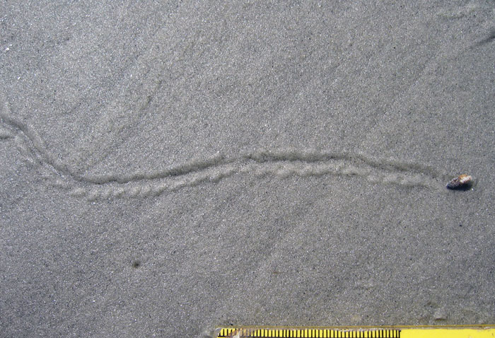
Oooo, look, it’s snail! Making a trail! Isn’t that neat? And if you squint really hard and have a couple of beers, you might agree that it almost resembles one of the fossil trails from Mistaken Point. Don’t see it yet? Here, have another beer. (Photograph by Anthony Martin, taken at Sapelo Island, Georgia; scale in millimeters. )

But if ignorance loves company, I can feel good in knowing that others have grasped at the same straw of actualism and found it far too short. I could tell a few of my ichnological colleagues were likewise a little challenged by what they saw at Mistaken Point, and I knew that for some of them – like me – they normally deal with trace fossils in much younger rocks. But hey, that’s what geology field trips are supposed to do: challenge us with what’s really there in the rock record, right there in front of us, rather than what we wish were there.

Fortunately, a little more information provided during the meeting after the field trip helped my understanding of the trace fossils we saw at Mistaken Point, and actually connected to modern tracemakers. Alexander Liu, the primary author of the paper that first reported the trace fossils, gave a talk that reviewed the evidence for Precambrian trace fossils, including those from Mistaken Point. In experiments he and his coauthors did with living anemones in a laboratory setting, they were able to reproduce trails similar to the Mistaken Point trace fossil with the internal structure. Thus these researchers were able to use actualism to assist in their interpretation, which also meant that neoichnology was not so useless after all when applied to the Ediacaran. That made me feel a little better.

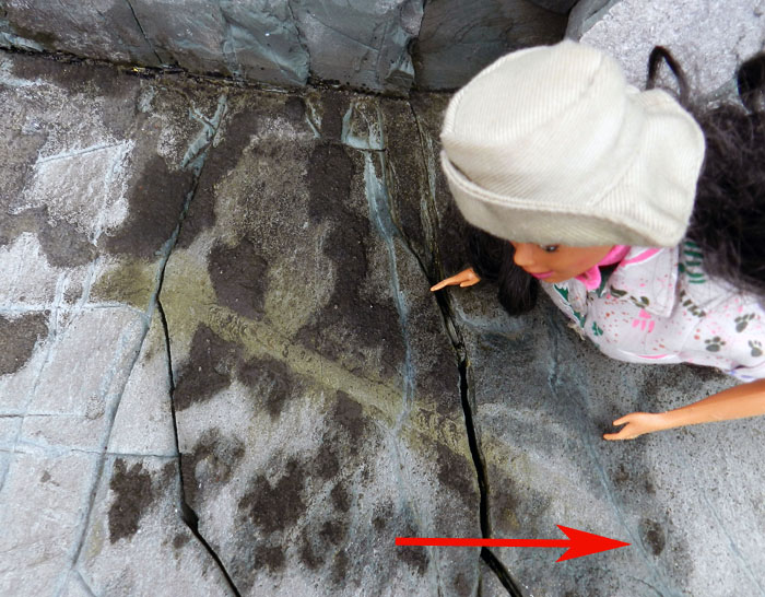
Let’s take a look at that first surface trail again, but this time with the help of my trustworthy colleague Paleontologist Barbie, who was along for the field trip. The crecentic ridges in the interior of the trail may represent marks where the basal disc of a anemone-like animal pushed against the surface as it moved. Even more interesting, the arrow points to an oval impression, which may be a resting trace that shows the approximate basal diameter of the tracemaker. What was the tracemaker? It’s currently identified as a small anemone, which is based on modern traces. Neoichnology rules! (Photograph by Anthony Martin.)

Ediacaran trace fossils still engender debate, though, and especially with people who don’t necessarily accept that animals made trails during the Ediacaran. For instance, about four years ago, some scuba-diving researchers observed a giant protozoan making a trail on a sediment surface in the Bahamas. Accordingly, they proposed that one-celled organisms – not animals – could have made similar trails during the Ediacaran Period. Interestingly, this shows how actualism can produce conflicting results when applied to Ediacaran fossils. After all, it’s still a big world out there, and we humans haven’t really observed everything in it yet.

So I’ll make one last point about Ediacaran fossils here, then will move on to more recent times. If you think that at the very least we paleontologists should be able to tell the difference between trace fossils and body fossils in Ediacaran rocks, you’re also in for some confusion. In the only research article I have ever attempted on Ediacaran fossils, which were much closer to Georgia – coming from the Carolina Slate Belt of North Carolina – my coauthors and I struggled with exactly that question with some fossils found in that area. In the end, we said they were body fossils, not trace fossils. And as everyone knows, I love trace fossils, and I really wanted these to be trace fossils. But they were not. That’s science for you: denying your deepest desires in the face of reality.

So surely the Cambrian would be easier to interpret, right? I meanl, after 542 mya, animals started burrowing merrily, to and fro, hither and tither, with uninhibited and orgiastic abandon, and, well, you get the idea. But, not really. Another part of the field trip involved looking at what happened with the departure of the relatively unbioturbated alien world of the Ediacaran, pre-542 mya, to the more familiar sediment mixing of the Cambrian and Ordovician Periods, post-542 mya. Yet even these rocks and their trace fossils were still not quite like what we see today.

This will be the subject of my next post, which will again explore the theme of how we should approach strict actualism like any scientifically based idea: with a mixture of astonished wonder, but also with a hard-edged look at what is really there.

As we bid adieu to Mistaken Point and began our walk back to the car park, we could swear we saw lifeforms emerging from the mist-covered rocks, resurrected from the deep time and deep water of the Avalonian Precambrian. Then we realized those were just some of our group behind us. Oh well. Maybe next time. (Photograph by Anthony Martin.)

(Acknowledgements: Much appreciation is extended to the field trip leaders – Liam Herringshaw, Jack Matthews, and Duncan McIlroy – for their organization and execution of a fantastic three-day field trip; to Valerie and Richard of the Mistaken Point Ecological Reserve for guiding us to the site; to my ichnological colleagues for their cheery and knowledge-broadening company; and my wife Ruth for being with me and providing an artist’s perspective about her experiences with us crazy ichnologists, shared here and here.)

Further Reading

Fedonkin, M., Vickers-Rich, P. Grey, K., and Narbonne, G. 2007.The Rise of Animals: Evolution and Diversification of the Animalia. Johns Hopkins Press, Washington: 320 p.
Liu, A.G., McIlroy, D., and Brasier, M.D. 2010. First evidence for locomotion in the Ediacaran biota from the 565Ma Mistaken Point Formation, Newfoundland. Geology, 38: 123-126.

Matz, M.V., Frank. T.M., Marshall, N.J., Widder, E.A., and Johnsen, S. 2008. Giant deep-sea protest produces bilaterian-like traces. Current Biology, 18: 1-6

Tacker, R.C., Martin, A.J., Weaver, P.G., and Lawver, D.R. 2010. Trace vs. body fossil: Oldhamia recta revisited. Precambrian Research, 178: 43-50.

Vickers-Rich, P., and Komarower, P. (editors). 2007 The Rise and Fall of the Ediacaran Biota. Geological Society of London, Special Publication 286: 448 p.
Traces of Toad Toiletry and Naming Trace Fossils

Sometimes I envy those people on the Georgia barrier islands who, through sheer number of hours in the field, come upon animal traces that I’ve never seen there. But this was one of those instances where the find was so extraordinary that I will suppress my jealous urges, celebrate the person who found it, marvel at it, and share its specialness with others.

Gale Bishop, a fellow ichnologist who is currently on St. Catherines Island, found an intriguing sequence of traces during a morning foray on its dunes and beaches there last week. In his second life – his first was as a geology professor at Georgia Southern University – he has transformed into an indefatigable sea-turtle-nesting monitor on St. Catherines and coordinator of a teacher-training program. Part of his daily routine there, among many other duties, includes looking for mother-turtle traces – trackways and nests – during the nesting season, which in Georgia is from May through September.

Along the way, with his eyes well trained for spotting jots and tittles in the sand, Gale often notices oddities that likely would be missed by most people, including me. The following photograph, which he shared on the St. Catherines Island Sea Turtle Program page on Facebook, is from a find he made about 7:15 a.m. on Saturday, July 7. Take a look, and please, if you haven’t already, forget the title of this post as you ponder its clues.

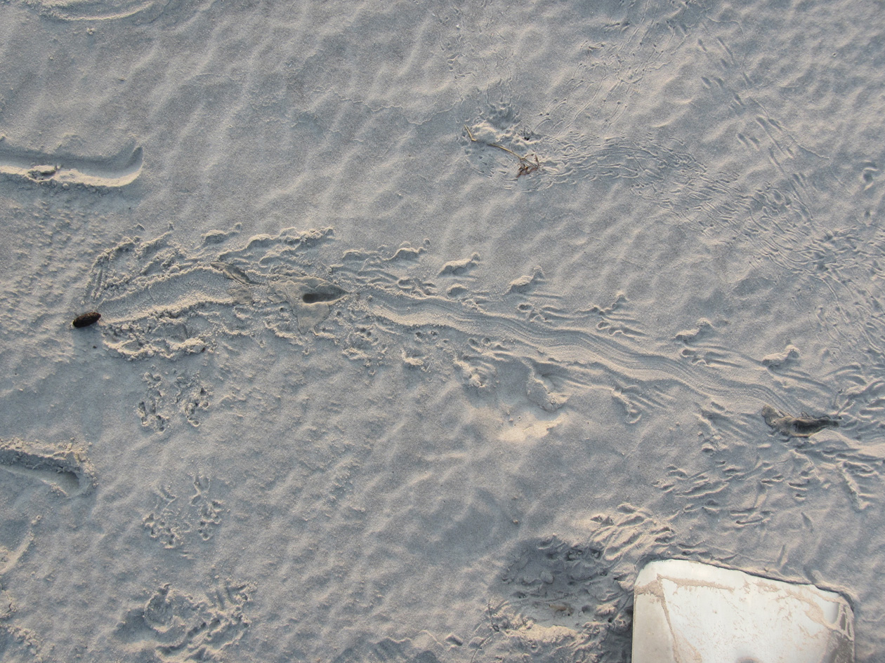
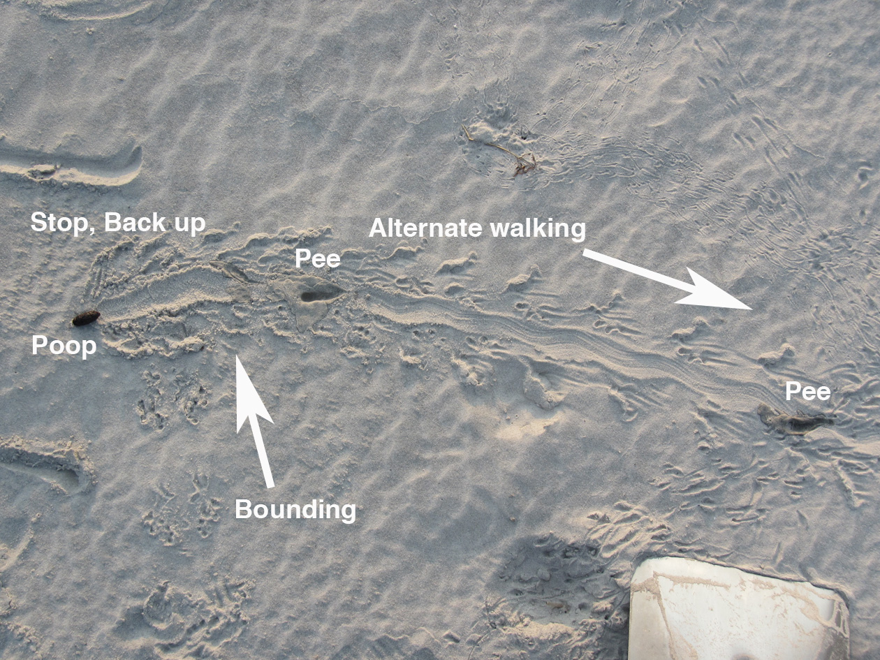
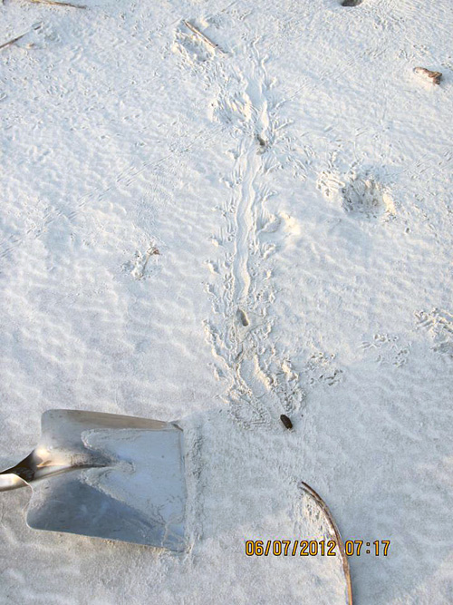
A mystery in the dune sands of St. Catherines Island on the Georgia coast, begging to be interpreted. No, not the shovel: those are never mysterious. Look at the traces to the left and above the shovel. What made these, what was it doing, and who else was in the neighborhood afterwards? Oh, and again, stop staring at the shovel. (Photograph by Gale Bishop.)

Gale called me out specifically when he posted this and several other related photos on Facebook, and asked me to tell a story about it. I gave him my abbreviated take in the comments, kind of like an abstract for the research article:

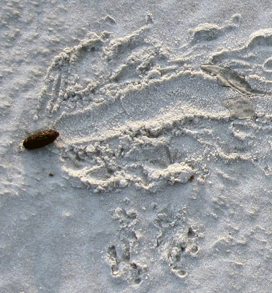
Looks like southern toad (Bufo terrestris) to me. What’s cool is the changes of behavior: hopping, stopping, pooping, and alternate walking (which people don’t expect toads to do – but they do).

That was my knee-jerk analysis, which took a grand total of about a minute to discern and respond. (After all, this was Facebook, a forum in which prolonged and deep thinking is strongly discouraged.) But I also kept in mind that quick, intuitive interpretations later need introspection and self-skepticism, especially when I’m making them. (See my previous post for an example of how wrong I could be about some Georgia-coast traces.) So rather than fulfill some Malcolm Gladwell-inspired cliché through my intuition, I sat down to study the photo with this series of questions in mind:

  • Why did I say “Southern toad” as the tracemaker for the sequence of traces that start from the lower left and extend across the photo?
  • What indicates the behaviors listed and in that order: hopping, stopping, pooping, and alternate walking?
  • What signified the changes in behavior, and where did these decisions happen?
  • Why did I assume that most people don’t expect toads to walk (implying that they think they just hop)?

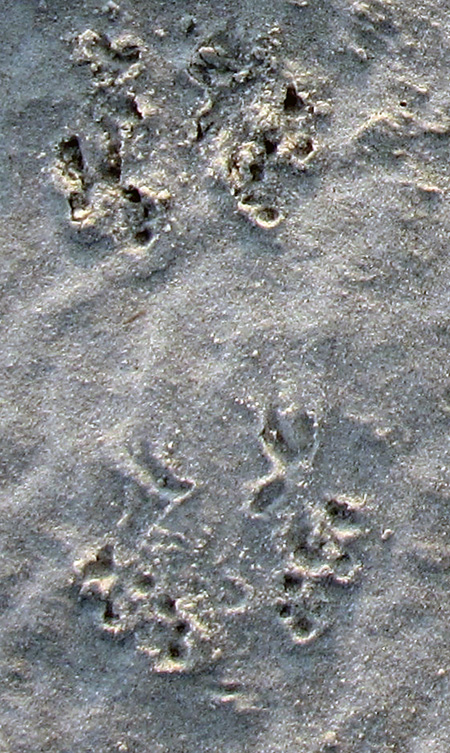
The first leap in logic – how did I know a Southern toad (Bufo (Anaxyrus) terrestris) was the tracemaker – was the easiest to make, as I’ve often seen their tracks in sandy patches of maritime forests and coastal dunes. These hardy amphibians leave a distinctive bounding pattern, with the front-foot impressions together and just preceding the rear-foot ones; the toes of their front feet also point inward. In the best-expressed tracks, you will see four toes on the front feet and five toes on the rear.

Close-up of bounding pattern (from lower left of previous photo), showing front-foot impressions just in front of and more central than the rear feet impressions. Direction of movement is from bottom to top of photo. (Photograph enhanced to bring out details, but originally taken by Gale Bishop.)

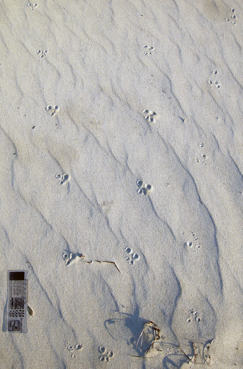
The only other possible animal that could make a trackway pattern confusable with a toad in this environment is a southeastern beach mouse (Peromyscus polionotus). Still, mice mostly gallop, in which their rear feet exceed their front feet as they move. Mouse feet are also very different from those of a toad, with toes on both feet all pointing forward (remember, toad toes point inward). So although dune mice live in the same environment as these tracks, these weren’t mouse tracks. The only alternative tracemakers would be spadefoot toads (Scaphiopus holbrookii) or a same-sized species of frog, such as the Southern leopard frog (Rana sphenocephala). But neither of these species is as common in coastal dunes as the Southern toad, so I’ll stick with my identification for now.

Mouse tracks – probably made by the Southeastern beach mouse (Peromyscus polionotus) – on costal dunes of Little St. Simons Island, Georgia. The two trackways on the left are moving away from you, whereas the one on the trackway on the right is heading toward you. All three show a gallop pattern, in which the larger rear feet exceeded the front feet. Scale = 10 cm (4 in). (Photograph by Anthony Martin)

The second conclusion – the types of behaviors and their order – came from first figuring out the direction of travel by the tracemaker, which from the lower left of the photo toward its middle. This shows straight-forward hopping up to the point where it stops.

From there, it gets really interesting. The wide groove extends to the left past the line of travel and had to be made by the posterior-ventral part of the toad’s body (colloquially speaking, its butt). This, along with the disturbed sand on either side of the groove, shows that the toad turned to its right (clockwise) and backed up with shuffling movement. That’s when it deposited its scat, which I’ve also seen in connection with toad tracks (and on St. Catherines, no less). This really helped me to nail down the identity of the tracemaker, almost being able to declare, “Hey, I know that turd!”

Southern toad bounding pattern that abruptly stops, followed by clockwise turning, backing up, and, well, making a deposit. (Photograph by Gale Bishop, taken on St. Catherines Island.)

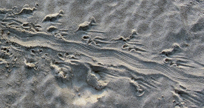
How about the alternate walking? Turns out that toads don’t just hop, but also walk: right side, left side, right side, and so on. This pattern – also called diagonal walking by trackers – is in the remainder of the photo (with the direction of movement left to right). When toads do this, the details of their front and rear feet are better defined, and you can more clearly see the front foot registers in front of the rear and more toward the center line of the body.

This side-by-side movement is also what imparted a slight sinuosity to the central body dragmark, which was from the lower (ventral) part of its body, or what some people would call “belly.” In my experience, most people are very surprised to find out that toads can walk like this, which I can only attribute to sample bias. In other words, they’ve only seen frogs and toads hop away from them when startled by the approach of large, upright bipeds.

Close-up of alternate walking pattern and body dragmark made by Southern toad. Direction of movement is from upper left to lower right. (Photograph enhanced to bring out its details, but original taken by Gale Bishop on St. Catherines Island.)

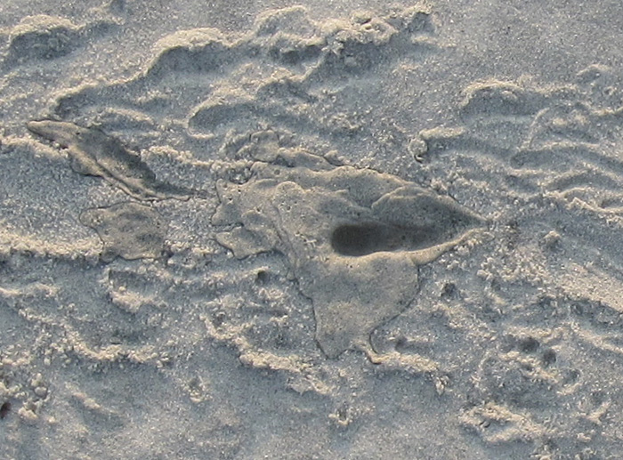
But wait, what are those two dark-colored depressions in the center of the alternate-walking trackway? Well, it doesn’t take much imagination to figure those out, especially if you’ve already had a couple of cups of coffee. Yes, these are urination marks, and even more remarkable, there are two of them in the same trackway. So not only did this toad do #2, but also #1 twice.

Southern toad urination mark #1, not too long after doing #2. (Photograph by Gale Bishop.)

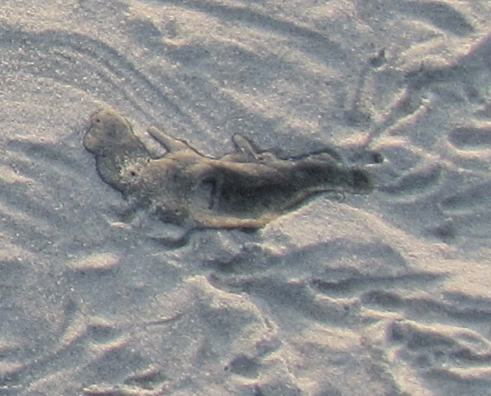
Urination mark #2 , which you might say was #2 of #1, but with both #1’s after #2, or, oh, never mind.

Notice that the second mark seems to have had less of a stream to it, which makes sense in a way that I hope doesn’t require any more explanation or demonstration.

So to answer to one of the questions above – what signified the changes in behavior – you have to look for the interruptions in the patterns, much like punctuation marks in a sentence. The commas, semi-colons, colons, dashes are all part of a story too, not just the words.

The summary interpretation of what happened. Let’s just say that this frog (or toad, whatever) didn’t come a courtin’.

Through the series of photos Gale shared in an album on Facebook, he also showed that he was following a protocol all good trackers do: he changed his perspective while observing the traces. Likewise, I teach my students to use this same technique when presented with tracks and other traces, that it’s a good idea to walk around them. While doing this, they see changes in contrast and realize how the direction and angle of light on the traces alters their perceptions of it. At some points, a track or other trace may even “disappear,” then “reappear” with maximum clarity with just a few more steps.

A different perspective of the same traces, viewed from another angle. Do you notice something new you didn’t see in the previous photo and its close-ups? (Photograph by Gale Bishop, taken on St. Catherines Island.)

Now, because I’m also a paleontologist, this interesting series of traces also prompts me to ask: what if you found this sequence of traces in the fossil record? Well, it’d be a fantastic find, worthy of a cover story in Nature. (That is, if the tracks somehow went across the body of a feathered dinosaur.) Right now, I can’t think of any trace fossils like this coming from vertebrates – let alone toads or frogs – so let’s go to invertebrate trace fossils for a few examples of similarly interconnected behaviors preserved in stone.

In 2001, a sequence of trace fossils was reported from Pennsylvanian Period rocks (>300 million years old), in which a clam stopped, fed, and burrowed along a definite path, with all of its behaviors clearly represented and connected. The ichnologists who studied this series of trace fossils – Tony Ekdale and Richard Bromley – reckoned these behaviors all happened in less than 24 hours; hence the title of their paper reflected this conclusion.

Ichnologists have a sometimes-annoying and always-confusing practice of naming distinctive trace fossils, giving them ichnogenus and ichnospecies names. (For a detailed discussion of this naming method, I talked about it in another blog from the dim, dark, distant past of 2011 here.) For instance, Ekdale and Bromley stated in their study that three names could be applied to the distinctive trace fossils made by a single clam, with each a different form made by a different behavior: Protovirgularia (burrowing), Lockeia (stopping), and Lophoctenium (feeding).

Along those lines, another ichnologist (Andy Rindsberg) and I also suggested that an assemblage of trace fossils in Early Silurian rocks (>400 million years old) of Alabama, with many different ichnogenera, were all made by the same species of trilobite. The take-home message of that study, as well as Ekdale and Bromley’s, is that a single species or individual animal can make a large number of traces. This also means that ichnodiversity (variety of traces) almost never equals biodiversity (variety of tracemakers).

So let’s go back to the toad traces, put on our paleontologist hats, and think about a “what if.” What if you found this series of traces disconnected from one another: the hopping trackway pattern, the diagonal walking pattern, the urination marks, the groove, and the turd, all found in disparate pieces of rock? Taken separately, such trace fossils likely would be assigned different names, such as “Bufoichnus parallelis,” “B. alternata,” “Groovyichnus,” “Tinklichnus,” and “Poopichnus.” (Please do not use these names beyond an informal, jovial, and understandably alcohol-fueled setting.)

Color, present-day version of the variety of traces made by a Southern toad (above), and a grayscale imagining of it fossilizing perfectly (below). Key for whimsically named ichnogenera in fossilized version: Bp = “Bufoichnus parallelis,” Ba = “Buofichnus alternata,” G = “Groovyichnus,” P = “Poopichnus,” and T = “Tinklichnus.” Please don’t cite this.

Granted, the environment in which Gale noted these traces – coastal dune sands – are not all that good for preserving what is pictured here, but other environments might be conducive to fossilization. To quote comedian Judy Tenuta, “It could happen!”

So if someone does find a fossil analogue to Gale’s evocative find on St. Catherines Island, I will understand their giving a name to each separate part, even if I won’t like it. The most important matter, though, is not what you call it, but what it is. And in this case, the intriguing story of toiletry habits left in the sand one July morning by a Southern toad is worth much more than any number of names.

Further Reading

Ekdale, A.A., and Bromley, R.G. 2001. A day and a night in the life of a cleft-foot clam: Protovirgularia-Lockeia-Lophoctenium. Lethaia, 34: 119–124.

Halfpenny, J.C., and Bruchac, J. 2002. Scats and Tracks of the Southeast. Globe Pequot Press, Guilford, Connecticut: 149 p.
Jensen, J.B. 2008. Southern toad. In Jensen, J.B., Camp, C.D., Gibbons, W., and Elliott, M.J. (editors), Amphibians and Reptiles of Georgia. University of Georgia Press, Athens, Georgia: 44-46.
Rindsberg, A.K., and Martin, A.J. 2003. Arthrophycus and the problem of compound trace fossils. Palaeogeography, Palaeoclimatology, Palaeoecology, 192: 187-219.

Life Traces as Cover Art

I’ve been a long-time admirer of the artistic appeal of tracks, trails, burrows, nests, and other traces of animal behavior. My fondness for the beauty of traces also no doubt contributes to my science: after all, the longer I look at a trace, the more I learn about it. This sentiment accords with a long-time principle of paleontology, botany, and other facets of natural history, which is, “If you draw it, you know it,” with the added benefit of expressing your appreciation of natural objects to others through visual depictions.

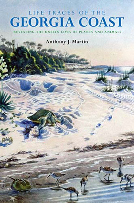
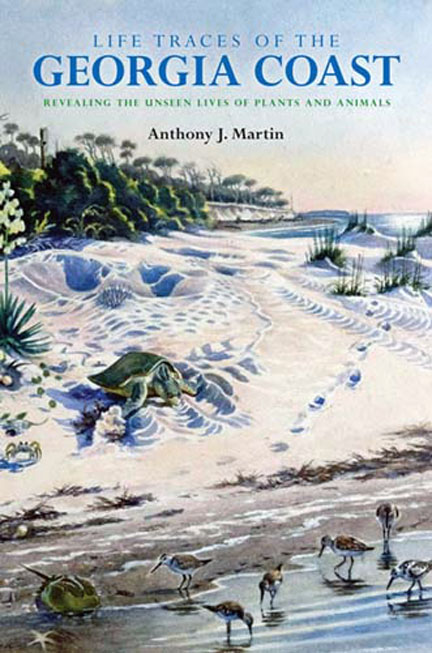
Here it is: the cover for my upcoming book, Life Traces of the Georgia Coast: Revealing the Unseen Lives of Plants and Animals! The book is scheduled to be published by Indiana University Press in the fall of 2012, so be watching out for it then. But in the meantime, look at the beautiful cover art. Who created it, what inspired it, and what science lies behind its aesthetically pleasing composition? Please read on to find out.

My thinking about traces as objects of art is not very original, though, and in fact has been preceded by most of humanity. For example, animal tracks and other traces were common subjects of rock art extending back to the Pleistocene Epoch. Whether made as pictographs or petroglyphs, these traces of traces are in Australia, southern Africa, Australia, and Europe, with some tens of thousands of years old. Based on this tantalizing evidence, one could reasonably propose that the representation of animal traces through art composes an intrinsic part of our heritage as a species. Yes, I know, that’s a tough hypothesis to pursue any further. So I’ll leave it to my paleoanthropologist colleagues to work out (or not).

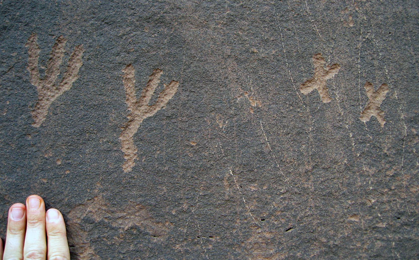
Petroglyphs that likely represent bird tracks, etched in Triassic sandstone by Native Americans hundreds of years ago (sorry, I’m a paleontologist, not an archaeologist). The pair of marks on the right is similar to the tracks made by a perching bird with three forward pointing toes and one rearward-pointing toe – such as an eagle – whereas those to the right may be like those of a roadrunner, which has an X-shaped foot. Petroglyphs are in northeastern Arizona, near Petrified Forest National Park.

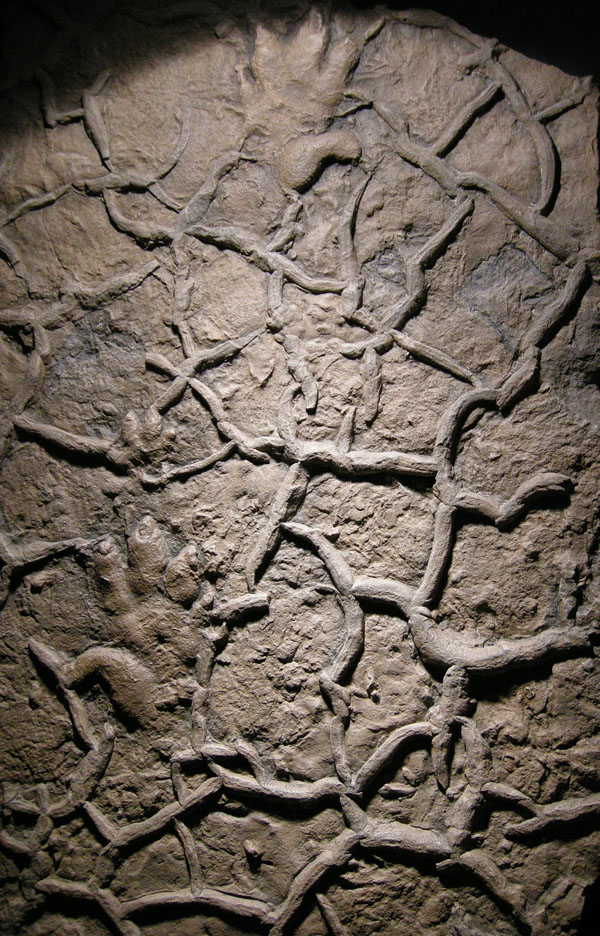
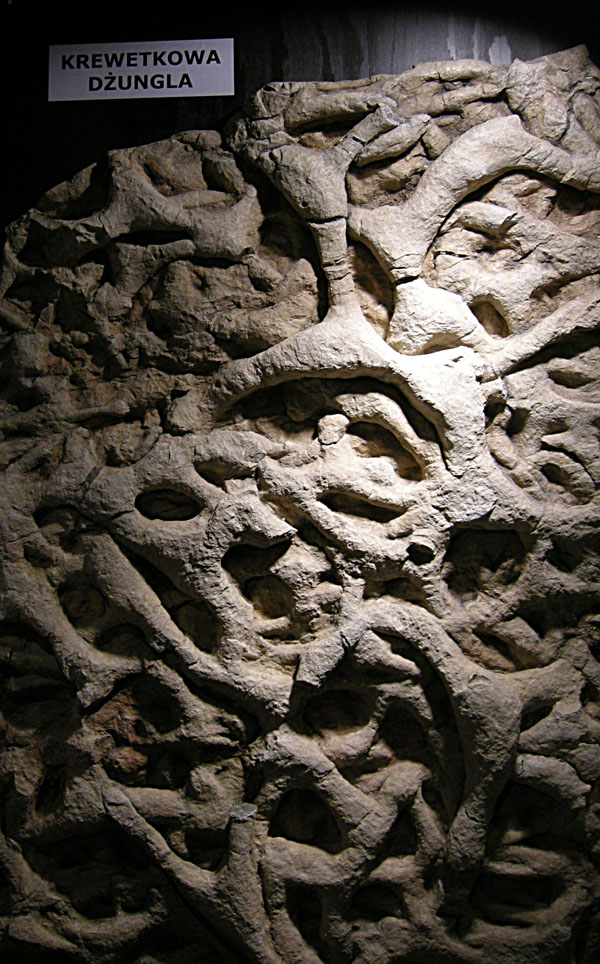
Much more recently, trace fossils similarly inspired renowned ichnologist Dolf Seilacher, who also saw these vestiges of past behavior as lovely objects that fill us with wonder. As a result, in the mid-1990s, he conceived of a traveling exhibit and book showcasing tableaus of trace fossils and other sedimentary structures, titled Fossil Art. For this show – embraced by natural-history venues but mostly rejected by art museums – Seilacher prepared it by: (1) making latex molds of sedimentary rock surfaces; (2) pouring epoxy resin into the molds to make casts mimicking the original bedding planes; and (3) using indirect lighting to enhance details; and (4) assigning creative titles to each piece as if they were works of art.

So these artificial slabs are not human-made art in the traditional sense, but nonetheless invoke marvel, project splendor, and otherwise make us think, engaging the same senses and thought processes that accompany an appreciation of art. Moreover, the slim book Seilacher authored for the exhibit contains explanatory text about each of the objects, illuminated further by his marvelous illustrations and visual interpretations. I remember first seeing a version of this exhibit in Holzmaden, Germany in 1995, near Seilacher’s home in Tubingen, and most lately enjoyed strolling through it with other many ichnologists – and Seilacher himself – in Krakow, Poland in 2008.

World-renowned ichnologist and (oh yeah) Crafoord Prize winner, Dolf Seilacher, lecturing about the planning and execution of Fossil Art as an exhibit while it was showing at the Geological Museum of Jagiellonian University in Krakow, Poland in September 2008. Photograph by Anthony Martin.

A close-up of Wrong Sided Hands, one of the pieces displayed in Fossil Art, cast from a latex mold of a sample from Lower Triassic Buntsandstein of Germany. The piece is so-called because the false appearance of a “thumb” on the outside of the tracks originally led to the mistaken idea that the animal awkwardly crossed its own path with each step. This turned out to be wrong. Also, check out the mudcracks! Photograph by Anthony Martin.

Another close-up of a piece from Fossil Art, titled Shrimp Burrow Jungle (helpfully translated into Polish here). This one is based on burrow systems made by crustaceans during the Late Triassic in Italy, which became densely populated over time and hence contributed to overlapping systems. Photograph by Anthony Martin.

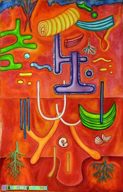
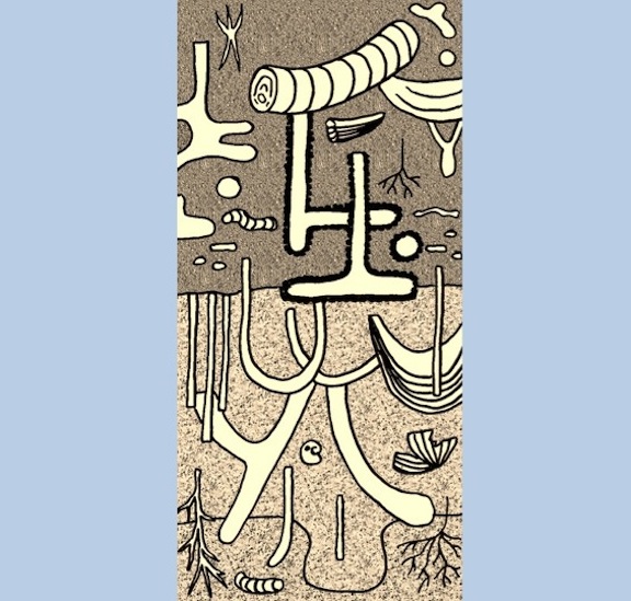
Hence during my writing of a book about the modern traces of the Georgia barrier islands, I was well aware of how some of these traces could likewise lend to artistic expression. Some of this mindfulness was applied to a collaborative artwork done with my wife, Ruth Schowalter, in which we took an illustration of mine from the book and used it as the inspiration for a large watercolor painting depicting traces that would form with rising sea level along the Georgia coast (discussed in detail here).

Nonetheless, it was especially important to think about traces as art when considering a potential cover for the book. Book authors know all too well that a well-designed, attractive cover is essential for grabbing the attention of a potential reader, so I had that practical consideration in mind. But I also wanted a cover that pleased me personally, sharing my love of beautiful traces with others, especially those varied and wondrous tracks, burrows, and trails I had seen and studied on the Georgia barrier islands during the past 15 years.

In such an endeavor, I also faced the added pressure of precedence set by my publisher, Indiana University Press. My book is part of a series by IU Press, called Life of the Past, which is widely admired not only for its comprehensive coverage of paleontological topics, but also for its fine cover art, showcasing works done by a veritable “who’s who” of “paleoartists,” So I knew the cover art for my book needed to both conform to this legacy of artistic excellence, but also stand out from other books in the series because of its unique themes. After all, this would be first book in Life of the Past focusing specifically on ichnology. Moreover, the book is more concerned on modern tracemakers and their environments, rather than plants and animals of pre-human worlds. This was done with the intention of demonstrating how our knowledge of modern traces helps us to better understand life from the geologic past, an intrinsic principle of geology called uniformitarianism.

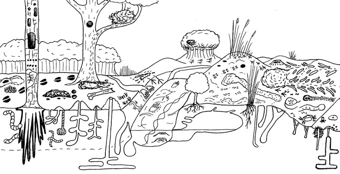
Ideally, as an ichnological purist, I would have had a cover devoid of any animals, and just shown environments of the Georgia of the Georgia coast with their traces. Indeed, I did just that in some of my illustrations in the book, in which I purposefully omitted animals and left only their traces. This “ichno-centric” mindset actually serves a pedagogical purpose, in that it would echo the truism that many sedimentary rocks are devoid of body fossils, yet are teeming with trace fossils.

Figure 1.3 from Life Traces of the Georgia Coast, conveying a sense of the variety and abundance of traces on a typical Georgia barrier island, from maritime forest (left) to shallow intertidal (right). I purposefully drew this illustration using a more cartoonish technique to introduce broad search images of traces for people who may not ordinarily think about these. But also notice what’s missing from the figure: the animal tracemakers. Instead, only immobile plants are depicted. Would this make for good cover art? No and no, especially if you’ve seen the typical covers done for Indiana University Press books. Illustration by Anthony Martin.

Realistically, though, I also knew that modern traces, particularly those made in places as easy to visit as parts of the Georgia coast, would be more eye-catching if accompanied by some of their charismatic tracemakers in a beautiful, natural setting. After all, the Georgia coast has lengthy sandy beaches, dunes, maritime forests, and salt marshes, inhabited by a wide variety of animals, such as sea turtles, shorebirds, alligators, horseshoe crabs, ghost crabs, and many others.

I also knew that a paleoartist would not be as well suited to the task of creating a cover as someone who works more with modern environments. A better pick would be someone who was familiar with the landscapes, plants, and animals of the Georgia barrier islands, but also a fine artist. I briefly toyed with the idea of doing it myself, but already felt like far too much of the book had been “DIY,” and was not confident enough in my skills to put together a compelling cover in enough time before the book came together. An artfully done photograph was another possibility, so I sent several prospective examples to the editors for their appraisal, but these were all shot down for not having enough aesthetic elements for an attention-getting cover (i.e., traces + landscapes + sky + water = very difficult to get into a single photo).

Fortunately, through social connections that still happen despite the Internet and its incentives for becoming increasingly introverted, I met Alan Campbell through mutual friends in December 2008 at a dinner party on the Georgia coast. Fortuitously enough, our meeting was also just before Ruth and I did three weeks of field work on the barrier islands for the book. It was only fitting, then, that our first meeting was spent dining with both of us facing a Georgia salt marsh, filled with fiddler crab burrows and other such traces. Alan is a Georgia artist with much life experience along its coast, he has often portrayed its environments through gorgeous watercolors, and he has worked with scientists in the field.

Consequently, I kept Alan in mind as a potential cover artist for the next few years, and after I had finished the text and all figures for the book, I contacted him last year about my idea, while simultaneously suggesting him to the editors at IU Press. After much back-and-forth negotiations, with me in the middle, both parties finally came to an agreement, and Alan had a contract to do the artwork for the cover by December 2011.

To help Alan in researching his task, I sent him all of my illustrations and photos used in the book so that he would have an extensive library of trace images on hand for reference. He also had this blog as a source, in which I regularly write about Georgia-coast traces, explanations that are always accompanied by photographs and an occasional illustration. We also exchanged many e-mails and talked on the phone whenever needed. I told Alan my preferred cover would feature a coastal scene, but one filled with traces. He voiced a concern that the painting might become too “busy,” and the details might be lost in reduction of the image to the size

Alan’s contract specified that he would have preliminary study sketches would be done by February 1, and the final cover art was to be finished by March 30. He was only a little late with the study sketches (delayed by a minor operation), and I was delighted to see the following sketch in mid-February.

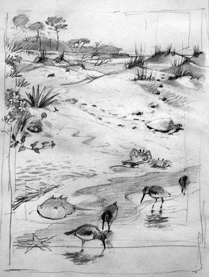
Study sketch by Alan Campbell for the cover of Life Traces of the Georgia Coast. Reprinted with his permission, and anyone else who want to use it, you have to ask him, too. By the way, every time you use original artwork without permission, a little kitten dies.

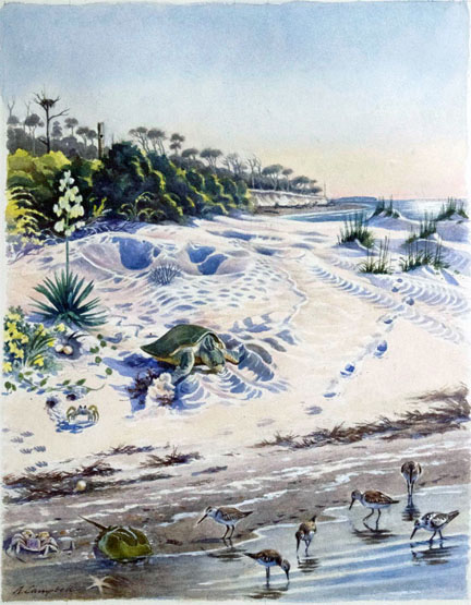
After a little bit of feedback from both me and graphic designers at IU Press, Alan went back to the drawing board (so to speak), and came up with the following watercolor painting.

Life Traces of the Georgia Coast, 2012, watercolor on paper, 14” X 18” by Alan Campbell. Again, if you want to use it, you have to ask him first and get permission. Remember those kittens? They’re alive now, but there’s no guarantee they’re going to stay that way.

I gave this artwork a big thumbs up, as did the people at IU Press. So once approved and the scan was sent to IU Press, it was up to the graphic designers there to pick out the typeface, color of the type for the main title, subtitle, author name, and placement of type without covering up the main composition of the painting. I had no say in this, and that’s a good thing, because they really knew what they were doing. It is a very nicely designed cover, and the only thing that would please me more is if they had produced a holographic image of it. (Maybe next year.)

The final cover art for Life Traces of the Georgia Coast revisited. Does it look a little different, now that you know more about how it came about?

I won’t spoil the fun for potential readers, scientists, and art appreciators by explaining in detail all of the ichnological, ecological, and geological elements incorporated into the cover. After all, I’d like to sell a few copies of the book, while also letting readers make their own personal discoveries. But hopefully all of you now have a better appreciation for how traces made by animals, our recognition and admiration for these, and artistic expression of them can all combine to contribute to a book that can be accurately judged by its cover.

Further Reading

Leigh, J., Kilgo, J., and Campbell, A. 2004. Ossabaw: Evocations of an Island. University of Georgia Press, Athens, Georgia.

Martin, A.J., in press. Life Traces of the Georgia Coast: Revealing the Unseen Lives of Plants and Animals. Indiana University Press, Bloomington, Indiana.

Morwood, M.J. 2002. Visions from the Past: The Archaeology of Australian Aboriginal Art. Allen & Unwin, Sydney, Australia.

Seilacher, A. 2008. Fossil Art: An Exhibition of the Geologisches Institut. Tubingen University, Tubingen, Germany.

Tomaselli, K.G. 2001. Rock art, the art of tracking, and cybertracking: Demystifying the “Bushmen” in the information age. Visual Anthropology, 14: 77-82.


Fossils in Progress

Despite whatever lamentations are made about the “incompleteness” of the fossil record, fossils are actually quite common. This truism is brought home even more so whenever trace fossils – tracks, burrows, and other evidence of organismal behavior – are included in a fossil checklist (as well they should be) when examining any given outcrop of sedimentary rocks formed in the past 550 million years or so.

For example, many a time I have visited an outcrop described previously as “lacking fossils,” and instead found it filled with trace fossils; hence what people meant was “lacking fossils” equals “no body fossils.” Normally these trace fossils are invertebrate burrows, which might be glibly identified as “worm burrows,” but tracks or other trace fossils may also reveal themselves to those who are looking for them. Indeed, this expectation of finding fossils is such that on occasions when geologists find a sedimentary rock layer devoid of either body or trace fossils, this is odd enough to cause geologists to scratch their heads and ask why.

But how do the former bodily remains of plants or animals, or traces of their behaviors, become preserved as fossils in the first place? This question other related ones are answered by the science of taphonomy. Coined by Russian paleontologist Ivan Yefremov, the etymology of this term stems from Greek, in which taphos ( = burial) and nomos (= law). In such a term, he was thus alluding to an expectation that natural processes that result in fossils becoming preserved are orderly and predictable.

An overview of taphonomy as a field of study would be far too lengthy to explore here, so instead I will use one example from the Georgia coast to show how it is supposed to work. This superb case in point is a relict marsh. It is what’s left of a salt marsh from about 500 years ago, and it has been revealing its nature to paleontologists, geologists, and students for the past few decades.

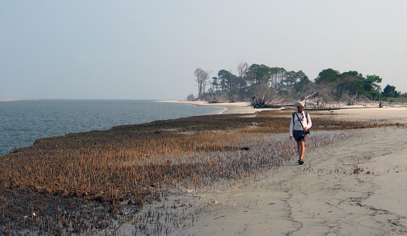
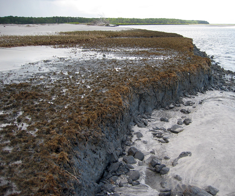
Overall view of relict marsh exposed on Cabretta Beach, Sapelo Island, Georgia. Me for scale, but photo taken 7 years ago, so the scale might now be slightly wider now. (Photograph taken by Ruth Schowalter.)

Just a little more than a week ago, my colleague Steve Henderson and I took a group of students from Emory University to Sapelo Island for a weekend field trip (detailed last week). One of our goals on this trip was to take them to a relict marsh on Cabretta Beach so that they could better appreciate how a sedimentary deposit makes a transition from living ecosystem to inert rock, yet filled with evidence of its formerly teeming life. Similar relict marshes are on St. Catherines Island and other Georgia-coast islands, but when it comes to teaching about taphonomy in the field, I prefer using the one on Sapelo.

Closer view of relict marsh on Sapelo Island, showing 500-year-old remains of smooth cordgrass (Spartina alterniflora), cross section of its muddy sediments, and quartz sand deposited on top by tides, waves, and wind. (Photograph by Anthony Martin.)

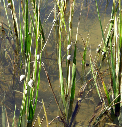
As mentioned in a previous entry, modern salt marsh on the Georgia coast have a few key components that make them among the most productive of all ecosystems: smooth cordgrass (Spartina alterniflora), marsh periwinkles (Littoraria irrorata), mud fiddler crabs (Uca pugnax), and ribbed mussels (Geukensia demissa). So if a Georgia salt marsh were to be buried quickly – say, by a storm that dumps a thick layer of sand on it – what would be preserved? The Cabretta relict marsh partially answers that question, showing us incipient trace and body fossils of these biota. They are not quite fossils, but on their way there, giving us a glimpse of the fossilization process well before it is completed.

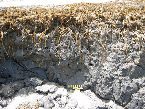
For example, the tall, green or golden stalks of smooth cordgrass that we see today, adorned my millions of marsh periwinkles (Littoraria irrorata), are absent from the relict marsh. Only the lowermost ochre-colored stubs and extensive root systems remain, and traces made by the roots below what was the marsh surface.

Modern smooth cordgrass (Spartina alterniflora) and its constant companions, marsh periwinkles (Littoraria irrorata) on Sapelo Island, Georgia.

Cross-sectional view of relict marsh, what is left from a formerly magnificent marsh: stubs, roots, root traces, and not many periwinkles. (Both photographs by Anthony Martin.)

Once in a while, I also find old marsh periwinkle shells scattered on the surface of the relict marsh. These are made of calcium carbonate and will dissolve in slightly acidic waters, so these might not last for long once exposed. The real reason for why these tend to disappear quickly, though, is modern hermit crabs. Hermit crabs encounter these periwinkle shells on the relict marsh surface, say “Hey, free shells!”, then happily trot away with these, not caring that their “new” homes are actually 500 years old.

No mud-fiddler crab remains were apparent on the surface, nor have I seen them in 20-30 visits to this relict marsh. This is not surprising, as their exoskeletons are made of chitin and dissolve more quickly than molluscan shells. Nonetheless, their burrows are always abundantly evident on the surface as perfectly round holes, which are sometimes accompanied by new burrows made by modern fiddler crabs, as well as bivalves that will bore into this firmground.

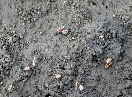
Modern salt marsh surface on Sapelo Island with mud fiddler crabs (Uca pugnax) showing off a few of the behavioral traits they do best: eating, fighting, mating, and burrowing. Note that burrows, surface scrapings, and pellets are a few of the traces they make. Which of these traces get preserved?

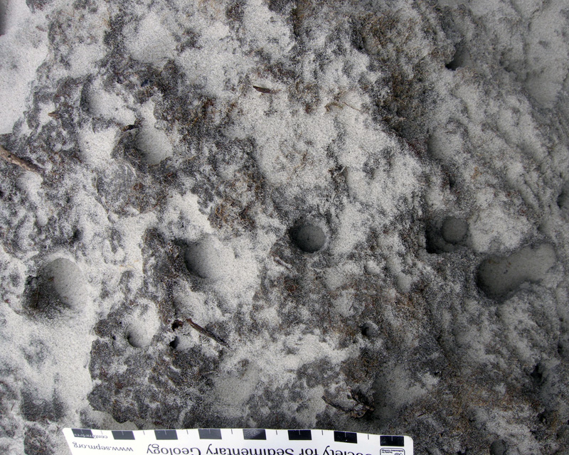
Close-up of eroded relict marsh surface, showing cross-sections of old fiddler-crab burrows now being filled with modern beach sand. Think of how this will look in the fossil record. (Scale in centimeters).

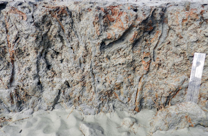
Longitudinal view of former fiddler-crab burrows associated with smooth-cordgrass root traces. Fill the deeper parts of these burrows with sand, and they’re more likely to get preserved as trace fossils. Scale to right is 15 cm (6 in) long. (All photographs by Anthony Martin.)

Modern ribbed mussels are harder for us to see in the field because we would have to wade into soft, deep, sulfurous mud to get close to them, and however amusing that might be, we don’t have time to do our laundry before getting back into our rental vans for the ride home. So the students take our word for it that those mussels are indeed in the marsh, then we point to the old ones clumped on the relict-marsh surface that are still in life position.

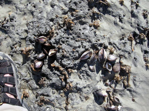
Cluster of ribbed mussels (Guekensia demissa) directly associated with stubs of smooth cordgrass on relict marsh surface. Now that they’re exposed, how long will these shells last on the surface? (Photograph by Anthony Martin.)

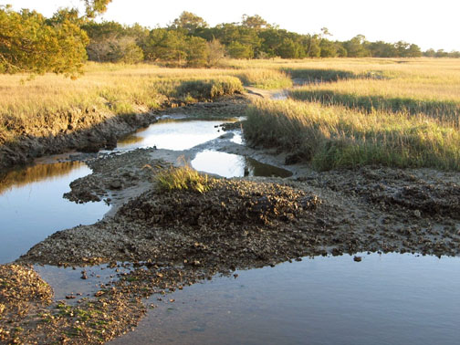
Oysters (Crassostrea virginica) are less common in the relict marsh, but given the right exposure, these can be observed on some visits too. These clumps of oyster shells mark the edges of tidal creeks that wound through the marsh.

(Top) Modern salt marsh with tidal creek cutting through it and oyster bank exposed at low tide, Sapelo Island.

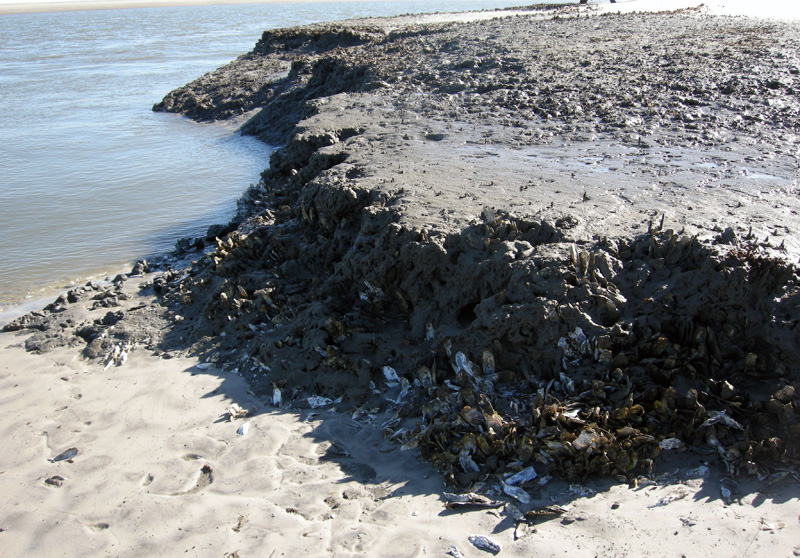
Former oyster bank peeking out of relict marsh, formerly buried for about 500 years, now revealed by erosion of the modern shoreline. (Both photographs by Anthony Martin.)

Because it was all too easy to spot the similarities between this relict marsh and a modern one less than 100 meters (330 feet) from where we stood, I then asked about other differences. For instance, take the fact that we were standing on the relict marsh while discussing its traits: could we do the same in the modern marsh nearby? No, was the universal answer, and I affirmed that they would likely be up to their waists in ribbed-mussel-produced mud. (I asked for volunteers to test this hypothesis, and they very smartly declined.)

This led to a discussion of why the relict marsh could be so firm, which introduced them to the concept of diagenesis: how a sedimentary deposit can change over time, an important consideration in taphonomy. Such alterations are especially apparent in muds, which lose considerable volume as these lose their water content, causing a “softground” to become a “firmground,” then eventually a “hardground.” The students were surprised when I told them that the relict marsh acting as the floor of our “classroom” was likely 2-3 times as thick as what was there now.

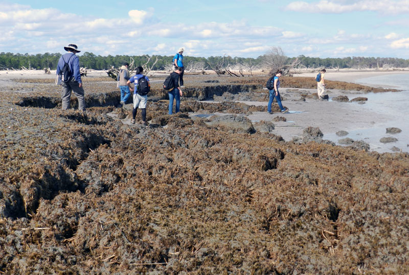
Would these students so blithely walk around on a modern salt marsh? I don’t think so, and please don’t experiment with this yourself. Nevertheless, a relict marsh, thanks to dehydration of its muds and compaction, is just fine for exploring on foot. (Photograph by Anthony Martin.)

We spent only about an hour at the relict marsh before regretfully walking back to our field vehicle, followed by a ferry ride to the mainland part of Georgia and a long drive home to Atlanta. Yet I felt assured that the lessons about taphonomy, ancient environments, ichnology, and diagenesis imparted by this relict marsh encompassed enough material to fill 4-5 class sessions in an indoor classroom. Moreover, if we had been all enclosed by four walls and a ceiling, and without a former marsh underfoot, there was no guarantee that these concepts would be understood or retained.

This is why we geoscientist-educators take our students outside, enriching our collective awareness of how environments change through time and how we piece together the clues left behind from ancient environments. It’s memorable, it’s fun, and it works. But don’t take my word for it. Whether you’re an educator or student, try it yourself sometime, whether on the Georgia coast or elsewhere, and see what happens.

Further Reading

Basan, P.B., and Frey, R.W. 1977. Actual-palaeontology and neoichnology of salt marshes near Sapelo Island, Georgia. In Crimes, T.P., and Harper, J.C. (editors), Trace Fossils 2. Liverpool, Seel House Press: 41-70.

Edwards, J.M. and Frey, R.W. 1977. Substrate characteristics within a Holocene salt marsh, Sapelo Island, Georgia. Senckenbergiana Maritima, 9: 215-259.

Frey, R.W. and P.B. Basan. 1981. Taphonomy of relict Holocene salt marsh deposits, Cabretta Island, Georgia. Senckenbergiana Maritima, 13: 111-155.

Frey, R.W., Basan, P.B. and Scott, R.M. 1973. Techniques for sampling salt marsh benthos and burrows. American Midland Naturalist, 89: 228-234.

Letzsch, W.S. and Frey, R.W. 1980. Deposition and erosion in a Holocene salt marsh, Sapelo Island, Georgia. Journal of Sedimentary Research, 50: 529-542.

Morris, R. W. and H. B. Rollins. 1977. Observations on intertidal organism associations on St. Catherines Island, Georgia. I. General description and paleoecological implications. Bulletin of the American Museum of Natural History, 159: 87-128.

Smith, J.M., and Frey, R.W. 1985. Biodeposition by the ribbed mussel Geukensia demissa in a salt marsh, Sapelo Island, Georgia. Journal of Sedimentary Research, 55: 817-825.

Ghost Crabs and Their Ghostly Traces

The ghost crabs of the Georgia barrier islands – all belonging to the species Ocypode quadrata – are among my favorite tracemakers anywhere, any time. My ichnological admiration for them stems from the great variety of behaviors they record in the beach and dune sands of the islands, telling many fascinating tales of what they were doing while no one was watching. Thus I thought it only appropriate that a blog entry posted close to Halloween deserved a story about an animal that not only has the word “ghost” in its common name, but one that also leaves mystifying marks of its unseen behavior.

On the dawn of June 22, 2004 on Sapelo Island (Georgia), my wife Ruth and I were presented with one of the most intriguing of ghost-crab mysteries related to their vestiges. We were scanning the freshly scoured surfaces of Nannygoat Beach on the south end of the island; high tide only a few hours before had cleansed the beach of the previous day’s traces. The low-angle rays of early-morning sunlight were optimal for contrasting any newly made animal signs on the beach, which is why we were there then. We went to the beach with our minds open to anything novel; indeed, my experience with the Georgia barrier islands is that no matter how many times you visit them, they always hold previously unsolved puzzles.

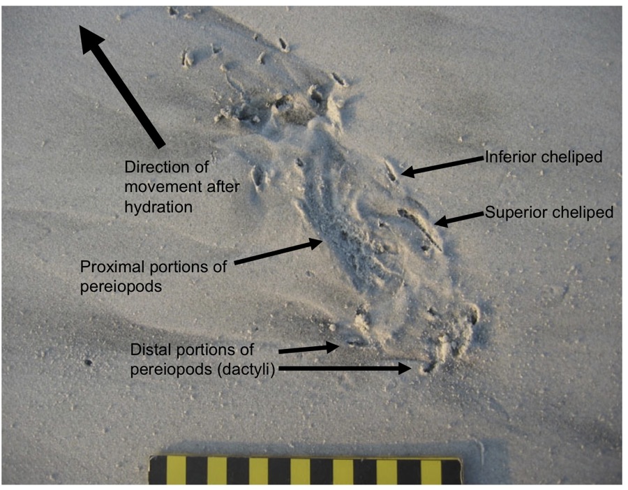
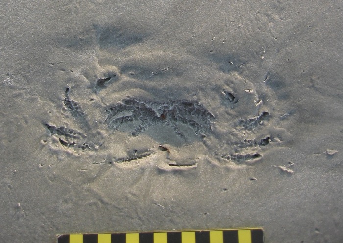
Sure enough, within about 15 minutes of stepping foot on the beach, Ruth paused and asked one of the most simple – yet important – of scientific questions: “What is this?” She pointed to a depression on the sandy surface, and what I saw was astonishing. It was a trace perfectly outlining the lower (ventral) half of a ghost crab, preserving in detail: impressions of all eight walking legs (pereiopods), including their pointed ends (dactyli); its smaller claw (inferior cheliped) and larger claw (superior cheliped); and its main, rectangular body.

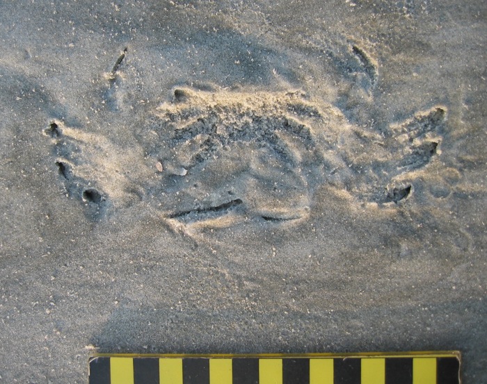
A perfect outline of the bottom side of a ghost crab (Ocypode quadrata), found just after dawn and high tide on Nannygoat Beach, Sapelo Island, Georgia. Why would a ghost crab make such a trace? (Scale in centimeters, and photograph taken by Anthony Martin.)

Even more strangely, only one set of tracks connected with this body imprint, leading away from it, and none moved toward it. This was not an impression made by the dead body of a crab. Instead, the tracks showed that the crab was very much alive when it made its resting trace and immediately afterwards. But what happened just before then? It looked as if the crab floated through the air, dropped vertically, made a perfect 10-point landing, sat there for a while, and walked away.

Another exquisitely defined ghost-crab body impression, and with tracks leading away from it, showing this is not a crab “death mask,” but one made by a live crab. (Scale in centimeters, and photograph taken by Anthony Martin.)

The same ghost-crab impression as above, but this time with the crab anatomy labeled and direction of movement after it stopped and sat down on the sand. What happened to the tracks that must have led to its resting spot? And what’s with that word “hydration”? Let’s just say this is what you call “foreshadowing” in the story. (Scale in centimeters, and photograph taken by Anthony Martin.)

Knowing that ghost crabs can do a lot of things, but not aerial acrobatics, we wondered how this could have happened. Well, single observations can be the start of good science, but for this inquiry to progress any further, we had to see if this seemingly unusual observation could be repeated. So we walked further south along the beach to test whether this was an isolated incident, or if we could find any other ghost-crab outlines with single trackways attached. With such a search image in mind, we quickly found about a dozen more such marks made by crabs of various sizes, but showing an identical behavior. Even better, all were located just below the high-tide mark of the previous night.

Yet another beautiful ghost-crab resting trace, surrounded by a scoured beach surface. Lot of these traces and all just below the high-tide mark meant something was happening that could be answered by the awesome power of science. (Scale in centimeters, and photograph taken by Anthony Martin.)

Time to think. These crabs must have walked to their resting places, but why didn’t they leave any tracks? We soon realized that the tracks were certainly made, but not preserved. So like all other surface traces on the beach, they must have been made erased during high tide. Yes, that was it! The crabs walked to the surf zone just after the high tide, sat down, waited long enough for the tide to drop a little bit, and walked away.

Mystery solved? Well, not quite. This was an incomplete explanation, one with a big, unanswered question. Why did the ghost crab walk to – and sit down in – the surf? (With a prompt like that, feel free to create your own intertidal-crab equivalent of “chicken-crossing-road” punch lines.) Ghost crabs normally spend much of their time in deep, J- or Y-shaped burrows close to or in the dunes, and above the high-tide mark. They are most active at night, when they come out of their burrows to scavenge delectable dead things dumped on the beach by waves and tides, or to prey on smaller invertebrates, like dwarf surf clams (Mulinia lateralis). They also leave their burrows to seek mates, which might involve one crab enticing another to check out its burrow.

A seemingly indignant and defiant ghost crab outside of its burrow during the day, either looking for new territory, food, mates, or all three. They’re greedy that way. In this instance, though, it was mostly running away from me and my camera. (Photograph taken by Anthony Martin.)

None of the crabs that made these traces were scavenging, preying, or mating, yet something in the surf was life-sustaining enough for them to risk becoming meals for early-morning predatory shorebirds. I searched my memory for what I had read previously about ghost crabs and their biological needs, and finally realized what could have driven them to the surf in the middle of the night: they were thirsty.

You see, ghost crabs are living examples of so-called transitional animalsthat evolution-deniers insist do not exist, having an interesting mixture of adaptations to different environments. These crabs are descended from fully marine crabs, so they still have gills that allow them to filter oxygen from marine water. Yet they also have little lungs and can breathe air, enabling them to stay out of the water for hours. Having both gills and lungs makes them semi-terrestrial, living in a world between the land and ocean, and dependent on both realms. They live close to the sea for their food, reproduction (females lay their fertilized eggs in sea water), and water, but their main livelihood is gained from the beach and dunes.

In this respect, ghost-crab burrows in the upper parts of beaches and lower parts of dunes provide protection against predators, but also keep the crabs hydrated. One of the functions of a ghost-crab burrow – which can be more than one meter (3.3 feet) deep, is to intersect the water table below. That way, when a crab needs water for proper respiration, it crawls down the burrow to that saturated area and replenishes it bodily fluids. But they can’t stay down there as the tide rises, so they move higher up the burrow to where there’s some air. Unlike blue crabs (Callinectes sapidus), which have completely developed gills and hence fully marine, if you keep a ghost crab in sea water too long, it drowns.

The previous night was a higher tide than normal, which probably flooded many of the ghost-crab burrows and causing these crabs to abandon their homes. This meant the crabs spent most of the night outside of their burrows, resulting in dehydration, but having to wait out the high tide. As soon as the tide turned and began to drop, the crabs ran to the surf zone, settled down into the wet sand, and soaked up water through small openings where the legs connect to the main body. Spiky “hairs” (setae) on their legs help with this water up-take, drawing up moisture from the sand through capillary action.

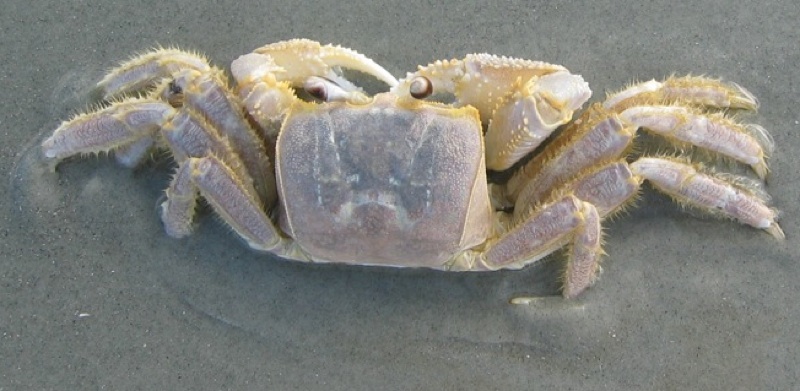
My legs? Sorry, I meant to shave. Guess you’ll have to deal with it. Hey, wait a minute: does that pose look like it could make anything you’ve already seen, like, oh, I don’t know, a resting trace? Keep reading. (Photograph by Anthony Martin.)

Ghost crabs are amazingly efficient at pulling water out of sand. So their hunkering down onto a saturated sandy surface with waves breaking on top of them must have been like the ghost-crab equivalent of drinking from a funnel, quenching their thirst in a most satisfying way. Meanwhile, waves washed away their tracks leading to these resting spots. They stayed a while, long enough for the tide to drop and expose the sandy beach surface. Only then did they get up and walk away, fully rehydrated, refreshed, and ready to go back to their burrows or dig new ones.

This was a detailed explanation, but one based entirely on traces and what little I knew about ghost crabs from the scientific literature. How else to test it and see whether it was right or not?

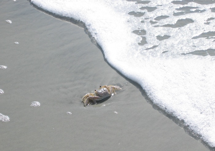
If you just said, “By directly observing this interpreted behavior in a ghost crab,” you would be right. A little more than a month later, on July 30, 2004, I actually got to witness this behavior, and on Nannygoat Beach. Back without Ruth this time, and by myself, I was looking for more traces following a high tide, when I saw a small, wraith-like movement out of the corner of my eye. It was a beautiful adult ghost crab, flat-out running in full daylight and heading straight from the dunes to the surf zone. I stood back and watched it reach the surf, where it promptly sat down and became still.

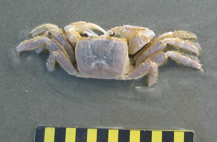
Here’s a ghost crab that doesn’t mind getting a soggy bottom. This one sprinted from the dunes to the surf, stopped abruptly, and sat a spell. (Photograph by Anthony Martin.)

I took photos while walking toward this crab, expecting it to bolt at any moment. Instead, I was instead surprised to see it remain where it sat, even as its eye stalks rotated to look warily at me. Amazed, I grasped that this one must have been thirsty enough to risk being eaten or stomped. The photo you see shows just how close I got to it, and I was thrilled to see it in exactly the same position depicted by the traces Ruth and I had seen the month before.

Although scientists aren’t always right, if you practice good science, you sometimes hit the nail on the head. Or the crab on the sand. Or, well, never mind. Anyway, this ghost crab is making a trace just like the ones documented the month before and in the same place, and it is a direct result of the same behavior interpreted from just the traces and some knowledge of their physiology. It’s almost as if science has predictive power. Who’d have thought? (Photograph by Anthony Martin.)

With the “resting trace = rehydration” hypothesis now supported by both traces and direct observation, I wrote the results into a formal, peer-reviewed paper. Unexpectedly, such traces had never been documented for ghost crabs, and especially from the perspective of a paleontologist. In the paper, published in 2006, I pointed out that this behavior would explain similar-looking trace fossils in the geologic record, or the preservation of crab bodies frozen in the same position by death, perhaps reaching the surf too late and being buried by wave-borne sands. The geological significance of such trace fossils would be their value in pointing exactly to where the surf may have washed across an ancient shore, millions of years ago. Geologists really like this kind of precision, and become grateful to ichnologists who give them such tools they can easily use in the field.

A fossil crab from the Miocene Epoch (about 15 million years old), preserved in a sandstone bed cropping out on a beach near Comodora Rivadavia, Argentina. This crab and others like it in the sandstone were all preserved the same way: nearly entire, implying they were buried quickly, and parallel to the original sandy surface on which they settled. Could these have died after dehydration near the surf, and then been buried? How long ago did some crabs evolve to become semi-terrestrial? I don’t know, but now we have a hypothesis that can be applied to fossils like these and tested. (Coin is about 2.5 cm (1 in) wide; Photograph by Anthony Martin.)

Since then, I have seen these resting traces on the beaches of every Georgia barrier island, in the Bahamas, and other places where ghost crabs dwell. Although trace fossils echoing this behavior in ghost crabs or their ancestors have not yet been found, I predict that with the right images now in mind, geologists and paleontologists will recognize them some day.

So with this ichnological lesson from ghost-crab traces, I hope they have become just a bit less “ghostly” and much more alive in your imaginations.

Further Reading

Duncan, G.A. 1986. Burrows of Ocypode quadrata (Fabricus) as related to slopes of substrate surfaces. Journal of Paleontology, 60: 384-389.

Martin, A.J. 2006. Resting traces of Ocypode quadrata associated with hydration and respiration: Sapelo Island, Georgia, USA. Ichnos, 13: 57-67.

Wolcott, T. G. 1978. Ecological role of ghost crabs, Ocypode quadrata (Fabricius) on an ocean beach: Scavengers or predators? Journal of Experimental Marine Biology and Ecology, 31: 67-82.

Wolcott, T. G. 1984. Uptake of interstitial water from soil: mechanisms and ecological significance in the ghost crab Ocypode quadrata and two gecarcinid land crabs. Physiological Zoology, 57: 161-184.

Georgia Life Traces as Art and Science

This past Friday evening (October 14), Fernbank Museum of Natural History in Atlanta, Georgia hosted the official opening of Selections, a visual-art show themed on evolution, especially as it relates to Charles Darwin. Many other art shows or other creative ventures have revolved around evolutionary themes, especially in 2009, which marked the 150th anniversary of On the Origin of Species and the 200th of Darwin’s birth. But two aspects of this display make it distinctive: (1) it was planned more than two years in advance to accompany the traveling exhibit Darwin, on loan at Fernbank from the American Museum of Natural History; and (2) five of the eight participating artists, all local to the Atlanta area, are also scientists.

Other than once again disproving the notion that artists and scientists live in divergent intellectual realms, once lamented by C.P. Snow in 1969 (for a few other examples of how this false dichotomy is becoming less and less defensible, look here, here, here, here, and here), I am pleased to share that my wife Ruth Schowalter and I are two of the artists in this show. Seven drawings and paintings of ours are on display, with three of those collaborative works, in which we freely mixed scientific concepts with our respective artistic expressions.

Here I will focus on just one of those works, a collaborative piece titled Abstractions of a Rising Sea (2011). My reason for taking a closer look at this one exclusively is because of its having been visually inspired by plant and animal traces of the Georgia barrier islands. Also, in keeping with a Darwinian theme, it depicts how changing environments – in this case, rising sea level – can likewise impact the survival of species, thus affecting the types of traces that are formed and preserved in a given place.

Abstractions of a Rising Sea (2011), by Ruth Schowalter and Anthony Martin: watercolor on paper, 66 X 101 cm (26” X 40”), on display at Fernbank Museum of Natural History until January 1, 2012. But this isn’t just abstract art: it’s also a scientific hypothesis. How so? Please read on. (Photograph taken by Anthony Martin.)

Although this painting may look abstract to most viewers, given its strange, funky shapes and patterns expressed with a colorful palette, its basic elements actually embody an evidence-based prediction. The artwork design, shown below, originated as a conceptual drawing I made for my upcoming book, Life Traces of the Georgia Coast; in fact, it will be the last illustration in the book. The drawing, which I later scanned and modified slightly with Adobe Photoshop™, portrays a vertical sequence of traces made by plants and animals on a typical Georgia shoreline, but considerably altered as sea level went up along that shoreline. In short, it reflects my prognosis of how a coastal dune will become inundated by the sea over the next few decades, with traces of marine animals succeeding those of terrestrial plants and animals.

The original illustration that inspired the artwork, which I drew to portray the sequence of traces that would be made in a given place on the Georgia coast as sea level goes up in the next few hundred years. (Illustration by Anthony Martin.)

So if you’ll bear with me for a few minutes, here’s a more detailed explanation. The traces at the bottom of the illustration represent those of a coastal dune, with plant-root traces, insect burrows, and sea-turtle nests. Just above, those traces are replaced by the burrows of ghost crabs, which are semi-terrestrial animals, but dependent on the sea. A typical Y-shaped burrow of a ghost crab (Ocypode quadrata), viewed in longitudinal section in the eroded face of a coastal dune on Sapelo Island, Georgia. This formerly open burrow was filled from above by sand of a slightly different composition, making it easier to spot. But also note that it cuts across the layering (bedding) of the dune, showing that the crab burrow is relatively younger than the dune deposit. (Photograph by Anthony Martin.)

Next are burrows made by marine invertebrates that live in the intertidal and shallow subtidal areas of a beach, such as polychaete worms, sea cucumbers, and acorn worms.

A variety of abandoned polychaete worm burrows, all washed out of their original places by a vigorous waves and tides and found along a beach on Sapelo Island, Georgia. Although each burrow is distinctive, what they share are behavioral adaptations to living in sandy environments dominated by the surf, shown by their reinforced walls. All four species of worms also orient their burrows vertically, which helps prevent too-frequent exhumation. (Photograph by Anthony Martin.)

Accompanying these is a snail shell (lower third, center) with a drillhole, a cannibalism trace made when a moon snail preyed on its own kind.

Drillhole in the shell of a common moon snail (Neverita duplicata) caused by another moon snail, a trace of both predation and cannibalism: Sapelo Island, Georgia (Photograph by Anthony Martin.)

A broken clam shell to the right of the snail is a likewise a predation trace, but attributable to a seagull. (The bird flew up with the clam in its beak, dropped it onto a hard-packed beach sand at low tide, and dined on its freshly killed contents.)

Broken shell of the giant Atlantic cockle (Dinocardium robustum), caused by a sea gull that picked it up, flew with it, and dropped it onto a sandflat at low tide on Sapelo Island, Georgia. Scale in centimeters. (Photograph by Anthony Martin.)

The upper half of the figure is then dominated by traces of marine invertebrates that live fully submerged offshore, such as ghost shrimp and other crustaceans, other polychaete worms, sea urchins, and brittle stars.

Labeled version of the illustration, depicting an overall progression from onshore traces (bottom) to offshore traces (above). If this sequence of sand and mud were to fossilize, this is how paleontologists and geologists would interpret it. (Illustration by Anthony Martin.)

The preceding artistic-scientific deconstruction should also help a viewer to better understand how geologists think when they look at a vertical sequence of sedimentary rock. For example, geologists follow several basic principles when trying to figure out the relative timing of different events in the geologic past.

One of these is called superposition, in which the effects of the oldest (first occurring) event in a given sequence of sedimentary rock are at the bottom, and the effects of subsequent events are recorded in progressively younger rocks toward the top.

The second principle is cross-cutting relationships, in that whatever is cutting across a previously existing structure must be younger than it. Think about how an animal burrow may cut across burrows made by previous generations of animals, and how you could unravel the sequence of “burrowing events” by simply observing which intersects which burrow.

A third principle is Walther’s Law, named after German geologist Johannes Walther (1960-1937) which states (more-or-less) that laterally adjacent environments succeed one another vertically. In other words, where a maritime forest and coastal dune are next to one another today on the Georgia coast, a drop in sea level means that coastal dunes might by succeeded vertically by the forest. Conversely, sea level going up implies that sediments of offshore environments, which are currently next to the beach and dunes, will some day overlie those of the dune.

Hence the illustration shows all three principles at play with a rising sea. For example, ghost-crab burrows cut across a sea-turtle nest from above, vertical burrows of a polychaete worm in turn dissect ghost-crab burrows below them, and a ghost-shrimp burrow from above interrupts one limb of a U-shaped acorn-worm burrow. Even better, a trained ichnologist can look at this sequence of traces and discern the environmental change that happened over the time represented by the sediments.

You can test this supposition by showing the illustration to other ichnologists, and I predict they will say, “Looks like sea level went up.” As a result, seemingly abstract patterns can become meaningful as we apply these images within the context of time passing, a concept we think Darwin – as a geologist and biologist – would have appreciated.

When I first showed this illustration to Ruth, she was quite taken by its forms and compositions, and she imagined what it would look like made much larger and in color. So we got to work on it, purposefully choosing a large piece of watercolor paper, onto which I drew the ichnological design. She then composed the color scheme, using a combination of water-color pencils and brushes, and I painted in a few details here and there, but most of the hard work was hers.

Ruth and my artistic styles are quite different – she’s a visionary artist, whereas I’m a more of a surrealist – but we both agree that meaningful art should provoke thought. So we very much like how this artwork also addresses and combines two contentious issues in American society: evolutionary theory and global-climate change. In Georgia, as in many other places in the U.S., scientists and science-educators still encounter resistance to the teaching of evolution, despite its extensive testing during the past 150 years and its consequent acceptance by virtually all scientists worldwide. Likewise, in recent years, so-called “global-warming deniers” have put much effort into rebuffing, ignoring, or otherwise downplaying the effects of human-caused climate change – despite near-universal scientific consensus – resulting in the twisting of scientists’ words or outright censorship.

For the plants, animals, and people who live on the Georgia coast, politically charged arguments become pointless as the shoreline moves up and over the land. As global climate continues to change and sea level goes up along the Georgia coast, how will life respond to these changes, especially if the sea rises faster than most organisms can adapt? This is a question we could have put to Charles Darwin, and one we attempt to pose through this synthesis of art and science.

(Acknowledgements to my wife and art-science collaborator, Ruth Schowalter, for her invaluable input on this post: thank you! Selections, featuring the artwork discussed here as well as others by us and six other artists, will be showing at Fernbank Museum of Natural History in Atlanta, Georgia until January 1, 2012. Admission to the museum includes viewing of the artwork, permanent exhibits, and the Darwin exhibit.)

Further Reading

Pilkey, O.H., and Fraser, M.E., 2005. A Celebration of the World’s Barrier Islands. Columbia University Press, New York: 400 p.

Purcell, W.S., and Gould, S.J., 2000. Crossing Over: Where Art and Science Meet. Three Rivers Press, New York: 159 p.

Trusler, P., Vickers-Rich, P., and Rich, T.H., 2010. The Artist and the Scientists: Bringing Prehistory to Life. Cambridge University Press, Cambridge, U.K.: 320 p.

The Lost Barrier Islands of Georgia

The Georgia coast is well known for its historic role in the development of modern ecology, starting in the 1950s and ongoing today. But what about geologists? Fortunately, they were not long behind the ecologists, starting their research projects on Sapelo Island and other Georgia barrier islands in the early 1960s. Indeed, through that seminal work and investigations afterwards, these islands are now renown for the insights they bestowed on our understanding of sedimentary geology.

Why would geologists be attracted to these islands made of shifting sand and mud that were nearly devoid of anything resembling a rock? Well, before sedimentary rocks can be made, sediments are needed, and those sediments must get deposited before solidifying into rock. So these geologists were interested in learning how the modern sands and muds of the barrier islands were deposited, eroded, or otherwise moved in coastal environments, a dynamism that can be watched and studied every day along any Georgia shoreline. The products of this sediment movement were sedimentary structures, which were either from physical processes – such as wind, waves, or tides – or biological processes, such as burrowing. Hence sedimentary structures can be classified as either physical or biogenic, respectively.

Cabretta Beach on Sapelo Island at low tide, its sandflat adorned with beautiful ripples and many traces of animal life. Sand is abundant here because of a nearby tidal channel and strong ebb-tide currents that tend to deposit more sand than in other places around the island. This sand, in turn, provides lots of places for animals that live on or in the sand, making trails and burrows, demonstrating how ecology and geology intersect through ichnology, the study of traces.  Speaking of traces, what are all of those dark “pipes” sticking out of that sandy surface? Hmmm… (Photograph by Anthony Martin.)

These geologists in the 1960s were among the first people in North America to apply what they observed in modern environments to ancient sedimentary deposits, and just like the ecologists, they did this right here in Georgia. For example, in 1964, a few of these geologists – John H. Hoyt, Robert J. Weimer, and V.J. (“Jim”) Henry – used a combination of: geology, which involved looking at physical sedimentary structures and the sediments themselves; modern traces made by coastal Georgia animals; and trace fossils. Through this integrated approach, they successfully showed that the long, linear sand ridges in southeastern Georgia were actually former dunes and beaches of ancient barrier islands.

These sand ridges, barely discernible rises on a mostly flat coastal plain, are southwest-northeast trending and more-or-less parallel to the present-day shoreline. Remarkably, these ridges denote the positions of sea-level highs during the last few million years on the Georgia coastal plain. The geologists applied colorful Native American and colonial names to each of these island systems – Wicomico, Penholoway, Talbot, Pamlico, Princess Anne, and Silver Bluff – with the most inland system reflecting the highest sea level. So how did these geologists figure out that a bunch of sand hills were actually lost barrier islands? And what does this all of this have to do with traces and trace fossils?

Map showing positions of sand ridges that represent ancient barrier islands, with each ridge marking the fomer position of the seashore. The one farthest west (Wicomico) represents the highest sea level reached in the past few million years, whereas the current barrier islands reflect an overlapping of two positions of sea level, one from about 40,000 years ago (Silver Bluff), and the other happening now. (Photograph by Anthony Martin, taken of a display at the Sapelo Island Visitor Center.)

Here’s how they did it. They first observed modern traces on Georgia shorelines that were burrows made by ghost shrimp, also known by biologists as callianassid shrimp. On a sandy beach surface, the tops of these burrows look like small shield volcanoes, and a burrow occupied by a ghost shrimp will complete that allusion by “erupting” water and fecal pellets through a narrow aperture.

Top of a typical callianassid shrimp burrow, looking much like a little volcano and adorned by fecal pellets, which coincidentally resemble “chocolate sprinkles,” but will likely disappoint if you do a taste test. (Photograph by Anthony Martin, taken on St. Catherines Island.)

A couple of ghost shrimp, which are either a male-female pair of Carolina ghost shrimp (Callichirus major) or a Carolina ghost shrimp and a Georgia ghost shrimp (Biffarius biformis). Sorry I can’t be more accurate, but I’m an ichnologist, not a biologist (although I could easily play either role on TV). Regardless, notice they have big claws, which they use as their main “digging tools.” The tracemakers look a little displeased about being outside of their protective burrow environments, but be assured I thanked them for their contribution to science, and promptly threw them back in the water so they could burrow again. Scale = 1 cm (0.4 in) (Photograph by Anthony Martin, taken on St. Catherines Island, Georgia.)

Just below the beach surface, these interior shafts widen considerably, making these burrows look more like wine bottles than volcanoes. This widening accommodates the ghost shrimp, which moves up and down the shaft to irrigate its burrow by pumping out its unwanted feces (understandable, that) and circulating oxygenated water into the burrow. Balls of muddy sand reinforce the burrow walls like bricks in a house, stuck together by shrimp spit, and the burrow interior is lined with a smooth wall of packed mud.

A small portion of a ghost-shrimp burrow, showing its wall reinforced by rounded pellets of sand and stuck together with that field-tested and all-natural adhesive, shrimp  spit. Photograph by Anthony Martin, taken on Sapelo Island.

Amazingly, these shafts descend vertically far below the beach, as much as 2-3 meters (6.5-10 feet) deep. Here they turn horizontal, oblique, and vertical, and tunnels intersect, branch, and otherwise look like a complex tangle of piping, perhaps reminding baby-boomers of “jungle gyms” that they used to enjoy as children in a pre-litigation world. Who knows what goes on down there in such adjoining ghost-shrimp burrow complexes, away from prying human eyes?

The deeper part of a modern ghost-shrimp burrow, exposed by erosion along a shoreline and revealing the more complex horizontally oriented and branching networks. Gee, do you think these burrows might have good fossilization potential? (Photograph by Anthony Martin, taken on Sapelo Island.)

See all of those burrow entrances on this sandy beach? Now imagine them all connecting in complex networks below your feet the next time you’re walking along a beach. Feels a little different knowing that, doesn’t it? (Photograph by Anthony Martin, taken on Sapelo Island.)

Interestingly, these burrows are definitely restricted to the shallow intertidal and subtidal environments of the Georgia coast, and their openings are visible at low tide on nearly every Georgia beach. Hence if you found similar burrows in the geologic record, you could reasonably infer where you were with respect to the ancient shoreline.

I think you now know where this is going, and how the geologists figured out what geologic processes were responsible for the sand ridges on the Georgia coastal plain. Before doing field work in those area, the geologists may have already suspected that these sandhills were associated with former shorelines. So with such a hypothesis in mind, they must have been thrilled to find fossil burrows preserved in the ancient sand deposits that matched modern ghost-shrimp burrows they had seen on the Georgia coast. They also found these fossil burrows in Pleistocene-age deposits on Sapelo Island, which helped them to know where the shoreline was located about 40,000 years ago with respect to the present-day one. This is when geologists started realizing that the Georgia barrier islands were made of both Pleistocene and modern sediments as amalgams of two shorelines, and hence unlike any other known barrier islands in the world.

Vertical shaft of a modern ghost-shrimp burrow eroding out of a shoreline on Cabretta Beach, Sapelo Island. Scale in centimeters. (Photograph by Anthony Martin.)

Vertical shaft of a fossil ghost-shrimp burrow eroding out of an outcrop in what is now maritime forest on Sapelo Island, but we know used to be a shoreline because of the presence of this trace fossil. Scale in centimeters. (Photograph by Anthony Martin.)

Geology and ecology combined further later in the 1960s, when paleontologists who also were well trained in biology began looking at how organisms, such as ghost shrimp, ghost crabs, marine worms, and many other animals changed coastal sediments through their behavior. So were these scientists considered geologists, biologists, or ecologists? They were actually greater than the sum of their parts: they were ichnologists. And what they found through their studies of modern traces on the Georgia barrier islands made them even more scientifically famous, and these places became recognized worldwide as among the best for comparing modern traces with trace fossils.

Further Reading:

Hoyt, J.H., and Hails, J.R. 1967. Pleistocene shoreline sediments in coastal Georgia: deposition and modification. Science, 155: 1541-1543.

Hoyt, J.H., Weimer, R.J., and Henry, V.J., Jr. 1964. Late Pleistocene and recent sedimentation on the central Georgia coast, U.S.A. In van Straaten, L.M.J.U. (editor), Deltaic and Shallow Marine Deposits, Developments in Sedimentology I. Elsevier, Amsterdam: 170-176.

Weimer, R.J., and Hoyt, J.H. 1964. Burrows of Callianassa major Say, geologic indicators of littoral and shallow neritic environments. Journal of Paleontology, 38: 761-767.