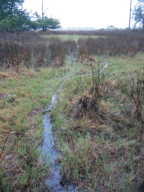
Deconstructing an Ichnology Abstract, with Alligators

Many people from outside of the realm of academia (or is it a fiefdom?) prefer to get the latest scoops on new paleontological or geological research directly from the source, rather than just reading a press release or news article about it. As someone looking from the inside out, I’m pleased to see so many non-scientists try to probe one layer deeper with their understanding of a beloved scientific topic that interests them, and I try to encourage it through my own blogging, speaking, teaching, and other forms of outreach.
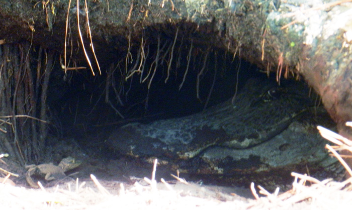
An alligator den on St. Catherines Island, (Georgia), with baby alligator and “big momma” alligator for scale. This week, I presented a poster with about these big burrows and their makers  at the Society of Vertebrate Paleontology meeting in Raleigh, North Carolina. The original field work we did for this research was reported back in March here, and now we’re ready to share more of what we found out. (Photograph by Anthony Martin.)

Unfortunately, many of the original research articles that become subjects of media attention are behind paywalls, requiring a reader to pay for access to read those articles, even if the research was publicly funded. This practice is especially common if the research is published in one of those glamorous journals that seemingly make or break academic careers in science, regardless of the lasting quality of the research. (I won’t name them directly, but let’s just say that’s the nature of science nowadays.)

So one option for these curious folks is to read abstracts from proceedings volumes of professional meetings. Abstracts, which ideally are succinct summaries highlighting the most significant findings of a given study, can thus serve as a way for the public to at least get a few insights on the latest scientific research happening in their favorite disciplines.
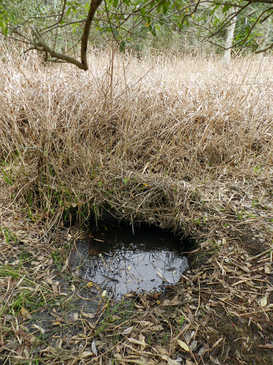
Want to get below the surface with this research? Oh, sorry, I was just being metaphorical. You really don’t want to go below the surface of an alligator den, which is why we mostly studied abandoned ones, mapped them, and otherwise tried to use methods that didn’t bother the alligators or otherwise have uncomfortable encounters with them.

Along those lines, the annual meeting of the Society of Vertebrate Paleontology (SVP) has been taking place this week in Raleigh, North Carolina, and it has an abstract volume associated with the meeting. Regrettably, though, the general public does not have access to these abstracts, only SVP members and people who have registered for the meeting. The Society of Vertebrate Paleontology also has a policy regarding researchers who publicly share their research results based on these abstracts, muddied by the word “embargo.” In short, this policy holds that people working for the media, which include reporters and bloggers (the latter of whom are also sometimes reporters), cannot write about and otherwise publicize research results presented at the meeting. That is, unless the researchers have given their permission to do so, or the results have been freely distributed by the researchers through a press release, blog, or other forms of outreach.

So in the spirit of the public having easier access to this primary scientific information, the following is our SVP abstract, which I presented as a poster at the meeting yesterday. The abstract is co-authored with Michael Page (Emory University), Sheldon Skaggs (Georgia Southern University), and R. Kelly Vance (also Georgia Southern University), and we worked together on the research, writing, and editing of the abstract. Because this abstract also includes a lot of scientific shorthand (charitably referred to as “jargon”), I also included a sentence-by-sentence explanation of it, in which the abstract text is in italics and my explanation is in formal typeface. So I hope you, the gentle reader, get something from this exercise in explanation, and we look forward to sharing more of this research with you as it continues to evolve and we publish it sometime next year as a peer-reviewed paper.

DENS OF THE AMERICAN ALLIGATOR (ALLIGATOR MISSISSIPPIENSIS) AS TRACES AND THEIR PREDICTIVE VALUE FOR FINDING LARGE ARCHOSAUR BURROWS IN THE GEOLOGIC RECORD

MARTIN, Anthony J., Emory University, Atlanta, GA, United States; PAGE, Michael, Emory University, Atlanta, GA, United States; SKAGGS, Sheldon, Georgia Southern University, Statesboro, GA, United States; VANCE, Robert K., Georgia Southern University, Statesboro, GA, United States

Large archosaur burrows are rarely interpreted from the geologic record, a circumstance that may be attributable to a lack of search images based on modern examples, rather than actual rarity.

Archosaurs make up an evolutionarily related group of vertebrates that include crocodilians (alligators and crocodiles), dinosaurs (the non-bird ones, that is), birds, and their extinct relatives. A few of the larger extinct archosaurs may have dug burrows, but paleontologists have reported very few of these, with one exception being the small Cretaceous ornithopod dinosaur Oryctodromeus cubicularis, found in its burrow with two juveniles of the same species. The authors are proposing here that this “rarity” of archosaur burrows in the fossil record might be more attributable to paleontologists not knowing what modern archosaur burrows look like. So they don’t recognize the fossil ones, leading to a perceived rarity rather than an actual one.

To test this idea, we measured, imaged, and mapped den structures of the American alligator (Alligator mississippiensis) on St. Catherines Island (Georgia, USA).

By “measured,” I mean that my colleagues and I used a low-tech instrument known as a “tape measure” to assess the width and height of an alligator den entrance. By “imaged,” we used a much more technologically complex instruments and method, called ground-penetrating radar (GPR) in combination with computers to figure out what these dens looked like below the surface. By “mapped,” I mean that we looked for alligator dens on St. Catherines Island (Georgia) and recorded their locations using a handheld GPS (global positioning system) unit, then plotted the distribution of these points to see if any patterns emerged.

St. Catherines is an undeveloped barrier island on the Georgia coast, consisting of Pleistocene and Holocene sediments.

St. Catherines Island is undeveloped in the sense that very few buildings or people live on the island year-round. It is privately owned and reserved for researchers’ uses under the direction of the St. Catherines Island Foundation. Like most of the Georgia barrier islands on the southern part of its coast, St. Catherines also has a geologically complex history. Its northwestern end is made of sediments deposited about 40,000 years ago – during the Pleistocene Epoch – whereas its southeastern end is made of much more recent sediments from the Holocene Epoch.

Alligators dug most dens along the edges of freshwater ponds in loosely consolidated Holocene or Pleistocene sand.

This sentence doesn’t need much more explanation other than to reemphasize that alligators gravitate to freshwater ecosystems to dig their dens (pictured below), not saltwater ecosystems, like salt marshes or coastal dunes.

Adult female alligators use dens to protect offspring, but burrows also aid in thermoregulation or serve as refugia for alligators during droughts and fires.

This is probably the neatest insight we gained from doing the research, is that the dens aren’t just used by big momma ‘gators for raising baby ‘gators, but also to make sure alligators of all ages are cozy during winters, stay wet during droughts, and are safe from fires. For instance, because southern Georgia has been going through a drought the past few years, some of the occupied dens we saw were in places that were high-and-dry, but the dens themselves intersected the local water table (seen in one photo above).

Some dens are evidently reused and modified by different alligators after initial construction.

This is an important point for paleontologists to know, and probably shouldn’t have been buried so far into the abstract, but we couldn’t very well put it at the beginning, either. Dens, like other homes, get used again, and probably by generations of alligators. This means that once a den is dug, stays open, and has a wetland nearby, alligators may just move into an abandoned den and modify it if needed, an alligator form of “home improvement.”

Drought conditions along the Georgia coast have exposed many abandoned dens, thus better allowing for their study while increasing researcher safety.

The drought is bad for alligators but was good for us when we did our field work, because so many dens were abandoned and exposed on dry land. This also eased any concerns we had about bothering the alligators, but especially alleviated worries we might have had about close encounters with protective parents near occupied dens. To be sure, we ran into a few of those, but not as many as we would have if conditions had been wetter.
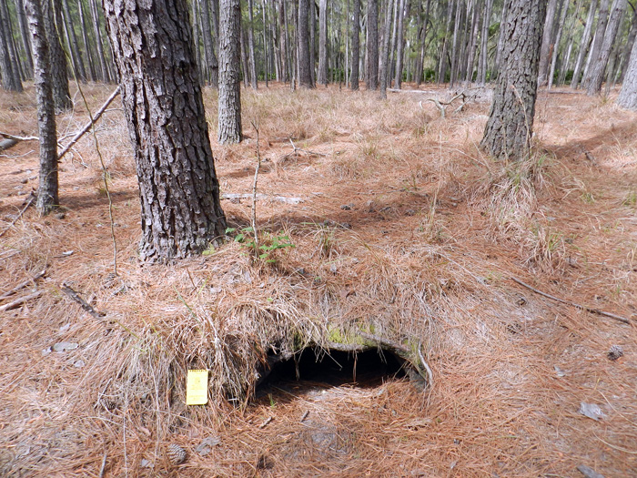
Den entrances have half-moon cross-sections, and based on one sample (n = 20), these range from 22-115 cm wide (mean = 63 + 23 cm) and 14-55 cm high (23 + 9 cm).

I like throwing numbers into ichnology, just to remind people that this is a part of it as a science. Although our sample size is small compared to other studies of traces and trace fossils, it gives people an idea of the range of sizes of these dens, or at least their entrances. As an exercise in the imagination, think about whether you could squeeze into one of these. You know, if you were crazy enough to do such a thing.

In addition to field descriptions, we applied geographic information systems (GIS) and ground-penetrating radar (GPR) to help define the ecological context and subsurface geometry of these structures, respectively.

Computer-aided mapping methods like GIS helped us to test how alligators decided to make dens as a function of the landscape. For instance, we found most of their dens were in lower-elevation areas, which made sense when you think about water accumulating in those places. And the GPR served the dual purpose of not bothering the alligators if they were in their dens, while also keeping us away from their, um, denizens. (Sorry.)

GIS gave spatial data relatable to alligator territoriality, substrate conditions, and proximity to potential nest sites. GPR produced subsurface images of active dens, which were compared to abandoned dens for a sense of taphonomic history.

Big alligators tend to stay away from other big alligators. They also tend to burrow in sediments that don’t take too much effort for them. Female alligators also make their nests close to water bodies and dens, so their little tykes don’t have to travel so far to the water. Newer, active dens were also compared to those no longer being used to see what happens to them over time with neglect, kind of like how an old, abandoned house tends to fall apart and collapse on itself over time.

Most den entrances are southerly facing, with tunnels dipping to the northwest or northeast.

This is pretty self-explanatory, but I’ll just ask readers to think about why these dens are oriented like this.

From entrances, tunnels slope at about 10-15°, turn right or left within a meter, and lead to enlarged turn-around chambers.

Pure description here too, but by “turn-around chamber,” that means the den has enough room inside the den for a big adult alligator to go in head-first and turn around so that it’s head is right at the entrance. (See the photo of “big momma” at the top for an example of that.)

Collapsed dens in formerly ponded areas (secondary-succession maritime forests) provided further insights into subsurface forms of these structures.

Dens left high-and-dry from years ago and taken over by forests collapsed in a way that we could see the full outline of the den and measure these.

These features are: 3.1-4.6 m long; 30-40 cm deep, relatively narrow at either end (35-60 cm), and 1.2-1.6 m wide in their middles.

Dude. Those are big burrows. Dude.

Expansive areas were probable turn-around chambers, and total volumes of collapsed dens accordingly reflect maximum body sizes of their former occupants.

The bigger the den, the easier it was for a large occupant to turn around in it. And although smaller, younger alligators could have lived in these dens, some of the dens were too small to allow the really big alligators from moving into them.

One sampled area (8,100 m2), an almost dry former pond, had 30 abandoned dens, showing how multiple generations of alligators and fluctuating water levels can result in dense concentrations of alligator burrows over time.

Think of an area about the size of an American football field, and put 30 alligator dens in that area. (Now that would make for an interesting game, wouldn’t it?) These dens weren’t all made at the same time, though, and were constructed or abandoned as the pond filled or dried out, respectively.

In summary, the sheer abundance, distinctive traits, and sizes of these structures on St. Catherines and elsewhere in the Georgia barrier islands give paleontologists excellent search images for seeking similar trace fossils made by large semi-aquatic archosaurs.

That’s the big take-home message here for vertebrate paleontologists. All of the information we gathered about these alligator dens from the Georgia barrier islands, especially what they look like, can be applied to test the fossil record of archosaurs. In other words, did archosaurs actually leave lots of dens for us to find, but we just didn’t know what to look for? Hopefully we’ll find out because of this research.
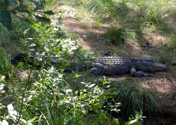
Later, denning ‘gator. (Photograph by Anthony Martin, taken on St. Catherines Island, Georgia.)

(Special thanks to Ruth Schowalter for assisting with the field work, and to the St. Catherines Island Foundation for funding some of the research.)

Source of Abstract (Reference):

Martin, A.J., Page, M., Vance, R.K., and Skaggs, S. 2012. Dens of the American alligator (Alligator mississippiensis) as traces and their predictive value for finding large archosaur burrows in the geologic record. Journal of Vertebrate Paleontology, 32 [Suppl. to No. 3]: 136.



Out of One’s Depth in the Ediacaran

In my previous post, which followed a field trip to see a spectacular assemblage of 565-million-year-old Ediacaran body and trace fossils at Mistaken Point in Newfoundland, I made an awkward confession. This admission was that the stock phrase “the present is the key to the past,” used by geologists and paleontologists to describe actualism (also known as uniformitarianism) really depends on which past you’re talking about. As it turns out, when it comes to earth history, there are a lot of pasts.

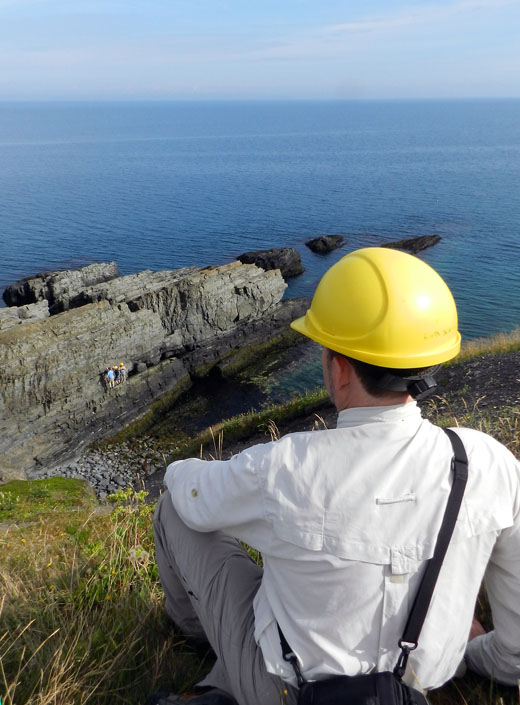
Looking from afar onto the world standard for rocks recording the transition from life that lived superficially to life that, well, went a little deeper. (Photograph by Ruth Schowalter, taken at Fortune Head, Newfoundland (Canada).)

For instance, if you mean to apply that aphorism while referring to the last 12% of earth history, then for the most part you’ll be OK, although some of it will fall completely flat (more on that later).

But if you think it can be said blithely when referring to a time when all of the lifeforms looked like aliens from a bad Star Trek episode (TOS, of course), or when global oxygen levels were significantly lower than today, or the ozone layer protecting us from UV radiation was mostly absent, or deep-burrowing predators were completely unknown from every ecosystem, or the geochemistry of bottom sediments in the world oceans were radically different, then that’s not going to work so well for you. The world was vastly different at the Precambrian-Cambrian transition about 550 million years ago, and no amount of studying modern geological and biological processes or, say, modern traces of the Georgia barrier islands, is going to close that factual gap.

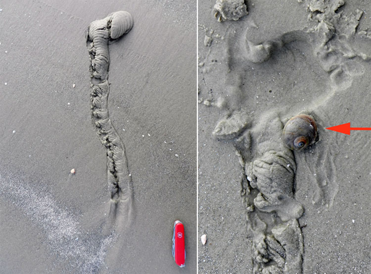
Underneath the intertidal sandflats of the Georgia barrier islands lurks the common moon snail (Neverita duplicata), detected through its burrow (left); and it radiates malevolence once exhumed from the burrow end (right, arrow). It is the top predator, the lion of the tidal flat, one might say, burrowing under sandflat surfaces to stalk its prey (other mollusks, including its own species), enveloping them with its muscular foot, and drilling into their shells to eat them alive. Simple, effective, and deadly. Was there anything like this moon snail in the Ediacaran Period, 635-542 million years ago? Nope. (Photographs by Anthony Martin, taken on Jekyll Island, Georgia.)

So let’s say you took a common moon snail from the Georgia coast and sent it back to the Ediacaran. You would think its evolutionarily advanced status, placed among such primitives, means that it would suddenly become the gastropod equivalent of a Terminator (the Summer Glau version, of course), wiping out every Ediacaran challenger in its mucus-lined path. Instead, it would die and quick and messy death from a combination of low oxygen levels, excessive biomats getting in its way, a lack of desirable prey, and excessive UV radiation. So you can stop building that gastropod-sized Tardis, and just face up to two realities: (1) the present is not always the key to the past; and (2) there is no such thing as time travel.

Oh yeah, back to the field trip. During the same excursion that included a stop at Mistaken Point, we also went to Fortune Head. Fortune Head is the place where the International Commission on Stratigraphy established the standard stratigraphic boundary for the switch from the Precambrian to the Cambrian. Called a Global Boundary Stratotype Section and Point (GSSP), or simply “stratotype,” this is a section of rock with the most nearly complete transition of rock units representing one time unit to the next.

A plaque at Fortune Head Ecological Reserve, informing visitors about the scientific importance of this site to geologists and paleontologists.

For example, the outcrop at Fortune Head is the stratotype for the transition from the Ediacaran Period (635-542 mya) to the Cambrian Period (542-488 mya). Sometimes geologists nickname this system of picking an exact boundary “the golden spike,” invoking images of a geologist hammering such a gaudy implement into the outcrop to imperiously announce its precise location. Lacking such geo-bling, though, we settled for one of the field trip leaders simply pointing with his walking stick to the boundary.

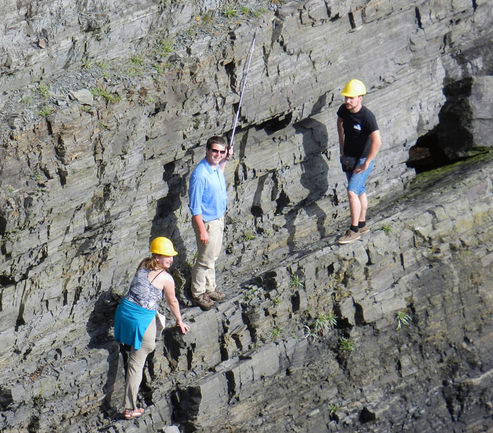
While we stayed safely on the hillside, the graduate students risked their lives to climb down onto the section and point at the Ediacaran-Cambrian boundary at Fortune Head, Newfoundland. For me, this brought back fond memories of Marlin Perkins, Jim Fowler, and Wild Kingdom. (Spoiler: the graduate students made it back OK.) (Photograph by Anthony Martin.)

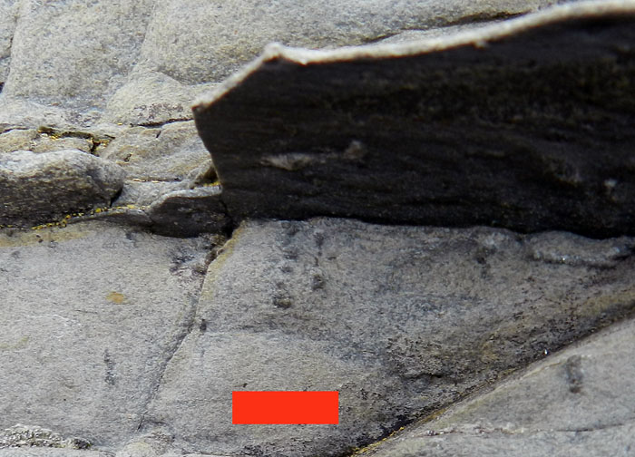
So how would you know for yourself where, er, when you are – geologically speaking – in a section that has the youngest rocks of the Ediacaran Period and the oldest rocks of the Cambrian Period? That’s where the awesome power of ichnology comes into play, and it’s really simple to wield. If you look at the rocks and see the following trace fossil – Treptichnus pedum – you’re in the Cambrian Period. But if you don’t, you’re in the Ediacaran.

Whoa, check out that beautiful trace fossil! It’s Treptichnus pedum, a burrow made by a deposit-feeding animal, which was probably a worm-like animal, but also could have been an arthropod. Regardless of who made it, it’s a burrow reflecting a new behavior that evidently didn’t exist only a few million years before it was made. And that, boys and girls, makes this trace fossil a distinctive one. Scale in centimeters. (Photograph by Anthony Martin, taken at Grand Bank, Newfoundland.)

This trace fossil, a feeding burrow made by an invertebrate animal living in the seafloor 542 mya, is one of the few trace fossils used as an index fossil. Index fossils (also called guide fossils) tell you the age of the rocks you’re viewing. A good index fossil should have the following traits:

  • Abundant
  • Easily identifiable
  • Stratigraphically restricted
  • Geographically widespread

Treptichnus pedum indicates a behavior very different from every other trace fossil seen in Ediacaran rocks. It shows that the burrowing animal – probably a type of worm or arthropod – systematically probed into the sediment to ingest some of it, withdrew back into the main part of its burrow, then moved forward to probe again. Furthermore, over the course of making its burrow, its pathway may make loops, which increased the likelihood of it getting lots of goodies (organics) from the sediment. This behavior was totally different, and if it had been allowed to happen in the Ediacaran, no doubt would have led to laughter and ostracizing by other epifaunal and infaunal invertebrates. That is, if they could laugh or ostracize. (Hey, like I said, it was really different back then.)

But here’s the really strange dimension of the Ediacaran Period: as far as burrowers were concerned, it was mostly two-dimensional. Animal movement seemed restricted to horizontal planes, in which animals (worm-like or otherwise) squirmed, crawled, anchored and pulled, or whatever they did to get around, but stayed mainly in the plane.

Vertical movement, such as daring to burrow up or down in the sediment, was forbidden by either the rules of the marine ecosystems at that time, or by the bodies of the animals themselves. What kept animals from digging a little deeper? Part of the problem was that the seafloor was ruled by microbial mats, which covered sediment surfaces like plastic coverings on furniture at your grandma’s home.

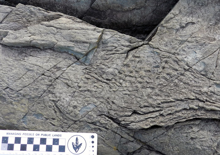
This wrinkled surface on a Lower Cambrian sandstone just above the Ediacaran-Cambrian boundary at Fortune Head, Newfoundland is evidence of a probable microbial mat, or “biomat” These biomats were really common in the Ediacaran, became less common in the Cambrian, then after the Cambrian became more rare than a modest politician in an election year. Scale in centimeters. (Photograph by Anthony Martin.)

So if you were an animal then, you had no choice: you could adapt to being under these mats or on top of them. To make matters worse, all animal life apparently lacked the right hard parts, limbs, or other anatomical traits that could have pierced those mats or excavated the sediment underneath them. So no amount of rugged individualism in those invertebrates was going to change their horizontal movement to vertical.

A horizontal trail, probably made by an invertebrate animal, preserved on a 565-million-year-old bedding plane at Mistaken Point, Newfoundland. So you thought you could burrow vertically? Forget it, Jake – it’s Ediacaratown!

Of course, eventually the earth changed, the tyranny of the microbial mats was overcome by new evolutionary innovations in animals, and other adaptive paths took life into a third dimension. Consequently, the animals living on the seafloor started acting more like the ones we see today: not just living on or just underneath that seafloor, but also going down into it. This change was huge in an ecological sense, sometimes dubbed by paleontologists as the agronomic revolution, which accompanied the Cambrian explosion. This is not to say that revolutions must involve explosions, though. On the contrary, this was a quiet and slow sort of revolt, in which as earth environments changed, natural selection favored the burrowers, and the burrowers changed their environment. ¡Viva la revolución!

Here’s a little musical lesson about the increased biodiversity of the Cambrian Period. Professors, assign it to your students. Students, tell you professors about it, so they can look like they’re almost hip when they assign it. And for American viewers: the song has some sort of subversive subliminal message toward the end, praising some country other than the U.S. You’ve been warned.

In this respect, what was most meaningful about our visit to Fortune Head was seeing evidence of this ecological shift at the very same outcrop holding the stratotype for the Ediacaran-Cambrian boundary. Small, thin burrows preserved in the rocks from the earliest part of the Cambrian Period, spoke of this difference in the way life related to the seafloor. Vertically oriented they were, having gone into the sediment at a depth only the width of my fingernail. Nonetheless, it was a start, and an important one, heralding the evolution of ecosystems that more closely approach those of today.

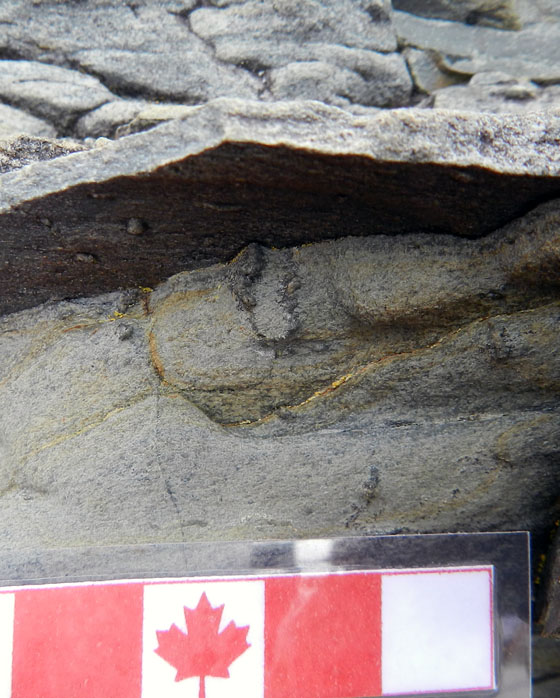
See that little U-shaped burrow just below that thin sandstone? It only goes about a centimeter down, but that’s deeper than nearly any other burrow you would see in rocks from the Ediacaran Period. This sort of simple U-shaped burrow is given the ichnogenus name Arenicolites by ichnologists. Canadian-themed scale is in centimeters. (Photograph by Anthony Martin, taken at Fortune Head, Newfoundland.)

Same goes for this burrow, which is a spiral – cut on its side – and named Gyrolithes. Scale bar = 1 cm (0.4 in). (Photograph by Anthony Martin, taken at Fortune Head, Newfoundland.)

Life has moved further downward since, from worms to arthropods in marine environments, then later from millipedes to dinosaurs to gopher tortoises in continental environments, looking to places well below the surface that they could call home. So it was a awe-inspiring privilege to see a sample from the geologic record of when this first started, one centimeter at a time.

What was next stage for burrowing animals in the world’s oceans during the next 100 million years or so? To answer that question, we’ll jump ahead to the Ordovician Period, shuttling between rocks and trace fossils of that age in both Newfoundland and Georgia (USA, y’all). But while doing this, we’ll also look for glimpses of how these Ordovician trace fossils get just a little bit closer to the traces we being made in the modern sediments of the Georgia coast, and thus more like the actualism we all know and love.

Further Reading

Bottjer,D.J., Hagadorn, J.W., and Dornbos, S.Q. 2000. The Cambrian substrate revolution. GSA Today, 10(9): 1-7.

Canfield, D.E., and Farquhar, J. 2009. Animal evolution, bioturbation, and the sulfate concentration of the oceans. Proceedings of the National Academy of Sciences, 106: 8123-8127.

Gingras, M., et al. 2011. Possible evolution of mobile animals in association with microbial mats. Nature Geoscience, 4: 372-375.

Seilacher, A. 1999.Biomat-related lifestyles in the Precambrian. Palaios, 14: 86-93.

Vickers-Rich, P., and Komarower, P. (editors). 2007 The Rise and Fall of the Ediacaran Biota. Geological Society of London, Special Publication 286: 448 p.

Mistaken Point and the Limits of Actualism

Sometimes we paleontologists, especially those who also study modern organisms and their behaviors, get a little too sure of ourselves, thinking we have a clear vision of life during the pre-human past. So it’s good to have that confidence shaken a little, made uneasy by a glimpse at a much deeper past, one that preceded the bulk of fossils that shape our accepted norms and basic expectations in paleontology.

Welcome to the Ediacaran Period, the span of earth history from 635-542 million years ago, and a time when actualism – the precept that the present is the key to the past – becomes a naïve, idealistic dream, a glib summary of a world that has only existed for a mere 12% of earth history.

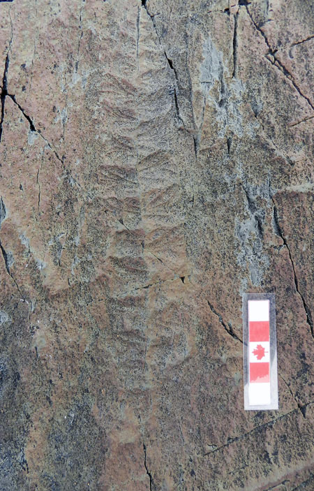
What are these? They’re fossils, but otherwise I’m not sure what else to tell you: guess I’ve been spending too much time in the present. But for for those people who have studied them and know better than me, they’re called Charniodiscus, and they’re frond-like fossils with holdfasts (those circular parts connected to their stems) that kept them attached to the seafloor about 565 million years ago. All you have to do to see these fossils is go to Newfoundland, Mistaken Point Ecological Reserve in Newfoundland, Canada, get permission from the Reserve to visit them, have a guide accompany you, and walk 40-45 minutes to the site from a car park. Incidentally, there will be absolutely no cafes or toilets on the way there. You know, just like how it was in the Precambrian. (Photograph by Anthony Martin; scale in centimeters.)

These discomforting realizations started a little less than two weeks ago, inspired by a field trip to the Ediacaran-Cambrian rocks of eastern Newfoundland, Canada. Why was I in cool, temperate Newfoundland, instead of sweating it out on the summertime Georgia coast? The occasion was a pre-meeting trip associated with the International Congress on Ichnology, simply known among ichnologists as Ichnia. This was the third such meeting, a once-every-four-years event (coinciding with years of the summer Olympics). The previous two were in Krakow, Poland (2008) and Trelew, Argentina (2004), and thus far these meetings also include fabulous field trips.

For Ichnia 2012, upon seeing an announcement of a field trip to Mistaken Point and other localities associated with the Precambrian-Cambrian boundary, I eagerly signed up for it. You see, Mistaken Point is world famous for its extraordinary preservation of more than 1,000 body fossils of those weird and wonderful fossils known as the Ediacaran fauna, Ediacaran biota, Vendian fauna, or Vendobionts (take your pick). This was the main reason why my fellow ichnologists on the field trip – 16 of us from 9 countries – were along for the ride, despite the trip’s clear emphasis on body fossils.

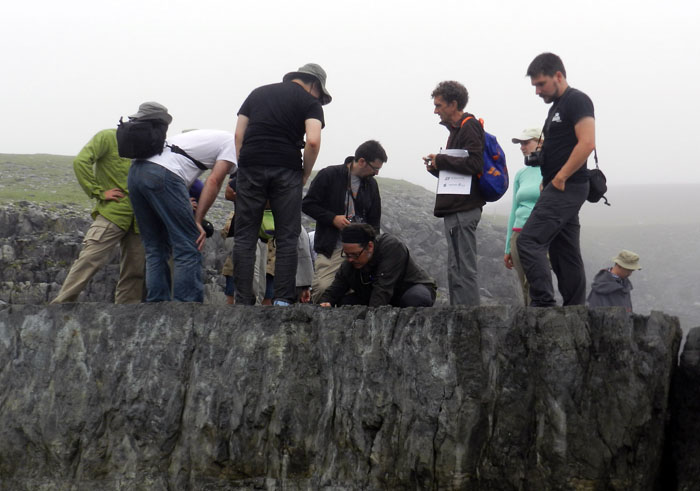
A rare photo of ichnologists getting really excited about seeing body fossils, which is totally understandable when we’re talking about the Ediacaran fossils at Mistaken Point, Newfoundland. Eventually, though, they later became unruly and started demanding, “Show me your trace fossils!” Fortunately for the sake of international ichnological relations, the field-trip leaders happily obliged that same day. (Photograph by Ruth Schowalter.)

These rare fossils, which are strange enough to even cause paleontologists to question whether or not they are animals (hence the cautious use of the more inclusive term “biota” instead of “fauna”), are abundantly exposed on broad bedding planes in Mistaken Point Ecological Reserve on the southeastern coast of Newfoundland. Discovered in 1967, these fossils have since proved to be one of the best examples of easily visible body fossils from more than 542 million years ago, and the Newfoundland fossils comprise the only such assemblage that originally lived in deep-marine environments. They evidently died in place when suffocated by a layer of volcanic ash that settled onto the seafloor, hence the fossils reflect a probable sample of their original ecosystem. This ash layer neatly preserved the fossils, and its minerals provided a means to calculate absolute age dates for the assemblage, which is from 565 +/- 3 mya (million years ago).

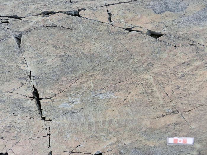
Bedding-plane exposure at Mistaken Point with many frond-like fossils, broadly referred to as rangeomorphs. (Photograph by Anthony Martin, Canadian-themed scale is in centimeters.)

A close-up of one of the more exquisitely preserved rangeomorphs, which I think is Fractofusus misrai. But you really shouldn’t trust this ichnologist with that identification, so it’d be wise to double-check that with a real expert. (Photograph by Anthony Martin.)

Just a few years ago, though, Mistaken Point became paleontologically famous again, and this time for its trace fossils. Researchers from Memorial University in Newfoundland and Oxford University looked at bedding planes near those holding the the body fossils, and were surprised to find a few trails there. At that time, it was the oldest evidence of animal movement from the fossil record, and although these finds have been disputed and others have tried to stake this claim for trace fossils elsewhere, it is still holding up fairly well.

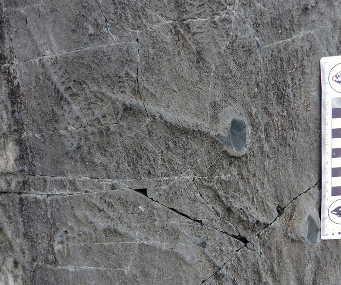
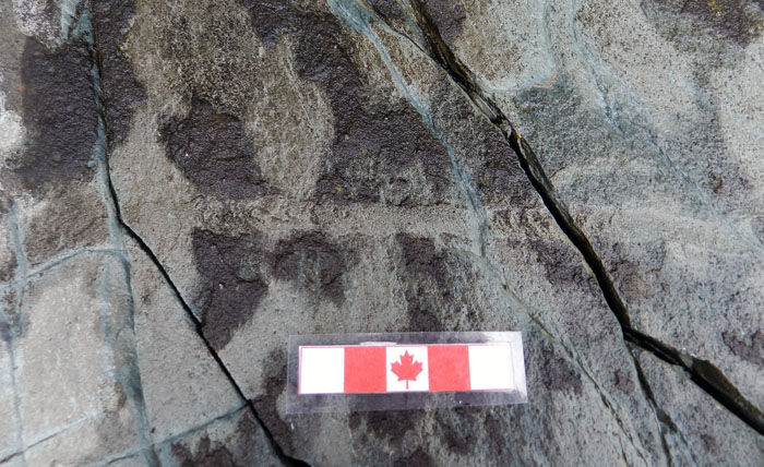
A surface trail, probably made by a < 1 cm wide animal moving along the seafloor about 565 mya. The animal moved from left to right, which is indicated by the crescentic ridges inside the trail, which open in the direction of movement. (Photograph by Anthony Martin, taken at Mistaken Point, Newfoundland.)

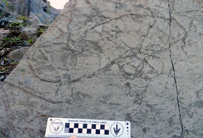
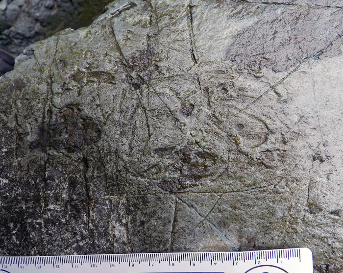
Another surface trail, but this one without the internal structure of the other one, and with levees on either side of the central furrow. (Photograph by Anthony Martin, taken at Mistaken Point, Newfoundland.)What’s this? Don’t have a clue. It looks like a series of overlapping trails, some looping, but would have taken me several hours to unravel. Anyway, it generated some good discussion at the outcrop, and they’re probably trace fossils, which made us ichnologists both happy and perplexed. (Photograph by Anthony Martin, taken at Mistaken Point, Newfoundland; scale in centimeters.)

What made these trace fossils? It’s hard to say, and that’s a humbling statement for me to make. In public talks I’ve given about my upcoming book, and in a presentation I gave the following week at Ichnia on the Memorial University campus, I’ve assured how the actualism of the Georgia barrier islands and its traces can reliably serve as models for interpreting many trace fossils formed in different environments, and trace fossils of various geologic ages from around the world. But in this instance, I didn’t have a inkling of what made the Mistaken Point trace fossils. These trace fossils were also made in deep-marine environments, which are lacking from the Georgia coast, and I haven’t learned much about deep-marine trace fossils from elsewhere.

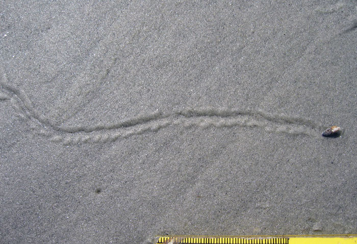
In short, my ignorance was showing, and these trace fossils were completely out of my realm of experience. The only feeble hypothesis I could conjure on the basis of what I’ve seen in modern sediments of the Georgia barrier islands are small marine gastropod trails. Sorry, that’s all I got.

Oooo, look, it’s snail! Making a trail! Isn’t that neat? And if you squint really hard and have a couple of beers, you might agree that it almost resembles one of the fossil trails from Mistaken Point. Don’t see it yet? Here, have another beer. (Photograph by Anthony Martin, taken at Sapelo Island, Georgia; scale in millimeters. )

But if ignorance loves company, I can feel good in knowing that others have grasped at the same straw of actualism and found it far too short. I could tell a few of my ichnological colleagues were likewise a little challenged by what they saw at Mistaken Point, and I knew that for some of them – like me – they normally deal with trace fossils in much younger rocks. But hey, that’s what geology field trips are supposed to do: challenge us with what’s really there in the rock record, right there in front of us, rather than what we wish were there.

Fortunately, a little more information provided during the meeting after the field trip helped my understanding of the trace fossils we saw at Mistaken Point, and actually connected to modern tracemakers. Alexander Liu, the primary author of the paper that first reported the trace fossils, gave a talk that reviewed the evidence for Precambrian trace fossils, including those from Mistaken Point. In experiments he and his coauthors did with living anemones in a laboratory setting, they were able to reproduce trails similar to the Mistaken Point trace fossil with the internal structure. Thus these researchers were able to use actualism to assist in their interpretation, which also meant that neoichnology was not so useless after all when applied to the Ediacaran. That made me feel a little better.

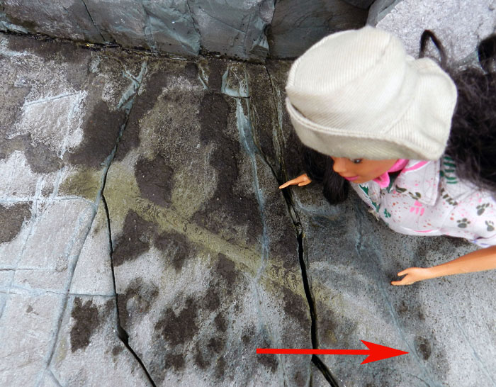
Let’s take a look at that first surface trail again, but this time with the help of my trustworthy colleague Paleontologist Barbie, who was along for the field trip. The crecentic ridges in the interior of the trail may represent marks where the basal disc of a anemone-like animal pushed against the surface as it moved. Even more interesting, the arrow points to an oval impression, which may be a resting trace that shows the approximate basal diameter of the tracemaker. What was the tracemaker? It’s currently identified as a small anemone, which is based on modern traces. Neoichnology rules! (Photograph by Anthony Martin.)

Ediacaran trace fossils still engender debate, though, and especially with people who don’t necessarily accept that animals made trails during the Ediacaran. For instance, about four years ago, some scuba-diving researchers observed a giant protozoan making a trail on a sediment surface in the Bahamas. Accordingly, they proposed that one-celled organisms – not animals – could have made similar trails during the Ediacaran Period. Interestingly, this shows how actualism can produce conflicting results when applied to Ediacaran fossils. After all, it’s still a big world out there, and we humans haven’t really observed everything in it yet.

So I’ll make one last point about Ediacaran fossils here, then will move on to more recent times. If you think that at the very least we paleontologists should be able to tell the difference between trace fossils and body fossils in Ediacaran rocks, you’re also in for some confusion. In the only research article I have ever attempted on Ediacaran fossils, which were much closer to Georgia – coming from the Carolina Slate Belt of North Carolina – my coauthors and I struggled with exactly that question with some fossils found in that area. In the end, we said they were body fossils, not trace fossils. And as everyone knows, I love trace fossils, and I really wanted these to be trace fossils. But they were not. That’s science for you: denying your deepest desires in the face of reality.

So surely the Cambrian would be easier to interpret, right? I meanl, after 542 mya, animals started burrowing merrily, to and fro, hither and tither, with uninhibited and orgiastic abandon, and, well, you get the idea. But, not really. Another part of the field trip involved looking at what happened with the departure of the relatively unbioturbated alien world of the Ediacaran, pre-542 mya, to the more familiar sediment mixing of the Cambrian and Ordovician Periods, post-542 mya. Yet even these rocks and their trace fossils were still not quite like what we see today.

This will be the subject of my next post, which will again explore the theme of how we should approach strict actualism like any scientifically based idea: with a mixture of astonished wonder, but also with a hard-edged look at what is really there.

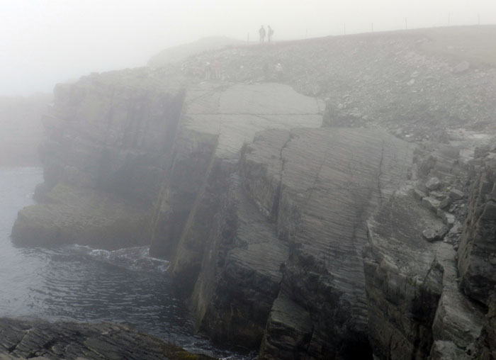
As we bid adieu to Mistaken Point and began our walk back to the car park, we could swear we saw lifeforms emerging from the mist-covered rocks, resurrected from the deep time and deep water of the Avalonian Precambrian. Then we realized those were just some of our group behind us. Oh well. Maybe next time. (Photograph by Anthony Martin.)

(Acknowledgements: Much appreciation is extended to the field trip leaders – Liam Herringshaw, Jack Matthews, and Duncan McIlroy – for their organization and execution of a fantastic three-day field trip; to Valerie and Richard of the Mistaken Point Ecological Reserve for guiding us to the site; to my ichnological colleagues for their cheery and knowledge-broadening company; and my wife Ruth for being with me and providing an artist’s perspective about her experiences with us crazy ichnologists, shared here and here.)

Further Reading

Fedonkin, M., Vickers-Rich, P. Grey, K., and Narbonne, G. 2007.The Rise of Animals: Evolution and Diversification of the Animalia. Johns Hopkins Press, Washington: 320 p.

Liu, A.G., McIlroy, D., and Brasier, M.D. 2010. First evidence for locomotion in the Ediacaran biota from the 565Ma Mistaken Point Formation, Newfoundland. Geology, 38: 123-126.

Matz, M.V., Frank. T.M., Marshall, N.J., Widder, E.A., and Johnsen, S. 2008. Giant deep-sea protest produces bilaterian-like traces. Current Biology, 18: 1-6

Tacker, R.C., Martin, A.J., Weaver, P.G., and Lawver, D.R. 2010. Trace vs. body fossil: Oldhamia recta revisited. Precambrian Research, 178: 43-50.

Vickers-Rich, P., and Komarower, P. (editors). 2007 The Rise and Fall of the Ediacaran Biota. Geological Society of London, Special Publication 286: 448 p.

Alien Invaders of the Georgia Coast

(This is the first in a series of posts about invasive species on the Georgia barrier islands, their traces, the ecological impacts of these traces, and why people should be aware of both their traces and impacts.)

Paleontologists like me face a challenge whenever we study modern environments while trying to learn how parts of these environments might translate into the geologic record. Sure, we always have to take into account taphonomy (fossil preservation), through which we acknowledge that nearly none of the living and dead bodies we see in a given environment will become fossilized; relatively few of their tracks, trails, burrows, or other traces are likely to become trace fossils, either.

Because of this pessimistic (but realistic) outlook, paleontologists often rub a big eraser onto whatever we draw from a modern ecosystem, telling ourselves what will not be there millions of years from now. We then retroactively apply this concept – a part of actualism or, more polysyllabically, uniformitarianism – to what happened thousands or millions of years ago. When paleontologists do this, they assume that today’s processes are a small window through which we can peer, giving insights into processes of the pre-human past.

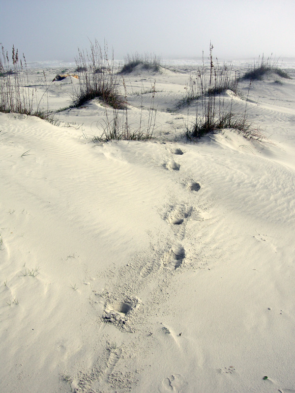
Feral horse (Equus caballus) tracks crossing coastal dunes on Cumberland Island, Georgia. During their evolutionary history, horses originated in North America and populations migrated to Asia, but populations in North America went extinct during the Pleistocene Epoch about 10,000 years ago. Using the perspective of geologic time, then, could someone argue that horses are actually “native,” and these feral populations are restoring a key part of a pre-human Pleistocene landscape? (Photograph by Anthony Martin.)

However, a huge complication in our quest for actualism is this reality: nearly every ecosystem we can visit on this planet is a hybrid of native and alien species, the latter introduced – intentionally or not – by us. Thus when we watch modern species behaving in the context of their environments, we always need to always ask ourselves how non-native species have cracked the window through which we squint, through the past darkly.

This theme is considered in Charles C. Mann’s most recent book, 1493: Uncovering the New World Columbus Created, in which he argues how nearly all terrestrial ecosystems occupied by people were permanently altered by the rapid introduction of exotic species worldwide following Columbus’s landfall in the Western Hemisphere. Going even further back, though, the introduction of wild dogs (dingoes) into mainland Australia by humans about 5,000 years ago irrevocably changed the environments of an entire continent. Examples like these show that European colonization and its aftermath in human history during the last 500 years was not the sole factor in the spread of non-native species, and hints at how species invasions have been an integral part of humanity and its movement throughout the world.

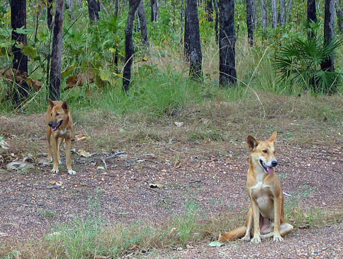
Something tells me we’re not in Georgia any more. A male-female pair of dingoes (Canis lupus dingo) pose for a picture in Kakadu National Park, Northern Territory, Australia. Although now considered “native,” dingoes are an example of an invasive species that had a huge impact once brought over by people from southeast Asia about 5,000 years ago. For one, its arrival is linked to the extinction of native carnivorous mammals in the mainland Australia, such as thylacines (Thylacinus cynocephalus) and Tasmanian devils (Sarcophilus harrisii). (Photograph by Anthony Martin.)

Well-meaning (but deluded) designations of “pristine,” “untouched,”and “unspoilt” aside, the Georgia barrier islands are no exception to alien invaders. Moreover, like many barrier-islands systems worldwide, they differ greatly from island to island in: which species of invaders are there; numbers of individuals of each species; and the degree of how these organisms impact island ecosystems and even their geological processes.

Feral cat tracks in back-dune meadows of Jekyll Island, Georgia. Jekyll is one of the few Georgia barrier islands with a significant human presence year-round, hence these cats are descended from domestic cats that were either purposefully or accidentally let loose by residents. What impact do these cats have on native species of animals and ecosystems, and are these effects comparable to those of other invasive species on other islands? Scale = 15 cm (6 in). (Photograph by Anthony Martin.)

This is one of the reasons why I devoted several pages of my upcoming book, Life Traces of the Georgia Coast, to the traces of invasive species – tracks, trails, burrows, and so on – despite their failing an “ecological purity test” for anyone who might prefer to focus on native species and their traces. With regard to invasive species, the genie is out of the bottle, so we might as well study what is there, rather than apply yet another metaphorical eraser to species that are drastically shaping modern ecosystems and affecting the behavior of native species, thus likewise altering their traces.

A large pit of disturbed sand in a back-dune meadow caused by feral hogs (Sus crofa) on St. Catherines Island, Georgia. Because feral hogs are wide-ranging omnivores with voracious appetites, they cause considerable alterations to island habitats, from maritime forests to intertidal beaches. How do these traces affect the behavior and ecology of other species, especially native ones, in such a broad range of environments on the Georgia barrier islands? Can their traces actually alter the geological character of the islands? (Photograph by Anthony Martin.)

What are some of these invasive species? What makes for an “invasive species” versus a mere “exotic species”? How do the traces of invasive species affect native species on the Georgia barrier islands, and the ecology and geology of the islands themselves? And how do paleontologists and geologists figure into the study of invasive species?

These are all questions that I hope to explore in upcoming weeks here, and for the sake of simplicity, I will showcase an invasive species of mammal and its traces each week. Some of the photos shown here serve as a visual teaser of the invasive species and their traces that will be covered: feral horses (Equus caballus), cattle (Bos taurus), hogs (Sus crofa), and cats (Felis domestica). Yes, I know, there are many others, but these four are among the most ecologically significant species, they consist of animals that nearly everyone knows, and – best of all – they make easily identifiable traces. So these fours species will provide a starting point in our learning how the Georgia barrier islands can be used as case studies in the traces and ecological effects of traces made by invasive species.

Trail made by feral cattle (Bos taurus) cutting through a salt marsh and extending to the horizon, providing a clue of how this forest-dwelling animal can travel deeply into and affect marginal-marine environments. How might such traces show up in the geologic record, and was there a species that might have made similar traces on the islands in the recent past? (Photograph by Anthony Martin.)